Guayaquil
An old travel guide, in a moment of unkindness, once counted Guayaquil's attractions as one: "The Public Cemetery." That kind of thing stings. For decades Ecuador's largest city was something travelers endured on their way to the Galapagos, a hot, humid, and somewhat dangerous port that owed its existence to the river and not much else. Then, starting in the early 2000s, something changed. The Malecon 2000 project reclaimed the riverfront. The Las Penas neighborhood, the oldest district where the city was first founded, got repainted and opened to tourists. Iguana Park was suddenly full of iguanas - dozens of them, lounging across the grass and the benches and the trees. The Cemetery is still there. But nobody needs to count it as the city's only attraction anymore.
The Long River Walk
The Malecon Simon Bolivar, often called Malecon 2000, runs for roughly 2.5 kilometers along the west bank of the chocolaty brown Rio Guayas. Walk it from north to south and you pass through a sequence of attractions: La Planchada, a bastion point with cannons pointed at where the pirate ships used to come upriver; the MAAC museum with its archaeological and contemporary art collections; an IMAX theater; La Perla, the 57-meter Ferris wheel that opened in 2015 and rises from the promenade; the Jardines del Malecon with its manicured landscape beds; the Hemicycle de La Rotonda, a granite monument marking the 1822 meeting between Simon Bolivar and Jose de San Martin; and the Torre Morisca, a 1930s octagonal clock tower. At the southern end sits the Centro Comercial Malecon, a riverside shopping center. Along the way, joggers, vendors, families, and tourists move in both directions, forming the continuous stroll that defines the modern downtown.
Four Hundred Steps Up
Where the Malecon ends at its northern tip, Las Penas begins. This is where Guayaquil was founded - originally on a hill called Cerro Santa Ana, with the harbor at its base - and the neighborhood was rebuilt and painted in bright colors during the early 2000s regeneration project. To reach the top, visitors climb 444 numbered steps lined with ice cream vendors, snack sellers, and artisan shops. Each step is painted, and the facades of the houses lining the route are painted too, in vivid yellow and blue and pink and turquoise. At the top sits a lighthouse, a small museum called Museo El Fortin, and the Iglesia del Cerro Santa Ana chapel. The panoramic view from the top takes in the Rio Guayas, the downtown skyline, and the Duran side of the river across the water. The climb takes about twenty minutes if you stop for ice cream.
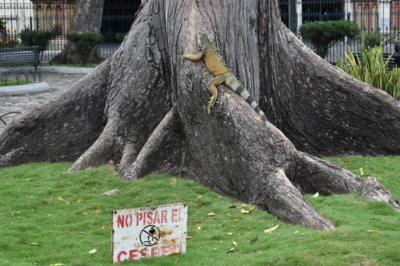
The Iguana Park
Seminario Park, a relatively small green square in the heart of downtown across from the cathedral, is home to hundreds of land iguanas. They are genuine wild iguanas that have colonized the park and decided to stay - eating the leaves, sunning themselves on benches, and tolerating tourists who take their photos. Nobody knows exactly why iguanas chose this particular park. City staff feed them lettuce. Iguanas being iguanas, they are mostly still, occasionally dramatic when one does move, and entirely indifferent to the constant stream of visitors. The park sits opposite the Guayaquil Cathedral, whose neo-Gothic bell towers loom over the scene. For a city that had to work hard to attract tourism, handing out lettuce to a population of urban iguanas turned out to be a minor publicity coup.
Where to Eat, What to Try
Guayaquileno food draws heavily on the river and the ocean. Try encebollado, the national hangover dish - albacore tuna soup with yuca, pickled red onions, and a splash of lime. Ceviche here usually means shrimp, since the Gulf of Guayaquil is one of the world's major shrimp-farming regions. Seco de pollo is chicken stewed with beer and cilantro. Caldo de salchicha is a blood-sausage soup that takes getting used to. Shawarma shows up everywhere in Guayaquil, thanks to a century-old Lebanese immigrant community that has become thoroughly Ecuadorian. The Urdesa neighborhood's main street, Victor Emilio Estrada, is the place to find it, along with good small food carts called carretillas. In Samborondon across the river, upscale dining spans Japanese, Italian, American, and Ecuadorian. For something uniquely local, El Patacon in Urdesa serves dishes built around verde - green plantains.
How to Move, and When
Metrovia is the city's bus rapid transit system, three lines that cost 25 cents a ride and serve downtown, the bus terminal, and the airport. The Rio Daule terminal is across the street from the main bus station. Match the bus code (T1, CS, T3) to the station you want, not every bus stops at every station. For areas Metrovia doesn't cover, taxis are the way - but only use official yellow cabs or Cabify or Uber, and agree on a price (or confirm the meter is running) before the cab moves. Local bus systems within the city are notoriously confusing and subject to theft, with phone snatching particularly common. Guayaquil is hot and humid year-round, with a wet season from January to April bringing heavy rainfall. The dry season from May to December offers cooler evening breezes. Either way, carry water, and if you plan to visit during the day, start early.
From the Air
Guayaquil sits at approximately 2.19 degrees south, 79.89 degrees west, on the west bank of the Guayas River near the Gulf of Guayaquil. Jose Joaquin de Olmedo International Airport (SEGU / GYE) serves the city, with a main runway elevation of roughly 20 feet. City population is approximately 2.7 million; metropolitan area population is about 3.6 million. From altitude, look for the wide Guayas River delta, the distinctive skyscraper cluster rising from the downtown area, the long Malecon strip along the western bank, and the industrial port complex south of the city center. The neighboring Duran lies across the river, connected by pedestrian bridges to Santay Island. Tropical savanna climate means heavy rains January through April; best aerial visibility is May through December. Watch for afternoon convective cloud buildup during the wet season.
Nearby Stories
- Guayas Province 20 km away
- Montañita 29 km away
- Santa Elena, Ecuador 39 km away
- 2023 Guayas earthquake 48 km away
- El Cajas National Park 50 km away
- Santiago de Bolivar 57 km away
- Alausí Canton 67 km away
- Department of Tumbes 158 km away