Iron Quadrangle
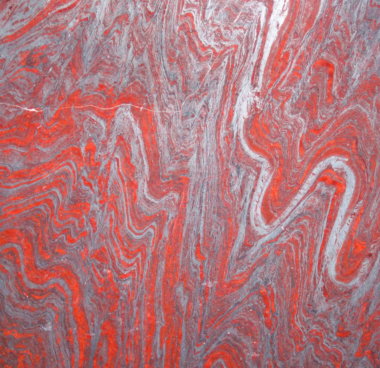
The rocks in the Iron Quadrangle are 2.5 billion years old. They were laid down on the edge of the São Francisco craton - the ancient geologic heart of southern Brazil - when the atmosphere first filled with enough oxygen to rust the dissolved iron in the oceans and drop it, band by band, onto the seafloor. That ancient sediment became itabirite: a high-grade iron ore striped with quartz and jasper, so pure that impurities were cooked out during later metamorphism. The wealth built from it has paid for cities, shifted Portuguese colonial policy, and - twice in five years - killed hundreds of people in tailings dam collapses.
Four Billion Years in Stripes
The Iron Quadrangle is a mineral-rich region of roughly 7,000 square kilometers in south-central Minas Gerais, named for its roughly four-sided shape. The ore deposits sit within the Cauê Formation, part of the Minas Supergroup, a sequence of meta-sedimentary rocks deposited between 2.6 and 2.12 billion years ago on the continental shelf of the São Francisco craton. Beneath it lies Archean basement rock - gneiss and migmatite from 3.2 to 2.61 billion years ago. Above it, the Sabará Group covers the whole sequence with turbidites, volcaniclastics, and diamictites. The iron ore itself is itabirite, a metamorphic variant of banded iron formation in which quartz and jasper have recrystallized into distinguishable grains, with hematite and magnetite in thin bands. This material produces exceptionally high-grade iron because sulfur and phosphate impurities were driven out during the metamorphic processes around 2.2 to 1.8 billion years ago - a collision known as the Transamazonian Orogeny, part of the assembly of the supercontinent Columbia. In October 2022, the International Union of Geological Sciences recognized these formations by naming them one of the first 100 Geological Heritage Sites in the world.
The Gold Rush That Moved an Empire
European settlers first learned of the region's mineral wealth in 1690. Diamonds followed not long after. The Portuguese crown imposed the *quinto* - a one-fifth tax on production - and the Brazilian Gold Rush began in earnest, running from the late 17th century through the late 19th. Between 1500 and 2000, the Iron Quadrangle produced about 40 percent of all the gold mined in Brazil. The demographic impact was staggering. Hundreds of thousands of Europeans migrated to the region from Portugal and northern Brazil. At least half a million enslaved Africans were brought to work the mines and *lavras* - a number that transformed the demographics and culture of Minas Gerais permanently. The wealth shifted Portuguese Brazil's center of gravity: power and population moved away from the sugar plantations of the northeast and toward this interior mining region. When gold production slowed in the late 18th century, the economy pivoted to iron ore extraction and agriculture - coffee and dairy - without losing its hold on the national economy.
Belo Horizonte and the Modern Quadrangle
Today more than four million people live in the Iron Quadrangle. Belo Horizonte - planned in the 1890s to be a modern replacement for the colonial state capital at Ouro Preto - is the regional economic hub, processing most of the gem and mineral wealth that still flows from the surrounding mines. Other significant settlements include Santa Luzia, Ibirité, and Itabira - the latter the birthplace of the poet Carlos Drummond de Andrade, and still a mining town. Steel production and metallurgy dominate the regional economy, with tourism and agriculture providing secondary income. The region's pegmatite dikes - intruded into the older rock formations - host the gemstones that gave Brazil its reputation as a source of tourmalines, aquamarines, and topaz.
Mariana, 2015
On 5 November 2015, the Fundão tailings dam at the Germano mining complex near Mariana collapsed. Tailings dams hold mining waste - slurry of water, sediment, and crushed rock left over after ore is extracted - behind earthen walls. When Fundão failed, approximately 60 million cubic meters of this slurry flowed downstream. Nineteen people died. Around 200 homes were destroyed. The wave of waste reached the Rio Doce and flowed all the way to the Atlantic, roughly 650 kilometers away, contaminating the river along its entire length. Water supplies for communities downstream were cut off for days and weeks. The dam was operated by Samarco, a joint venture between Vale S.A. and BHP Billiton, and what it released was the worst environmental disaster in Brazilian mining history - until it wasn't.
Brumadinho, 2019
Three years and two months later, on 25 January 2019, Dam I at the Córrego do Feijão iron mine collapsed near the town of Brumadinho. This time 270 people died. Most of them were Vale employees eating lunch at the company cafeteria when the wave of tailings hit. Surrounding agricultural land was destroyed, bridges were washed out, and parts of Brumadinho itself were buried. Between the two disasters, approximately 72 million cubic meters of mining waste were released into the environment. Vale halted operations at other nearby mines in the aftermath of Brumadinho and committed to decommissioning all upstream-design tailings dams within three years - the upstream design, which uses previous tailings as the foundation for later lifts, is considered the most dangerous and is now prohibited in Brazil. The Brazilian Institute of the Environment fined Vale R$250 million. Brazilian authorities froze Vale assets worth R$11.8 billion to secure funding for recovery. The 270 dead were real people - engineers, miners, cafeteria staff, visiting truck drivers, residents of Brumadinho. The Iron Quadrangle's geological heritage status, granted three years later, sits beside a more recent history that is less proud and very much ongoing.
From the Air
The Iron Quadrangle covers roughly 7,000 km² in south-central Minas Gerais, centered near 20.25°S, 43.50°W. Belo Horizonte lies at the northwestern corner; Mariana, Ouro Preto, and Brumadinho are scattered within. The region's red-orange open-pit mines are striking from the air. Nearest airports: Belo Horizonte Confins (SBCF) and Pampulha (SBBH). Best flown in dry winter months (May-August) when haze is minimal. Recommended viewing altitude: 8,000-15,000 ft to appreciate the scale of the mining operations and the folded topography of the ancient Minas Supergroup rocks.
Nearby Stories
- Santa Bárbara, Minas Gerais 8.9 km away
- Legislative Assembly of Minas Gerais 12 km away
- Viçosa, Minas Gerais 21 km away
- Robert Quayle (1814 ship) 28 km away
- Serra do Rola-Moça State Park 30 km away
- Rio Doce State Park 57 km away
- Tiradentes 65 km away
- Ubá 79 km away