Serra do Rola-Moça State Park
The name of this park is the name of an accident. Rola-Moça means something close to the young woman rolls, and local tradition traces it to a colonial-era story of newlyweds whose horse lost its footing on one of these slopes. Whether the story is literally true is uncertain; the terrain, however, is definitely steep enough to make the story believable. Serra do Rola-Moça State Park covers 3,941 hectares of rugged highland southwest of Belo Horizonte, and inside its boundaries are six springs that supply drinking water to significant portions of the Minas Gerais capital. The park was created in 1994 specifically to defend those springs, which is why most of the water-producing area is closed to visitors.
Six Basins, Closed to the Public
The park was established by Governor Hélio Garcia's decree 36.071 on September 27, 1994. The decree protected six small watersheds - Taboão, Rola-Moça, Barreirinho, Barreiro, Mutuca, and Catarina - that together supply water processed and distributed by COPASA, the Minas Gerais sanitation company. Inside those watersheds, any activity that could interfere with the biota was prohibited, including recreational tourism. Administration was split accordingly: COPASA managed the restricted spring areas directly, while the State Forestry Institute handled the rest of the park, including the planning documents, environmental education programs, and the consultative council representing both government and civil society. The arrangement is unusual in a Brazilian state park system that usually tries to accommodate some tourism, but in this case the calculation was simple. One set of springs, several million people downstream. Better to lose the visitor revenue than the water.
Where Iron Becomes Habitat
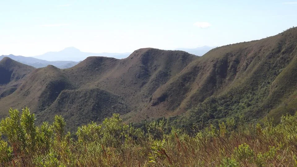
The park spans a geological transition zone between Cerrado - the Brazilian savanna that dominates central Brazil - and Atlantic Forest, the moist eastern biome reduced to fragments. Both ecosystems are present inside the park boundaries, along with something even rarer: rupestrian ferruginous fields, a vegetation type growing on iron-bearing canga crust. This rusty crust, formed by the long weathering of banded iron formations, creates soil chemistry so hostile that only specialized plants can survive on it. In Brazil, canga vegetation exists in only two places: the Iron Quadrangle of Minas Gerais, where Rola-Moça is located, and the Carajás Mountains in faraway Pará. Visits to the canga fields inside the park are allowed only when accompanied by trained park monitors, because the plant communities are both rare and slow to regenerate if damaged. A misplaced hiker's boot can undo decades of growth.
Alpine Tundra in the Tropics
One environmental feature of the park reads like a typographical error. At the highest elevations, there is Alpine tundra - open, cold-adapted vegetation that most observers associate with mountainous temperate zones. In Brazil, at roughly 20 degrees south of the equator, the altitude compensates for the latitude. The highest ridges of the Rola-Moça range sit at around 1,500 meters, high enough for the tropical climate to behave differently, with colder nights, more persistent winds, and plant communities that resemble the high Andes more than the surrounding Atlantic Forest. These high zones also host Orchidaceae and Bromeliaceae - orchid and bromeliad families - along with jacaranda and arnica genera. Specific protected species inside the park include Cariniana legalis, the jequitibá, one of the tallest trees of the Atlantic Forest; Gochnatia polymorpha, a gnarled shrub-tree of the rock outcrops; and Vellozia squamata, a slow-growing plant with trunks that can outlive centuries.
The Endangered List
The animals that still use Serra do Rola-Moça read as a checklist of species that have been pushed off the surrounding landscape. Cougars, the big cats that once roamed most of South America, still hunt inside the park. Ocelots, smaller spotted cats, and oncillas, the smallest of them, both persist here. The maned wolf - tall-legged, solitary, more fox than wolf despite the name - crosses the ridges at night and howls across the valleys. Pampas deer, grassland specialists, feed in the open meadows. The solitary tinamou, a ground-dwelling bird the size of a chicken, nests in the forest floor. Each of these species is threatened across its former range. The park is too small to sustain all of them indefinitely without corridors to other protected areas, but for now, it holds. The proximity to Belo Horizonte - a city of more than two million people within visual distance of the park's ridges - makes that holding more remarkable.
What the Visitor Actually Sees
The park opens at eight in the morning and closes at five in the afternoon. Camping is not permitted. Trails, springs, waterfalls, and nurseries all require advance scheduling, which keeps the visitor load manageable. There are two main entrances: the Nova Lima entrance on the east side, with a visitor center, a 90-person auditorium, and a base for the environmental police; and the Barreiro entrance in Belo Horizonte itself, with a 60-person auditorium and park administration offices. Four lookout points - Três Pedras, Planeta, Jatobá, and Morro dos Veados - provide panoramic views of the metropolitan region and the rolling iron-colored ridges. April through October is the better time to visit, when the rain is less frequent and the trails are passable. In the wet season, from November through March, everything becomes mud, and the view from the lookouts dissolves into gray cloud.
From the Air
Serra do Rola-Moça State Park is centered at 20.04 degrees south, 44.01 degrees west, on the southwestern edge of the Belo Horizonte metropolitan region. The 3,941-hectare park straddles the municipalities of Belo Horizonte, Nova Lima, Ibirité, and Brumadinho. Highest ridges reach around 1,500 m elevation. Recommended viewing altitude 5,000-7,000 ft AGL. The park appears as a forested ridgeline contrasting sharply with the iron mining operations to the east and the urban expansion of Belo Horizonte to the north. Belo Horizonte Pampulha (SBBH) is about 20 km north; Confins (SBCF) is about 40 km northeast. The park is easily visible on approach to either airport from the south. Note the proximity to the Brumadinho tailings dam failure site (2019), a few kilometers southwest of the park.
Nearby Stories
- Inconfidência Mineira 9.8 km away
- Kubitschek Residence Museum 15 km away
- Iron Quadrangle 17 km away
- São Gonçalo do Pará 27 km away
- Morro Velho 32 km away
- Bom Despacho, Minas Gerais 65 km away
- Tiradentes 80 km away
- Our Lady of the Rosary Church, Lavras 102 km away