.jpg)
Isaris
The name most likely comes from the Turkish word for fortress — hisar — and Isaris has spent centuries earning it. Perched amphitheatrically on the eastern slopes of Mount Saint Ilias at 750 meters, the village commands panoramic views across the Megalopolis plain to the northeast and the Messinian valley to the south. Below lie oak groves, chestnut trees, holly, and holm oak; above, bare ridgelines that helped make this place, for centuries before Greece existed, a refuge for klephts and armatoloi — the bandits and armed irregulars who kept resistance alive under Ottoman rule. When the revolution of 1821 finally came, Isaris was ready.
The Hundred Who Held the Church
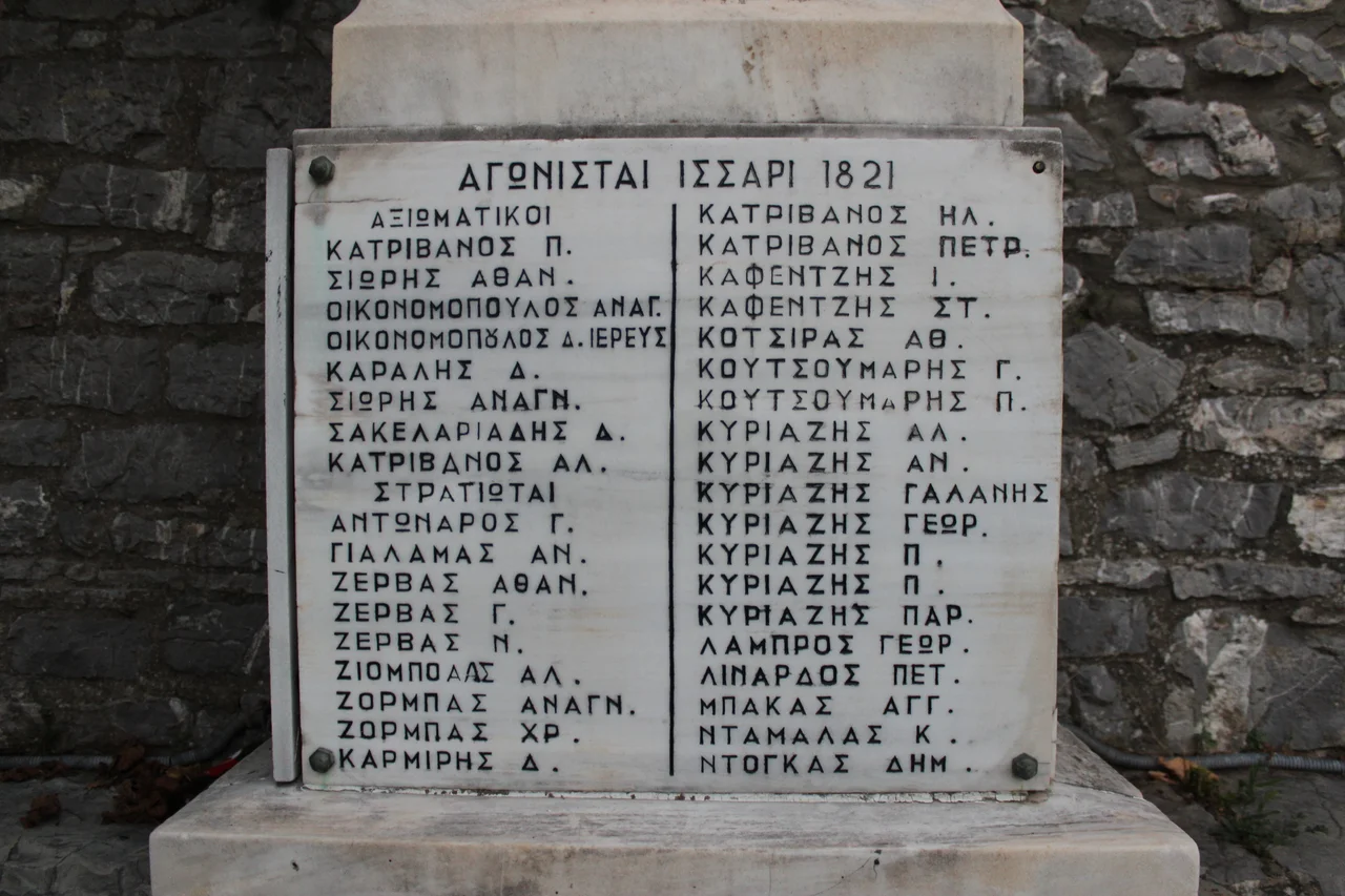
On 7 August 1825, Ibrahim Pasha dispatched 3,500 soldiers to sweep through the western Arcadian highlands. The villagers of Isaris evacuated their women and children first, then barricaded themselves inside the central church of Agios Nikolaos. Their commander was General Athanasios Sioris — born in Isaris in 1756, a veteran of the Battle of Valtetsi, the recipient three months earlier of a personal letter from Theodoros Kolokotronis himself. Fewer than one hundred men faced the approaching force. They held out for the entire day. When the numbers made further resistance untenable, Sioris led a breakout through the enemy lines; several escaped, including the general. The following morning, Ibrahim's Turko-Albanian forces burned what they could not take. The church they had defended was destroyed. The monument in the village's central plaza, erected around 1985, lists the names of more than sixty fighters from that day — officers, soldiers, and those not listed but still remembered.
Before the Revolution: A Stronghold in the Mountains
Isaris appears in the historical record as early as the 1680s, when the Venetian traveler Pier Antonio Pacifico visited the area. The name — almost certainly from the Turkish hisar, meaning fortress — suggests either the village's physical inaccessibility or an actual fortification that once stood here, though which of these came first remains unclear. By the pre-revolutionary decades of the 1770s and 1780s, Isaris had become a documented stronghold for the armed irregulars who operated in the mountains between Arcadia and Messenia. When the War of Independence began in 1821, men from Isaris fought at Valtetsi and elsewhere across the Peloponnese. The most notable were Panagiotis Katrivanos and Athanasios Sioris, whose battlefield careers would carry them from that church in 1825 all the way into Greek military history.
Sons Who Left and What They Carried With Them
By the late 1800s, the rocky terrain that had made Isaris defensible also made it difficult to farm. Incomes were insufficient. Emigration began — a wave that carried Isaraians to the United States, and from there into unexpected places. Yiannis Xirocostas left in 1904, aged fourteen. He studied at the Corcoran School of Art in Washington, became an abstract painter under the professional name Jean Xceron, and eventually took a job as a security guard at the Guggenheim Museum in New York, where he worked for 28 years until his death in 1967. The Smithsonian Archives of American Art described him as a pioneer of non-objective painting; his works are held by the Smithsonian American Art Museum and the Hirshhorn. His family name appears on the village's war monument — the same families who fought in 1825 had grandchildren guarding great art in New York. Another son of the village, Yannis Tsantilis, appeared in Hollywood under the name John Belasco. A later notable, Angelos Koutsoumaris — grandson of the last mayor of nearby Lykosoura — rose to become an Areopagite, Greece's highest judicial rank, and in 1943 attempted to intervene to save 400 Jewish children from Thessaloniki from deportation. His efforts ultimately failed, though research continues into whether some were saved.
From Capital to Quiet
After 1834, Isaris functioned as the capital of the newly established municipality of Lykosoura. It grew into a regional hub: schools, a post office, a gendarmerie station, a justice of the peace. The 1920 census recorded 1,214 residents. Andreas Syggrou — the Athenian financier whose name marks a major boulevard in the capital — donated funds for the village school. A separate girls' school opened in 1890. By 1930, Isaraian emigrants in America funded a new unified school building. But the trajectory was already set. Emigration, urbanization, the pull of Athens: by 1961, the population had fallen to 434. By 2011, it was 86. The school closed in the 1970s. The railway that once connected Isaris to the Athens-Kalamata line, stopping at a station a short distance from the village from 1899 until the 1980s, is also gone. What remains is the church of Agios Nikolaos — rebuilt with marble doors and windows and a gilded iconostasis funded by expatriates — and the monument in the plaza, engraved with the names of those who stayed and fought.
The Plain Below, the Shadow Above
Seven kilometers north of Isaris, the ruins of Lykosoura mark a hill where Pausanias believed the oldest city in the world once stood. To the west, in the village of Vastas, an 11th-century chapel called Agia Theodora draws visitors who come to see the seventeen trees growing directly from its roof — a botanical mystery with no fully accepted explanation. And to the northeast, visible on clear days, the cooling towers of the Megalopolis power plant rise over the lignite mines that have defined that town's modern economy. One of three air-quality monitoring stations for the mine's zone sits in Isaris, measuring whatever drifts upslope from the plain. The studies, as of writing, have reached no firm conclusions. The mountains here have always been both refuge and boundary — keeping the world out, holding the village in, and occasionally letting it burn.
From the Air
Isaris lies at approximately 37.364°N, 22.014°E in western Arcadia, at an elevation of around 750 meters on the eastern slopes of Mount Saint Ilias (also known as Mount Lykaion). Approaching from the air, the village appears as a compact cluster on a south-facing hillside above the broad Megalopolis plain. The cooling towers of the Megalopolis power plant are visible to the northeast and serve as an unmistakable landmark. The nearest major airport is LGKL (Kalamata International), approximately 60 km to the southwest. Recommended viewing altitude is 5,000–8,000 feet for terrain context. Morning light from the east illuminates the village face; afternoon shadows deepen the ravines on the western side.
Nearby Stories
- International Flight Training Center, Kalamata 5.3 km away
- Karyes 6.8 km away
- Barony of Akova 11 km away
- Agios Andreas, Katakolo 13 km away
- Diocese of Amyclae 14 km away
- Larisa (Argos) 19 km away
- 2023 Messenia Migrant Boat Disaster 26 km away
- Panagia Skafidia Monastery 40 km away