Jalapão State Park
The local artisans call it capim dourado - golden grass - and they weave it into rings, earrings, bracelets, and the shimmering baskets that now turn up in Brazilian boutiques from São Paulo to Belém. The grass itself is a flowering plant called Syngonanthus nitens, and it grows almost nowhere except in the wet grasslands of the Jalapão. To find the fields where it ripens, you first have to cross about 600 kilometers of dirt roads. The reward is one of the strangest landscapes in Brazil: red sand dunes rising out of cerrado, flat-topped plateaus sliced by blackwater rivers, and a sky so cleanly separated from the horizon that it becomes its own visual phenomenon.
The Long Drive In
Jalapão is a microregion in the easternmost corner of Tocantins, bordered by Piauí, Maranhão, and Bahia. The state park occupies 158,885 hectares within the municipality of Mateiros, one of the most sparsely populated parts of Brazil. No paved road reaches the park directly. To get there, travelers bump for hundreds of kilometers over rutted dirt roads in four-wheel drive vehicles, crossing rivers on small wooden ferries and wading others in the shallower months. That remoteness is both the park's protection and its principal barrier to visitors. The plateaus - chapadas in Portuguese - rise from flat savanna in steep-walled blocks, their tops bounded by cliffs that the constant action of wind and monsoon rain has been carving for geological ages. Most of the park drains into the upper basin of the Do Sono River, part of the vast Araguaia-Tocantins river system.
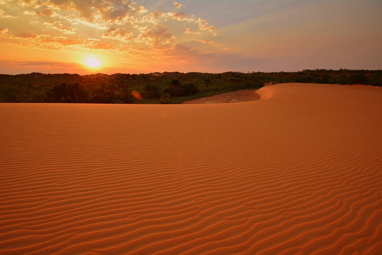
The Red Dunes
At the park's ecological center are the Espírito Santo dunes - a small but distinctive desert of red-orange sand rising in rounded waves amid the otherwise grassy plain. The dunes are fed by sand eroding from a nearby sandstone plateau, blown into shape by the steady Cerrado winds. They rise to perhaps forty meters above the surrounding land, high enough that climbing barefoot through the loose sand takes real effort, and in the late afternoon the sun turns the whole formation into a warm copper color that locals photograph obsessively. The dunes support their own sparse vegetation - a few grasses and small shrubs adapted to mobile sand and year-round heat - and they contrast startlingly with the green that surrounds them. Flying over the park, the dunes register as a small, impossible patch of Martian color in the middle of the savanna.
Cerrado in Every Form
The park's vegetation is a textbook of Cerrado variants. There are dry grasslands and wet grasslands, campo sujo - open grassland dotted with small woody plants - and cerradão, a taller, denser cerrado that verges on forest. Gallery forests line the blackwater rivers in narrow green ribbons. Along seasonal lakes, semi-deciduous vegetation loses its leaves in the dry months. Rare and economically important plants crowd the species lists: cashew relatives, pequi trees, mangaba fruit, and of course the golden grass. Three endemic plants grow here: Acosmium subelegans, Andira cordata, and Parkia platycephala. The hoary fox, Lycalopex vetulus, is a small cerrado canid endemic to this kind of habitat. Two endangered birds - the Brazilian merganser and the Chaco eagle - still find refuge in the park, their populations thin but persistent.
Fervedouros
Scattered across the region are fervedouros - literally "boilers" - natural springs where groundwater rises through quartz sand with such force that it creates a buoyant column no swimmer can sink through. Step into one and you find yourself suspended, floating upright, held by the pressure of water moving up. The sand at the bottom roils visibly. The water stays a steady temperature all year and is so clear you can see your toes ten feet below. The fervedouros have become Jalapão's signature attraction, more widely photographed than the dunes. They are, strictly speaking, just outside the state park, in the surrounding protected landscape, but they are inseparable from any story of the place.
A Corridor, Not an Island
The park was created by state Law 1203 on 12 January 2001 and is administered through agreements with the Nature Institute of Tocantins. It forms the centerpiece of the Jalapão ecological corridor, which includes the Serra Geral do Tocantins Ecological Station - a core zone of the Cerrado Biosphere Reserve - and several smaller protected areas. On 21 July 2009, a cooperative agreement between the federal Chico Mendes Institute for Biodiversity Conservation and the state nature institute established joint management for the corridor. The advisory board for the state park was appointed on 15 December 2011. These administrative details matter because the Cerrado, despite hosting nearly five percent of all species on Earth, receives only a fraction of the protection granted to the Amazon. Jalapão is one of the larger and more intact pieces still standing.
From the Air
Located at 10.27°S, 47.09°W in eastern Tocantins, Brazil. The Espírito Santo dunes are visually striking from altitude - a small patch of red-orange sand within surrounding cerrado. Best viewed from 6,000-10,000 feet AGL during the dry season (May-September) when skies are consistently clear. The nearest significant airport is Palmas (SBPJ/PMW), approximately 300 km west. Access by road is difficult; most visitors fly to Palmas and then drive.
Nearby Stories
- Serra Geral do Tocantins Ecological Station 53 km away
- Nascentes do Rio Parnaíba National Park 61 km away
- Lajeado State Park 88 km away
- Tocantins 101 km away
- Luís Eduardo Magalhães, Bahia 184 km away
- Ilha do Bananal / Cantão Environmental Protection Area 287 km away
- Minaçu 342 km away
- Mirador State Park 405 km away