Karangetang
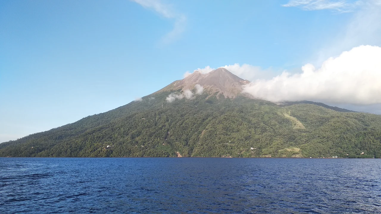
Api Siau. The Fire of Siau. That is what the islanders call Karangetang, and the name is not poetic license. Since 1675, this volcano on the northern end of Siau Island has erupted 41 times, an average of roughly once every eight years for three and a half centuries. It is the tallest mountain in offshore North Sulawesi at 1,827 meters, and it shares its 160-square-kilometer island with over 46,000 people who have made a permanent, if uneasy, peace with living on the slopes of one of Indonesia's most restless volcanoes.
A Volcano That Never Sleeps
Karangetang's eruption record reads like a metronome of destruction. The pattern is relentless: eruptive episodes in 2007 forced evacuations. In June 2009, the Volcanological Survey of Indonesia raised the alert to Level Orange. In August 2010, lava and ash shot hundreds of meters into the air, and four villagers went missing. On 11 March 2011, just hours after a magnitude-9.0 earthquake in Japan triggered a Pacific-wide tsunami, Karangetang erupted again, as if answering seismic chaos with volcanic chaos. September 2013 brought another eruption. November 2018 brought another. July 2019 brought another, this one accompanied by lava effusion that continued for months. Between eruptions, dense white steam plumes rise as high as 300 meters from the main crater, a constant reminder that the fire has not gone out.
The Geography of Risk
Siau Island is not large. At 160 square kilometers, it is roughly the size of a mid-sized city. Karangetang dominates the northern half, its slopes dropping steeply to the coastal villages where the majority of the island's population lives. The proximity is the problem. Pyroclastic flows, the superheated avalanches of gas, ash, and rock that represent a volcano's most lethal weapon, can travel faster than any vehicle on Siau's roads. In 1997, a pyroclastic flow from Karangetang killed three people. The terrain offers few escape routes; the sea is the only reliable one. Every eruption triggers the same grim choreography: alert levels rise, evacuation orders go out, boats arrive to carry people to safety on neighboring islands or the Sulawesi mainland.
Science Watches the Crater
The Volcanological Survey of Indonesia monitors Karangetang continuously, tracking seismicity that reveals the movement of magma beneath the surface. During periods of heightened activity, seismographs record earthquakes indicating lava effusion from the southwest side of the main crater, along with tremors associated with avalanches of unstable material cascading down the slopes. The monitoring data paint a picture of a volcano in perpetual negotiation between pressure and release. Lava domes grow, oversteepen, and collapse. Gas plumes vent pressure that might otherwise build to explosive thresholds. The scientists watching Karangetang are not trying to predict when it will erupt; they are trying to determine how bad the next eruption will be.
Living with the Fire
Despite everything, Siau's population has grown, from 40,758 in the 2010 census to an estimated 46,459 in mid 2023. People stay because Siau is home, because the volcanic soil grows excellent cloves and coconuts, because the fishing is good, and because leaving means abandoning everything familiar for uncertain prospects in Manado or beyond. The relationship between the islanders and their volcano is not one of ignorance. They know what Karangetang can do. They have buried neighbors, rebuilt homes, and evacuated by boat in the middle of the night. They also know that the mountain provides the fertile soil that sustains them, and that the island they love exists only because the volcano built it. Api Siau, the Fire of Siau, is both destroyer and creator. The people of Siau live within that contradiction, because there is no other choice.
From the Air
Located at 2.778N, 125.408E on the north end of Siau Island in the Sangihe Islands chain. CRITICAL: One of Indonesia's most active volcanoes with frequent eruptions. Always check NOTAMs for volcanic ash advisories and exclusion zones. The conical peak at 1,827 m is the dominant visual feature of Siau Island. Sam Ratulangi International Airport (ICAO: WAMM) in Manado is approximately 170 km to the south-southwest. Nearby volcanic islands include Ruang to the south and Sangihe to the north. Steam plumes frequently visible from altitude. Avoid flying directly over the crater.
Nearby Stories
- Mount Ruang 18 km away
- Sangihe Islands 19 km away
- Bunaken National Park 90 km away
- Bunaken 123 km away
- USS Shark (SS-174) 174 km away
- Japanese Minelayer Tsugaru 237 km away
- 1913 Sulawesi-Mindanao Earthquake 284 km away
- Basilan 503 km away