La Calera, Cundinamarca
The name is a Latin root that means to burn, to blaze, to flame. Calera is what you call a kiln where stone is burned into lime. The town called La Calera, eighteen kilometers east of Bogota, is named for what it did to rocks for four centuries. Indigenous Muisca workers brought limestone down from the Teusaca mines to kilns scattered across the Sabana de Bogota. The Spanish came and took over the kilns. Then came cement, cemented onto the town's identity so thoroughly that when the Samper cement company shut down and left in 1998, La Calera did not know what else to do.
Teusaca Before La Calera
Before any Spaniard saw this valley, the Muisca people lived here in three communities: Teusaca near the present town, Suaque, and Tunjaque in what is now the Mundo Nuevo area. The Muisca were one of the four great civilizations of pre-Columbian South America, organized in a confederation that covered much of the Colombian high plains. The place name Teusaca survives on the river that crosses the municipality. Historians have argued about what the word meant. Some translate it as prison. Joaquin Acosta Ortegon suggested borrowed enclosure. Either reading hints at confinement. In 1563, the encomienda of Teusaca was granted to Juan Ruiz Clavijo, Spanish conquistador and beneficiary of a labor system that amounted to forced tribute from Indigenous communities. By 1597 Teusaca's native village had emptied. In 1604, the colonial official Lorenzo de Terrones gathered 359 Indigenous people from Teusaca, Suabso, Tabtiba, Suto, and Tuchasgula and consolidated them into a smaller colonial settlement. The original Muisca geography had been rewritten.
The Haciendas of the Clavijos
The Clavijo family held La Calera for generations. The story begins with Cristobal Ruiz Clavijo, a conquistador who served under Gonzalo Jimenez de Quesada, the founder of Bogota. His descendants built and expanded the Hacienda La Calera, whose lime kilns gave the future town its name. When the Clavijo line eventually sold the property to Joseph Salvador Ricaurte, and then the estate passed to Pedro de Tovar y Buendia in 1765, the shape of the settlement changed. The Tovar y Buendia family helped establish the parish of Nuestra Senora del Rosario around which the town formally consolidated. December 16, 1772 is recognized as the founding date of La Calera. The town spent the next century trying to figure out what kind of municipality it wanted to be. It was dissolved into Bogota in 1850. Reinstated in 1851. Elevated to village status in 1853. By the twentieth century it had settled into being the lime town next to the capital.
Cement That Employed Three Thousand
La Calera's economy centered on a single company for most of the twentieth century. Samper Cement employed roughly three thousand people directly and indirectly, a massive share of the town's population. The limestone that had been burned into lime for centuries was now fed into industrial kilns to make cement that paved and built the capital below. When Samper relocated in September 1998, La Calera was unprepared. The company's departure left behind economic stagnation that lingered for years. Local authorities had not diversified the economy. The old quarries stood silent above the valley. Cemex eventually took over cement operations on a smaller scale. Coca-Cola's Manantial water bottling plant moved in. But the transition was painful and incomplete, and anyone who lived through it in La Calera remembers both the Samper years and the sudden quiet that followed.
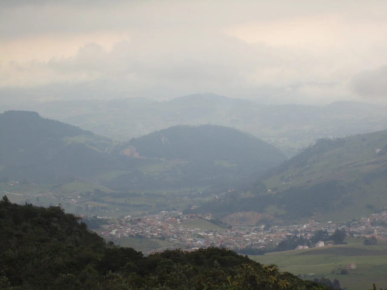
The Water Towns Above the City
La Calera sits between 2,600 and 3,000 meters above sea level, crossed by the Cruz Verde ridge of the Eastern Andes. The Teusaca River begins in the Laguna del Verjon near Bogota's famous Monserrate hill and flows north through the municipality to meet the Bogota River at Sopo. The Rio Blanco starts at Laguna de Buitrago and gathers a constellation of smaller streams before joining the Rio Negro. Within the municipal boundary lies the San Rafael Reservoir, which supplies water to Bogota's aqueduct system, and the municipality connects to the Chuza Reservoir, fed by the Chingaza Lagoon in neighboring Fomeque. La Calera provides much of Bogota's drinking water. The enormous Chingaza National Natural Park, a paramo of high-altitude tundra that sustains the reservoirs, is accessed through the municipality. Water has replaced cement as the resource that binds La Calera to the capital below.
Weekends from Bogota
For residents of Bogota, La Calera is the nearest place to escape. The drive takes roughly forty minutes from Chapinero via Avenida Circunvalar and the Los Patios Toll, climbing east over the Eastern Hills through a gap in the ridge. The town itself sits in a valley of clubs, country houses, and weekend restaurants. Paragliders launch from hillsides above the San Rafael Reservoir on clear days, drifting down toward Bogota's skyline to the west. Mountain bikers ride the back roads. Hikers strike out for trails through the paramo. Farmers' markets sell organic vegetables: potatoes, corn, the Andean tuber called cubio, carrots. Wool textiles, wicker furniture, and wood carving are still made by local hands. La Calera's shift from an industrial mining town to a weekend destination is not complete, but it is underway, driven by Bogota's relentless hunger for somewhere cooler and greener than itself.
Who Came From Here
Israel Corredor, the cyclist who represented Colombia internationally, was born in La Calera. So was Amadeo Rodriguez Vergara, a Conservative general who served as a congressman from Bogota and fought in the 1932-1933 war against Peru over border territories. Rodriguez Vergara became mayor of La Calera during the Bogotazo, the 1948 uprising that followed the assassination of populist leader Jorge Eliecer Gaitan and set off a decade of civil violence known as La Violencia. He later served as Colombian Consul in Barcelona and is mentioned, in passing, by Mario Vargas Llosa in his novel The Dream of the Celt. The town library is named for him. Not many Colombian towns of twenty-five thousand people can claim both a professional cyclist and a nobel-laureate cameo. La Calera collects its history the way it once collected limestone. Quietly, and for a long time.
From the Air
Located at 4.72 degrees North, 73.97 degrees West, in the Guavio Province of Cundinamarca, Colombia. La Calera sits in the Teusaca River valley at 2,600 to 3,000 meters elevation, directly east of Bogota (4.71 N, 74.07 W). The capital is 18 km away over the Cerros Orientales (Eastern Hills). Nearest airport: El Dorado International (SKBO) at Bogota, 25 km west. Chingaza National Natural Park extends east and south from the municipality, protecting paramo ecosystems above 3,200 meters. Recommended viewing altitude: FL150 to FL200 for the full Sabana de Bogota with La Calera perched on its eastern rim; the San Rafael and Chuza Reservoirs are visible as linear blue shapes in the mountains. Afternoons often bring mountain weather and reduced visibility; early flights offer the cleanest view.
Nearby Stories
- Zipaquirá 11 km away
- Villavicencio 50 km away
- Tunja 70 km away
- Tolima Department 88 km away
- Valle de Cocora 103 km away
- Manizales 110 km away
- Battle of Vargas Swamp 128 km away
- Operation Jaque 282 km away