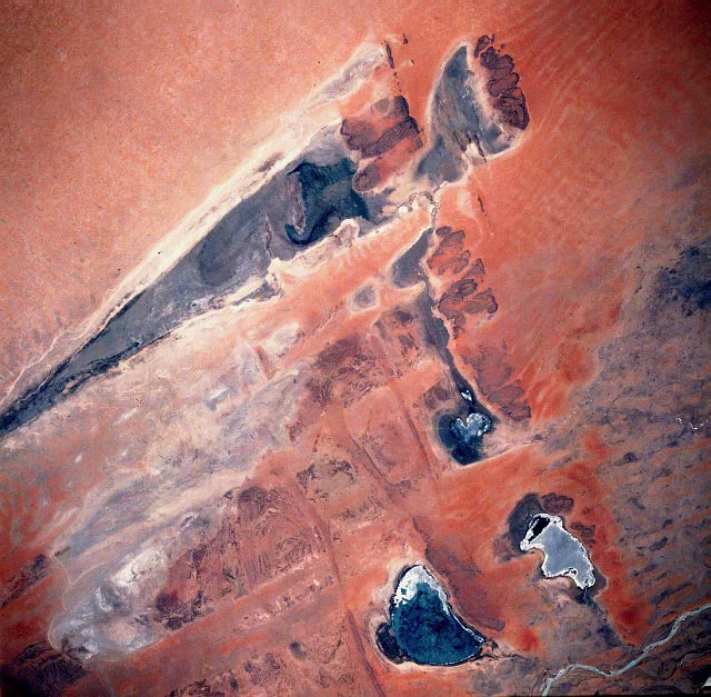

Lake Faguibine
There are people in the villages near Timbuktu who remember when Lake Faguibine was full - when fishermen worked its waters, crops ringed its fertile shores, and cattle grazed its margins through the dry season. Their grandchildren have never seen it. At 590 square kilometers, Faguibine was once among the largest lakes in West Africa. Today it is mostly bare ground, and in 2021 it was entirely dry: a vast empty basin where a gas seeping from the cracked earth now poisons what little vegetation tries to take hold.
The Long Road of Water
Faguibine never filled itself. It sat at the far end of an intricate 170-kilometer plumbing system fed by the Niger River, 80 kilometers west of Timbuktu and 75 kilometers north of the river itself. Floodwater branched off the Niger through the Kondi and Tassakane channels, wound across floodplains, filled Lake Télé and then Lake Takara, and only then - once both were brimming - spilled over a rocky sill at Kamaïna and ran west to reach Faguibine. To fill the lake completely took about 4 cubic kilometers of water, nearly a fifth of the Niger's average annual flow. Everything depended on a flood high enough to complete that long, fragile journey.
When the Floods Failed
The Niger's flood was always a gamble. In strong years - between 1924 and 1930, and again from 1951 to 1955 - the lake filled to the brim. In weak years it could dry out entirely, as it did in 1914, 1924, and 1944. Then came the great Sahel drought of the late 1970s, and the failures stopped being occasional. The annual flood arrived too low, too rarely, to push water all the way to Faguibine. Dams upstream, like the Sélingué on the Sankarani River, held back floodwater that once reached the lake. With each dry year, the vegetation that anchored the surrounding dunes died, and the loosened sand blew into the very channels that carried the water - the drought feeding on itself.
What the Drought Took
The collapse was not only ecological; it was human. Where families had fished and farmed, the land turned to desert, and many had no choice but to leave. The Tuareg Rebellion of the early 1990s interrupted one early effort to restore the channels. Yet people kept fighting for the lake. Since 2002, villages have banded together to dig the drifting sand out of the sill at Kamaïna - in October 2008 alone, around a thousand people worked for six days to clear it. The Malian government created an office in 2006 to maintain the channels and replant the dunes, and aid organizations from Germany, Norway, and the World Food Program have all tried to coax the water back.
The Ideal That Was Never Excess
There is a quiet irony in Faguibine's story. The farmers here never wanted the lake at its fullest. Their ideal was a lake only partly filled - shallow enough to plant crops around its rim and grow bourgou grass for dry-season pasture, a state that needed just half a cubic kilometer of water rather than four. Modest, achievable, sustaining. That this gentler ambition has slipped beyond reach measures how far the climate of the southern Sahara has shifted. Faguibine is a lake on the maps and in memory, an emptiness on the ground - a place where the Sahara, year by year, has been winning.
From the Air
Lake Faguibine lies near 16.75°N, 4.0°W, about 80 km west of Timbuktu on the southern edge of the Sahara. For most flights it will appear not as a lake but as a pale, dry basin roughly 590 km2 in extent, fringed by dunes - water is present only in rare high-flood years. The feeder channels and the smaller lakes Télé and Takara trace a line southeast toward the Niger River. Nearest airport is Timbuktu (GATB) to the east; Mopti (GAMB) lies farther southwest. Best viewed from cruising altitude in clear weather; harmattan dust can obscure the basin from December through February.
Nearby Stories
- Djinguereber Mosque 54 km away
- Tondidarou 57 km away
- Liptako 118 km away
- Sangha, Mali 230 km away
- Dia, Mali 245 km away
- Oualata 262 km away
- French West Africa 281 km away
- Festival au Désert 343 km away