.jpg)
Lake Tight
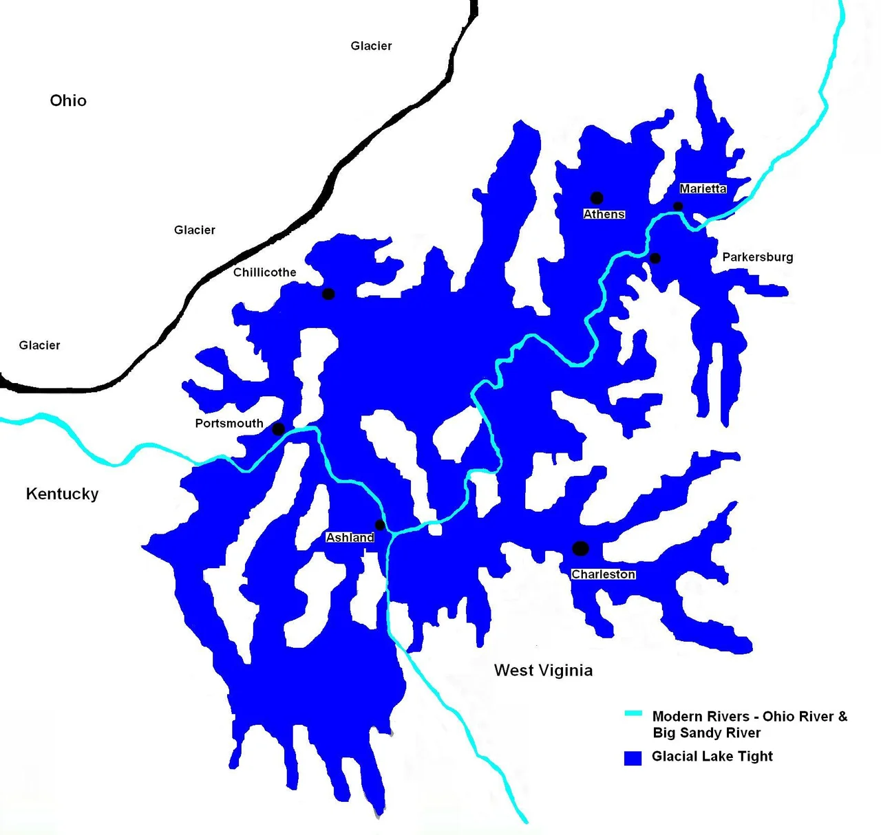
Stand on a ridge in southern Ohio today and you are looking out over what used to be a lake bed. About a million years ago, an Ice Age glacier crept south from Canada and dammed a major river called the Teays. The dammed water backed up into a Pleistocene-era inland lake nearly the size of modern Lake Erie - 900 feet deep, perhaps 10,000 square miles in area, spilling across what is now Ohio, Kentucky, and West Virginia. The lake did not last long in geological terms. But when it finally overflowed, it carved new south-flowing drainage channels that eventually became the Ohio River. Almost everything geologically interesting about the modern eastern United States happened downstream of Lake Tight.
The River Before the Lake
The Teays River was the dominant drainage of the eastern interior for several million years before the Pleistocene. It rose in the Appalachian Mountains in what is now North Carolina and flowed north and west across what is now West Virginia, Kentucky, Ohio, Indiana, and Illinois before emptying into the Gulf of Mexico. The Gulf in those days extended much farther north than it does today, reaching into southern Illinois. The Teays drained an enormous watershed and was probably wider and more powerful than the modern Ohio. Its valley still exists, buried under glacial sediment, traceable through well logs and the occasional surface remnant. Sometimes geologists call it Ohio's ancient Nile.
When the Glacier Came
When the Pre-Illinoian glaciation pushed south during the early Pleistocene, the advancing ice front blocked the Teays drainage. Water cannot flow uphill, so the river backed up into the spaces it could find - low ground, tributary valleys, broad basins south of the ice front. The resulting lake formed around what is now Chillicothe, Ohio, but spread far beyond it. Earlier estimates put the surface area at about 7,000 square miles. A 2014 GIS study using USGS elevation data revised that upward to roughly 9,940 square miles. A 2018 reconstruction by James L. Erjavec, refining John Wolfe's 1942 mapping work with a 275-meter contour model, put the figure at about 10,040 square miles, with a volume of around 268 cubic miles. At its peak, Lake Tight was as large as Lake Erie.
What the Clays Remember
The lake left behind a distinctive sediment called the Minford Silt Member of the Teays Formation. This silt accumulated on the lake floor over centuries, preserving the lake's footprint in subtle layered deposits that geologists can still map today. Critically for dating, the silt records reverse magnetic polarity. Earth's magnetic field has flipped many times throughout geological history, and the last reverse-polarity period ended about 780,000 years ago. Lake Tight's reverse-polarity clays put the lake's existence before that boundary, in the early or middle Pleistocene. The lake formed when there was still no such thing as a modern human - the genus Homo had only just begun to emerge in Africa, and our species would not appear for hundreds of thousands of years.
The Outflow That Made the Ohio
Lake Tight did not last forever. When the water rose high enough to find a southern outlet, it began to drain - probably catastrophically at first, then steadily over decades and centuries. The escaping water carved new southerly drainage channels across the soft sediment of the lake basin. Those channels evolved into the modern Ohio River system, flowing south and west instead of the Teays' old north-and-west route. The Ohio that floats barges past Cincinnati and Louisville today is a direct descendant of Lake Tight's outflow. The original Teays watershed lies buried beneath glacial debris, occasionally betraying itself in unusual modern stream patterns or in the strange topographic features that mark the lake's old shoreline. The geologist William G. Tight, for whom the lake was named, first recognized the buried Teays valley in the early 1900s. He could not have imagined that GIS technology a century later would let his successors map the lake he gave his name to with kilometer-scale precision.
From the Air
Lake Tight's coordinates 38.80 N, 82.21 W mark a point in the lake's southern basin, near the Ohio-West Virginia border south of Gallipolis. The lake at its peak covered much of southern Ohio, northern Kentucky, and the Kanawha drainage in West Virginia. John Glenn Columbus International (KCMH) and Yeager Airport (KCRW) both lie within the former lake basin. Best viewed at 8,000-15,000 feet, when the broad rolling lowlands of the former lake bed stand out against the surrounding Appalachian ridges.
Nearby Stories
- Ashland, Kentucky 2.7 km away
- Salt Reservations 3.1 km away
- Wayne National Forest 4.5 km away
- Morris Memorial Hospital for Crippled Children 8.5 km away
- Mount Zion Baptist Church 17 km away
- Robey Theatre 19 km away
- Malden, West Virginia 22 km away
- Jesse Stuart Memorial Bridge 25 km away