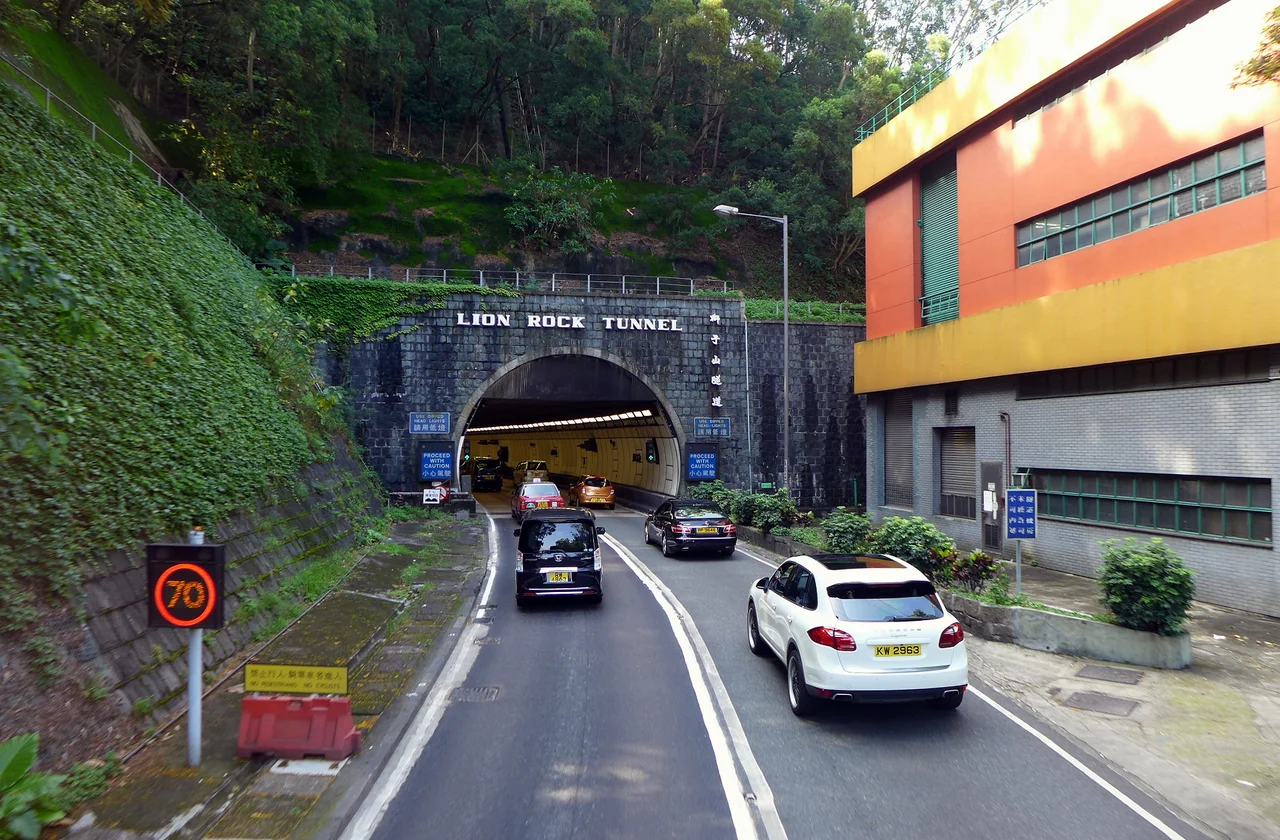

Lion Rock Tunnel
It began as a footnote to a water project. When engineers bored the Plover Cove supply tunnel through the hills separating Kowloon from the New Territories in the early 1960s, the government saw an opening — literally — to thread a road through the same granite ridge. On 14 November 1967, the Lion Rock Tunnel opened, and Hong Kong's relationship with its own hinterland changed permanently. What had been a slow, winding approach to the northern new towns became a straight shot through 1.43 kilometres of ancient rock.
Bored from an Accident of History
The Lion Rock Tunnel was never the main event. The Plover Cove Scheme — Hong Kong's ambitious attempt to dam a sea inlet and turn it into a freshwater reservoir — required a tunnel through the granite range above Kowloon. Civil engineer Young Au Young, a Lingnan University graduate, saw that the alignment opened the possibility of a parallel road bore. The construction started in January 1962 and the tunnel opened in November 1967 as a 1.43-kilometre dual-carriageway in a single bore. It was Hong Kong's first major road tunnel, predating by decades the network of harbour crossings and hill tunnels that would define modern Hong Kong infrastructure.
The granite it cuts through is old — Kowloon granite, estimated at around 140 million years in age. The mountain above the tunnel is the same rock that gives Lion Rock its unmistakable silhouette. Drivers passing through the tiled walls twice daily rarely consider they are passing beneath something formed in the Jurassic.
A Second Bore for a Growing City
By the mid-1970s, the New Territories was no longer rural hinterland. The Hong Kong government was building Sha Tin as a new town, and the single bore was struggling to handle traffic in both directions. On 18 January 1978, the Second Lion Rock Tunnel opened to the west of the original, at 1.41 kilometres in length and running parallel throughout. The arrangement settled into the pattern still in use today: the original bore carries southbound traffic towards Kowloon, the newer bore carries northbound traffic towards Sha Tin. When one tube goes offline for maintenance, both directions of traffic share the remaining bore — a managed inconvenience that Hong Kong commuters know well.
The two tunnels together form a vital link on Route 1, the trunk corridor connecting the urban core of Kowloon with the northern new towns. Their combined daily flow routinely exceeds 90,000 vehicles, the highest of any non-harbour-crossing tunnel in Hong Kong.
Ninety Thousand Vehicles a Day
Numbers tell part of the story. In 2014, an average of 90,608 vehicles used the Lion Rock tunnels every day. That figure reflects something about Hong Kong's geography as much as its traffic engineering: the mountains that divide Kowloon from the New Territories are a genuine barrier, and the tunnels are the needle that threads it. Other tunnels — Shing Mun, Tate's Cairn, eventually Tsing Sha Highway — drew traffic away from Lion Rock as they opened, and yet the congestion only redistributed rather than disappeared.
The HK$8 toll (each way) is deliberately kept below the rate of the Tate's Cairn Tunnel, which offers an alternative route to the same destination. The lower fare, combined with the directness of the route, explains the volume. For most drivers heading from Kowloon Tong to Sha Tin, the Lion Rock tunnel is simply the obvious choice.
Renovation and the Life of Infrastructure
Tunnels age from the inside. By 2008, the facilities within both bores had deteriorated seriously — cracked concrete on the road surface, corroded fire-resisting shields on the walls, worn ceiling linings. The Highways Department initiated renovation works intended to extend the life of both tubes by approximately 80 years. The maintenance required one-tube-two-way operation, which the department managed by shifting the start time for single-tube traffic, sometimes pushing it earlier into the evening to reduce peak-hour disruption.
Through all of this, one detail was preserved as a deliberate choice: the words LION ROCK TUNNEL — and their Chinese counterparts — would remain on the sides of the entrances and exits. The signage is part of the place's identity now. Whether you are heading north toward Sha Tin's new towns or south toward the dense streets of Kowloon City, those letters mark a threshold that generations of Hong Kong residents have crossed without thinking about it, until they stop to look.
Under the Lion's Belly
The tunnel passes beneath Lion Rock Country Park, beneath the mountain whose silhouette has become an emblem of Hong Kong resilience. Above you, as you drive, the granite ridgeline rises to 495 metres — the same stone that hikers clamber toward the lion's head, that Qing Dynasty villagers walked around on old paths cut through the hills. The tunnel is not a monument to any of that. It is a utilitarian infrastructure project, designed to move people efficiently.
But that efficiency has its own significance. The hundreds of millions of journeys made through these bores represent the daily life of a city that rebuilt itself from postwar poverty into one of the world's most densely connected urban places. The tunnel doesn't celebrate that story. It simply enables it.
From the Air
Lion Rock Tunnel lies at approximately 22.3558°N, 114.173°E, piercing the granite ridge that separates urban Kowloon from the Sha Tin valley. From the air at 3,000–5,000 feet, the tunnel portals are visible at the base of the Lion Rock ridgeline — look for the highway scar cutting south from Sha Tin into the mountains, with the distinctive lion-profile summit above. Hong Kong International Airport (VHHH) is approximately 30 km to the west-southwest. The northern portal opens onto the Sha Tin new town grid; the southern portal emerges near Kowloon Tong, identifiable by the MTR interchange visible from above. Beacon Hill (457 m) with its civil aviation tower sits immediately to the west. Visibility through this mountain corridor can be affected by the low cloud and mist that frequently wrap the ridgeline in the wet season months.
Nearby Stories
- Chapel of St. Francis Xavier 3.5 km away
- Cuiheng 4.1 km away
- 2015 Shenzhen Landslide 16 km away
- Shunde 31 km away
- Wanshan Archipelago 37 km away
- Nanxiong Formation 96 km away
- Heyuan 149 km away
- Checheng Fu'an Temple 629 km away