
Louisburgh, County Mayo
Louisburgh, a small town on the southwest corner of Clew Bay in County Mayo, has an unusually specific origin story. It did not grow up around a river crossing or a market or a monastery. It was built, on purpose, in 1795, by John Denis Browne, the 3rd Earl of Altamont, later the 1st Marquess of Sligo, to give shelter to Catholic refugees fleeing sectarian violence in the north of Ireland. The name has nothing to do with County Mayo and everything to do with a French fortress on Cape Breton Island in Nova Scotia, where Browne's uncle had fought for the British thirty-seven years earlier. It is a town whose name carries a war fought across the Atlantic, attached to a place built for people running from another war at home.
A Town with a Map
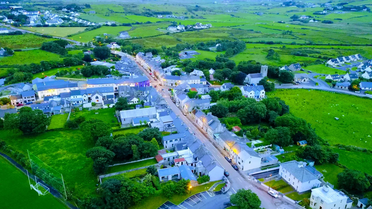
Most of Louisburgh sits within the townland of Clooncarrabaun, an anglicisation of the Irish Cluain Cearban. Unlike the organic Irish villages around it, Louisburgh was a planned town, drawn before it was built. The grid and scale survive today, giving the place an unusual coherence: streets that go where they were meant to, blocks that match in proportion, the eighteenth-century geometry visible to anyone walking through. Browne built it for Catholic refugees displaced by violence further north, a notable gesture from an Anglo-Irish landlord in a period when sectarian tensions were tightening. The town he founded became the largest settlement in this corner of Mayo and remains one of the most distinctive in its layout.
Why It Was Called Louisburgh
The naming is the kind of family history that gets repeated until it becomes part of the landscape. In 1758, during the Seven Years' War, a British force besieged and captured the French fortress of Louisbourg on Cape Breton Island in what is now Nova Scotia. The victory was significant enough that a temporary military unit was formed in its honour, the Louisbourg Grenadiers. Captain Henry Browne, John Denis Browne's uncle, served as a captain in that unit. When Browne built his planned town in Mayo nearly forty years later, he named it after the Canadian fortress where his uncle had fought. The anglicised spelling, Louisburgh, replaced the French Louisbourg, but the link is direct.
Beaches and the Holy Mountain
Louisburgh sits at a particular intersection of geographies. To the east rises Croagh Patrick, Ireland's holy mountain, visible from the town. To the south stretch the Sheeffry Hills and the Mweelrea Mountains. To the west, the Atlantic and a coastline of beaches whose cleanliness has become a local point of pride. Old Head, Bunowen, and Carramore lie closest. Further out are Carrowniskey, Cross, and Lecanvey, and beyond them the famed expanses of White Strand of Tallabawn, Silver Strand, and Uggool Beach. Roonagh Pier, six kilometres from the town, is where the ferries leave for Clare Island and Inishturk. The town serves as a gateway both to the mountains behind and to the islands offshore.
Granuaile and Notable Sons
Louisburgh is home to the Granuaile Interpretive Centre, dedicated to Grainne O'Malley, the sixteenth-century pirate queen who controlled the waters around Clew Bay during the reign of Elizabeth I. The connection runs deep in local identity. The town has also produced its share of notable figures: James Berry, the nineteenth-century writer; Mike McCormack, the contemporary novelist whose work has earned international recognition; John Heneghan, a Columban missionary who was kidnapped and killed by Japanese forces in the Philippines during the Second World War; Michael Viney, the Irish Times columnist who chronicled the natural history of this coast over decades; and John McEvilly, archbishop. For a town of its size, the roll call is striking.
Drama on Bank Holidays
Every May Bank Holiday weekend, Louisburgh hosts Feile Chois Chuan, a traditional music festival that draws enthusiasts from across Ireland and beyond. The town also has an unusual theatrical history. Since 2006, the drama society Ceol agus Drama i gCluain Cearban, founded to focus on children's theatre, has produced an annual pantomime. The list reads like a Christmas catalogue: Dick Whittington in 2006, Cinderella in 2007, Aladdin in 2008, Snow White in 2009, Robin Hood in 2010, Hansel and Gretel in 2011. The proceeds went to local causes including the Order of Malta. For a town of fewer than 500 people, the pantomime tradition speaks to the determined cultural life of a small Irish community.
From the Air
Coordinates: 53.7667 N, 9.8167 W. Louisburgh sits 18 km west of Westport on the R335 regional road, on the southwest corner of Clew Bay. From the air, the planned grid is unusually crisp for a town of its size, with the Bunowen River curving past on the south side. Croagh Patrick rises 16 km to the east and dominates the eastern view. Nearest airports: Ireland West Knock (EIKN) about 55 km east, Galway (EICM, GA only) about 90 km southeast. Recommended viewing altitude 2,500 to 4,000 ft. Atlantic weather here can change in 15 to 20 minutes.
Nearby Stories
- Annaghdown 6.9 km away
- Claremorris 9.4 km away
- Inishbofin Island 9.9 km away
- Attymass 10 km away
- Ballycroy 11 km away
- Toombeola 13 km away
- Blackrock Island, County Mayo 14 km away
- RMS Carinthia (1925) 40 km away