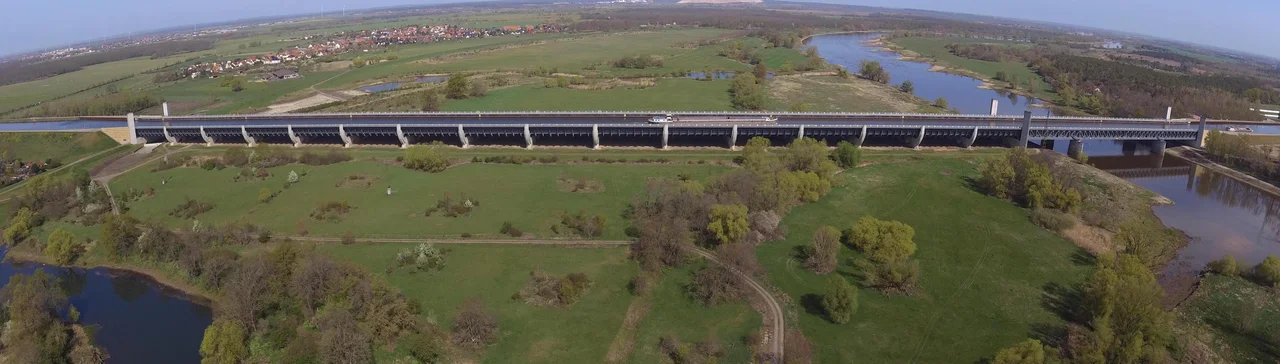

Magdeburg Water Bridge
Work on the project started in 1905. It finished in 2003. In between, the German state that commissioned it collapsed, a second one built most of it, a third abandoned it as pointless, and a fourth decided it was urgent again. What they eventually built is a canal that flies. The Magdeburg Water Bridge carries the Mittelland Canal over the top of the river Elbe on 918 metres of steel trough — 690 metres of it across land, 228 metres across open water — and delivers the barges to the Elbe-Havel Canal on the far bank without their ever descending into the river at all. From a boat's deck the sensation is quietly absurd: you are steering through farmland, then over a treeline, and then there is a broad brown river well below the hull, going the other way.
The Problem With Rivers
Two great canals meet at Magdeburg. The Mittelland Canal comes in from the west, from the Rhineland ports; the Elbe-Havel Canal runs east to Berlin's inland harbours. For most of the twentieth century they simply did not connect. They arrived at opposite banks of the Elbe at a substantially higher level than the river, which meant that a barge crossing between them had to be locked down into the Elbe, work its way along, and then be locked back up on the other side — an awkward, slow zigzag detour of some twelve kilometres, and one that put fully loaded commercial traffic at the mercy of whatever the Elbe happened to be doing that week. Rivers are not obedient. Canals are. The whole point of the water bridge is that the canal never has to negotiate.
A Project the Cold War Forgot
Planning for a crossing here goes back to at least the start of the twentieth century, and work on the Mittelland Canal itself began in 1905. Construction on the wider scheme ground on for decades and stopped dead in 1942, when the Second World War took the steel and the men. After the war the calculation changed completely. The government of East Germany, which now held this stretch of ground, saw no reason to resume: east–west trade was precisely what the Cold War existed to prevent, and a bridge designed to carry Rhineland cargo to Berlin was an answer to a question nobody in the GDR was asking. So it sat, half-imagined, for another half-century. Reunification revived it overnight. With the water routes between western Germany and Berlin suddenly worth rebuilding, work restarted in 1998, took six years, and cost €501 million.
Twenty-Four Thousand Tons of Steel
The finished structure holds 24,000 tons of steel and 68,000 cubic metres of concrete. The trough is 34 metres wide and holds water 4.25 metres deep — enough for the large commercial vessels that use the route, not a scenic novelty. Its longest single span reaches 106 metres across the Elbe's navigation channel. It opened on 10 October 2003, and it is generally credited as the longest navigable aqueduct in the world. Here is the counterintuitive part, and it is pure Archimedes: the loaded barges make no difference to what the bridge carries. A floating vessel displaces exactly its own weight in water, so a laden freighter pushes aside exactly its own weight in canal, and that displaced water simply flows away along the trough in both directions. The bridge holds the same mass whether it is empty or nose-to-tail with shipping. Engineers have known this since antiquity. It still looks wrong.
The Staircase at Hohenwarthe
A bridge alone would not have solved the problem, because the two canals it joins do not sit at the same height. On the eastern side, at Hohenwarthe, a double lock was built to lower vessels from the level of the water bridge and the Mittelland Canal down to the Elbe-Havel Canal — a drop of roughly eighteen metres, handled in a pair of chambers. Together the bridge, the locks and the associated works make up the Wasserstraßenkreuz, the waterway crossing: an interchange for ships, laid out with the same logic as a motorway junction, in the middle of the Saxony-Anhalt countryside. It is a strange thing to come across on a walk. The towpaths are open, and from the parapet you can watch a barge slide past at eye level with the tops of the trees.
The Cameo
The bridge has acquired a modest second career as scenery. It appears in the 2011 film Hanna, about seventy-five minutes in, and in the film Vitou the Kong — which is roughly the treatment you would expect for a structure whose main quality is that it looks impossible. Photographs of it circulated online for years with captions insisting it was a hoax, and the Snopes photo gallery still carries an entry confirming that no, there really is a canal over the Elbe. That may be the truest measure of the thing. A ninety-eight-year construction schedule, four German governments, a war and a Cold War produced an object that most people, on first sight, assume is fake.
From the Air
The water bridge crosses the Elbe at 52.231°N, 11.702°E, about 10 km north of Magdeburg near Hohenwarthe in Saxony-Anhalt. It is one of the most legible man-made features in the region from the air: a dead-straight ribbon of water running east–west, stepping over the meandering Elbe at right angles, with the pale concrete trough and its approach embankments standing clear of the surrounding farmland. Best appreciated at 1,500–3,000 ft AGL — high enough to see the canal continue on both banks, low enough to register that the two waterways are at different levels. The Hohenwarthe double lock lies just east of the crossing and reads as a pair of long rectangular chambers. Nearest fields are Magdeburg City (EDBM) a few kilometres south, Magdeburg-Cochstedt (EDBC) to the south-west, Berlin Brandenburg (EDDB) about 120 km east, and Leipzig/Halle (EDDP) to the south-east. Flat terrain throughout; morning fog forms readily over the Elbe valley in autumn, and the low winter sun off the canal surface makes the structure exceptionally photogenic from the south.
Nearby Stories
- Helmstedt–Marienborn border crossing 15 km away
- Inner German Border 18 km away
- Ströbeck 24 km away
- Friesack Camp 26 km away
- All Saints' Church, Wittenberg 29 km away
- Bauhaus Dessau 38 km away
- Holy Blood of Wilsnack 46 km away
- Stones Fan Museum 46 km away