
Mai Po Marshes
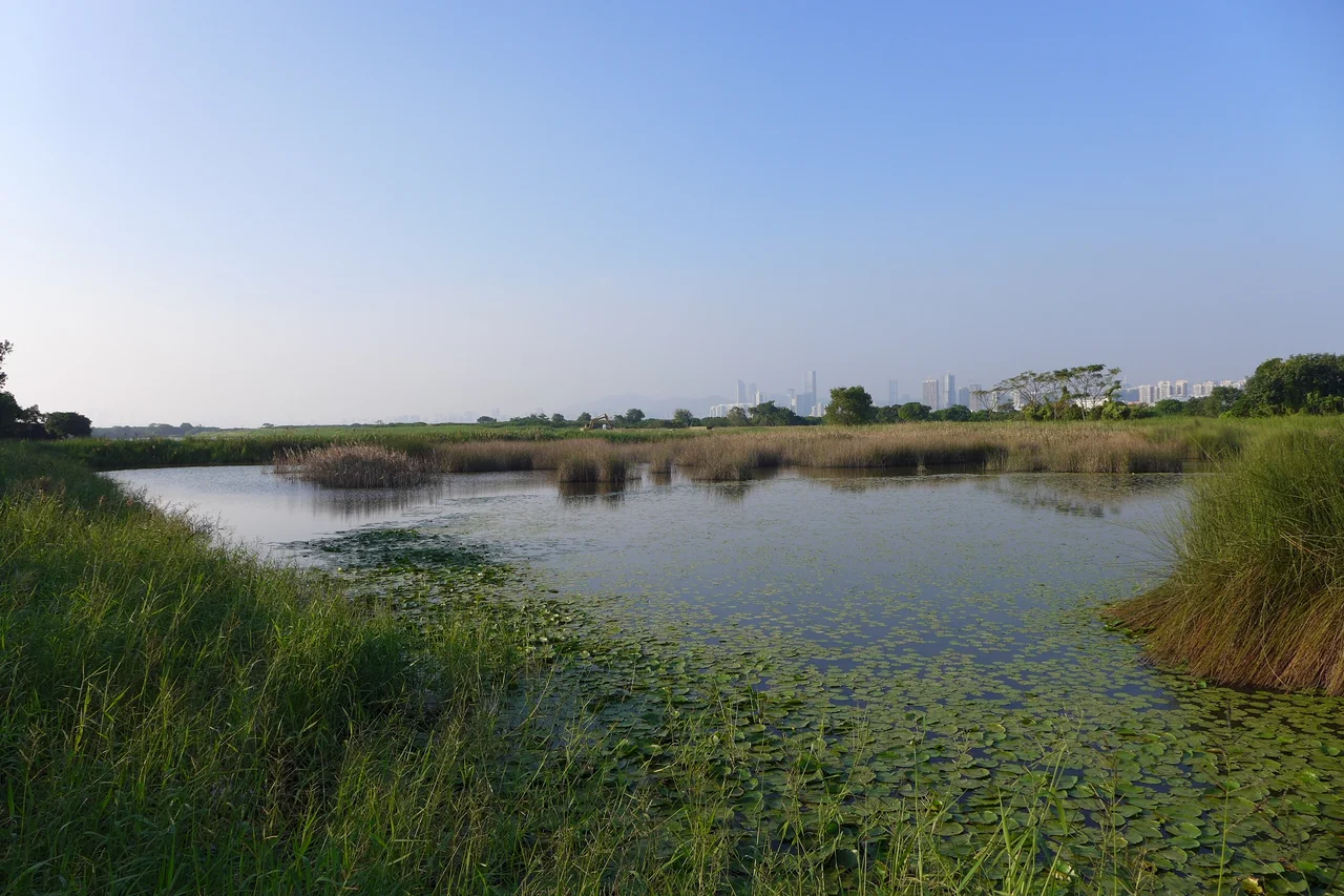
Stand at the edge of a Gei Wai pond at dawn in November and the world you've just left — Hong Kong's towers, Shenzhen's skyline directly across Deep Bay — seems to belong to a different species entirely. The water is shallow and silver. Dozens of Black-faced spoonbills pick their way through the shallows, swinging those distinctive spatula bills in wide arcs. A leopard cat moves somewhere in the reeds. You won't see it — it's nocturnal, and wary — but WWF staff know it's there. Mai Po Marshes is not a refuge from Hong Kong. It is, improbably, a part of it.
Where River Meets Bay
Deep Bay is a shallow estuary on the border between Hong Kong and mainland China, fed by the Sham Chun River, the Shan Pui River, and the Tin Shui Wai Nullah. At its inner reaches, where the mudflats extend and the mangroves take root, lies the 380-acre Mai Po Nature Reserve — and surrounding it, a broader wetland system covering some 1,500 acres. The entire Inner Deep Bay was designated a Ramsar site under the Ramsar Convention in 1995, recognizing it as a wetland of international significance. The designation matters not just symbolically but practically: it obligates the Hong Kong government to manage the site with conservation in mind, even as development presses from both sides of the water. The 24 Gei Wai shrimp ponds — traditional aquaculture enclosures managed according to centuries-old techniques — are maintained deliberately within the reserve. When the sluice gates open at low tide, they drain into tidal channels that become feeding bonanzas for thousands of birds.
The Birds That Come Here
More than 350 bird species have been recorded at Mai Po, arriving in pulses shaped by the East Asian–Australasian Flyway — the great migratory corridor linking Arctic breeding grounds to Australian wintering sites. The numbers are staggering: in recent years, the reserve has hosted over 55,000 migrating birds in a season. A quarter of the world's population of Black-faced spoonbills — one of Asia's most endangered waterbirds — winters here or passes through. Saunders's gull, a small endangered gull with a black hood and a restricted range, is a regular presence. The critically endangered Spoon-billed sandpiper, whose population in the low thousands makes every sighting significant, is recorded here on migration. What makes these numbers sobering is the qualifying phrase that comes with them: overall numbers are declining every year. The pressures are real — rising mudflat levels, Shenzhen's urban expansion across the bay, pollution in the estuary. The birds still come. The question is for how long.
Mammals, Otters, and a Firefly Found Nowhere Else
Birds draw most of the attention, but Mai Po's ecological significance extends well below the canopy. Thirty-eight mammal species inhabit the reserve — more than anywhere else in Hong Kong. Leopard cats are present at one of the territory's highest densities, though their nocturnal habits keep them largely invisible to visitors. Small Asian mongooses are more cooperative, often seen trotting near the Gei Wai ponds on winter days. A small population of Eurasian otters, locally endangered, persists in the reserve's waterways. And in 2011, researchers made a discovery that had nothing to do with vertebrates: the Mai Po bent-winged firefly, Pteroptyx maipo, was identified as a species new to science — the first time the genus Pteroptyx had ever been recorded in mainland China or Hong Kong. An insect found in no other place on Earth, living in a wetland tucked against one of the most urbanized borders on the planet.
Managed and Guarded
The World Wide Fund for Nature Hong Kong has managed Mai Po since 1983. Access is deliberately controlled: visitors need a Mai Po Marshes Entry Permit, obtainable through WWF's guided ecovisit program or by application to the Agriculture, Fisheries and Conservation Department. The reserve receives around 32,000 visitors annually through this system — enough to support the conservation mission through tourism revenue and environmental education, not so many that the birds are disturbed. Even after Mai Po was removed from Hong Kong's Frontier Closed Area in February 2012 — an area sealed since the Cold War era — the nature reserve itself remained restricted, now under the Wild Animals Protection Ordinance rather than security legislation. The restriction changed its legal basis but not its practical effect: Mai Po stays quiet by design. In February 2008, the government closed the reserve for 21 days after a great egret within three kilometers tested positive for H5N1 avian influenza — the fourth such closure in as many years. WWF argued the closure standards were inconsistent and sought HK$1 million in compensation for lost revenue. The tension between public health caution and conservation continuity has no easy resolution when both values are genuinely at stake.
A Sanctuary on a Contested Edge
What makes Mai Po remarkable is not just what it contains but where it sits. Look north from the observation hides and you see Shenzhen — a city of over thirteen million people, its towers a hard line on the horizon. Look south and the towers of Yuen Long and Tin Shui Wai press from the Hong Kong side. This 380-acre marsh exists in the compression zone between two of the world's most intensely developed metropolitan regions. The mudflat levels are rising, possibly from the pressure of upstream development. Pollution enters from multiple directions. And yet the spoonbills still come back each November, the firefly still blinks in the mangroves, and the otters still move through the reed beds at night. Conservation here is not a pastoral fantasy — it is an argument made in real time, in an estuary, against enormous countervailing forces.
From the Air
Mai Po Marshes lies at 22.499°N, 114.046°E in the northwest New Territories, directly south of the Shenzhen border along Deep Bay. From altitude, the marshes are visible as a darker, more irregular patch of green and grey wetland against the rectilinear development of Yuen Long to the east and the bay itself to the north and west. The contrast between the urban grids and the wetland edges is striking at any altitude above 2,000 feet. Nearest airport: VHHH (Hong Kong International Airport) on Lantau Island, approximately 22 km to the south-southwest. At lower altitudes, the Gei Wai pond network — a series of rectangular enclosures — is identifiable from the air, and the mangrove fringe along the bay's edge appears distinctly darker than the surrounding mudflats.
Nearby Stories
- Chapel of St. Francis Xavier 3.5 km away
- Cuiheng 4.1 km away
- 2015 Shenzhen Landslide 16 km away
- Shunde 31 km away
- Wanshan Archipelago 37 km away
- Nanxiong Formation 96 km away
- Heyuan 149 km away
- Checheng Fu'an Temple 629 km away