Maliau Basin
A pilot flying over central Sabah in the 1940s would have seen something extraordinary below: a vast, roughly circular depression in the jungle canopy, ringed by steep escarpments, with no roads leading in and no settlements visible within. Maliau Basin had been there for millions of years, but the modern world did not know what lay inside it. The 588-square-kilometre catchment surrounding the Maliau River was so remote, so walled off by its own geography, that it earned the name Sabah's Lost World. Even today, significant portions of the basin remain unexplored by scientists.
A Fortress of Green
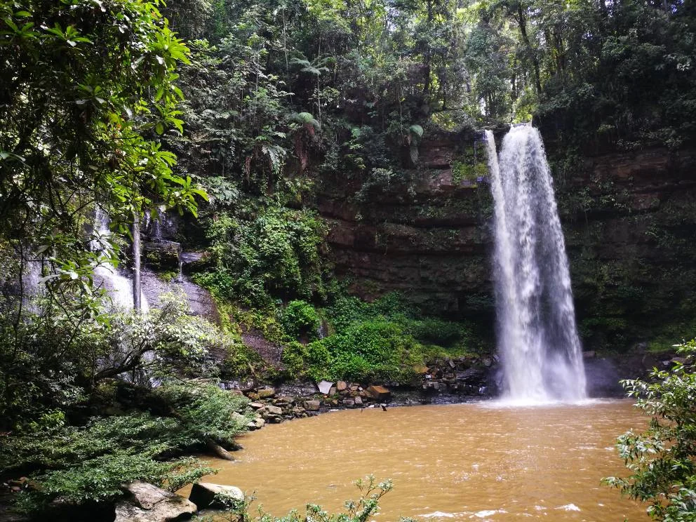
The basin sits near the geographic center of Sabah, in the Tongod District of the Sandakan Division. Its defining feature is the rim: a ring of steep cliffs and ridges that encircle the interior like the walls of a natural fortress, rising to Mount Lotung at 1,667 metres. Within the basin, the Maliau River and its tributaries have carved a landscape of waterfalls, lakes, and deep forest valleys. Maliau Falls cascades through the interior, and Lake Linumunsut sits hidden in the lowlands. The geological isolation created by the rim has allowed ecosystems to develop in near-total seclusion, producing a concentration of biodiversity that rivals anywhere on Earth.
Protection Before Exploration
In an unusual reversal of the typical conservation story, Maliau Basin was protected before it was fully explored. The Sabah Foundation, known as Yayasan Sabah, designated it a conservation area in 1981. Sixteen years later, in 1997, the Sabah State Assembly gazetted the basin as a Protection Forest Reserve under Class I, the highest level of protection. Efforts are now underway to nominate the area as a World Heritage Site, a recognition that would place Maliau alongside sites like the Danum Valley and Kinabalu Park in the global conservation landscape. The decision to protect first and study later may be Maliau's most important legacy.
Scientists in the Lost World
In 2011, the Maliau Basin Studies Centre opened, providing researchers with a permanent base for fieldwork in one of the planet's least-disturbed ecosystems. Universities from across the globe have conducted expeditions here. Sheffield University, Griffith University, and Otago University have all sent field course students into the basin, and the citizen-science organization Taxon Expeditions has brought non-specialist volunteers to participate in species discovery. The basin's birdlife is exceptional, with Maliau being one of only a handful of locations where the elusive Bulwer's pheasant has been photographed. Each expedition adds to the catalog of what lives within the rim, and each catalog entry reinforces the argument for the basin's continued protection.
The World Outside the Walls
Maliau Basin exists in tension with the world beyond its escarpments. Sabah's economy depends heavily on timber and palm oil, industries that have transformed vast tracts of Borneo's lowland forest into plantations. The basin's protected status has kept it intact, but the contrast between the pristine forest within the rim and the altered landscapes outside grows sharper each decade. From the air, the boundary is visible: an abrupt line where unbroken canopy gives way to the geometric patterns of agricultural development. Maliau Basin is not just a wilderness preserve. It is a baseline, a record of what Borneo's forests looked like before the modern economy arrived, and a reminder of what is lost when they are converted.
From the Air
Maliau Basin (4.83°N, 116.90°E) is visible from altitude as a large, roughly circular depression in the forest canopy in central Sabah, ringed by a distinctive escarpment. The basin covers 588 square kilometres and Mount Lotung (1,667 m) marks the highest point on the rim. No airports within the basin; nearest commercial airports are Kota Kinabalu International Airport (WBKK) to the west and Sandakan Airport (WBKS) to the northeast. Best viewed at 10,000-15,000 feet for the full basin profile. The contrast between the pristine forest interior and surrounding developed areas is striking from the air.
Nearby Stories
- Raid on Kalabakan 19 km away
- North Borneo 21 km away
- Danum Valley Conservation Area 29 km away
- Keningau Oath Stone 36 km away
- Keningau Heritage Museum 61 km away
- Agop Batu Tulug Caves 68 km away
- Sebatik Island 110 km away
- The Secret War in Borneo's Jungle 114 km away