
Moidart
Moidart did not get a road until 1966. Until then, you arrived by ferry from Lochailort, or you walked a rough footpath, or you came by sea. Mains electricity took even longer: it was not until 1988 that the residents of Moidart could plug a kettle into a wire connected to the national grid. This is not a footnote about rural infrastructure. It is the central fact of the place. Three things survived in Moidart that the rest of Scotland mostly lost: the Catholic faith, the Gaelic language, and the old Clanranald patterns of life. They survived because no road and no electricity could get in to disrupt them. By 1881 some ninety percent of the population still spoke Gaelic and more than a third spoke no English at all. The isolation that preserved this culture was eventually the isolation that ended it.
The Almost-Island
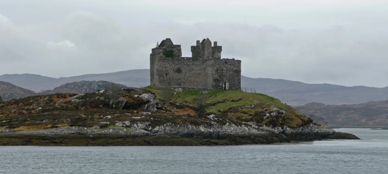
Moidart is part of the area west of Fort William known as the Rough Bounds, and it is nearly an island. Loch Shiel cuts off the eastern edge along a south-southwest to north-northeast line. Loch Moidart blocks the southern edge. Loch Morar and Loch Ailort cut off the north. Only a narrow strip of upland connects Moidart to anywhere else. The peninsula includes the small townships of Dorlin, Kinlochmoidart, and Glenuig. At Dorlin sits Castle Tioram, the ruined fortress of Clann Ruaidhri and the Clanranald branch of Clan Donald, perched on a tidal islet in Loch Moidart that you can walk to at low water. The whole area is part of the Morar, Moidart and Ardnamurchan National Scenic Area, one of forty such areas defined across Scotland to protect exceptional landscapes from inappropriate development.
Mud Mud Loch
The name Moidart is a marvel of accidental redundancy. It comes from the Old Norse mod, meaning mud, and the Norse suffix -art, derived from fjord. So Moidart literally means muddy loch, which is exactly what Loch Moidart is. The name Loch Moidart, in other words, translates as Loch Muddy Loch. The Norse named the loch first. The Gaels later added their own word for loch to a name they no longer understood. The result is a place name that says the same thing twice in two languages. After Viking raids beginning in the 8th century, Moidart became part of the Norwegian-controlled Kingdom of the Isles. In the late 11th century, the Scottish king Malcolm III and Magnus Barelegs agreed the border would run along the coast. Moidart became Scottish.
Castle Tioram and the MacRorys
In the early 12th century the Norse-Gael warlord Somerled took control of the whole region. After his death, his MacRory descendants ruled the lands containing Moidart, known as Garmoran. The 1266 Treaty of Perth turned Garmoran into a Scottish crown dependency. The final MacRory heir, Amy of Garmoran, married John of Islay, Lord of the Isles. He later divorced her in favour of a Stewart princess, but as compensation made their son Ranald the Lord of Garmoran. From Ranald descends the Clanranald branch of Clan Donald, who built Castle Tioram on its tidal islet around this time as the principal seat of the lordship. In 1427, after years of violent internal feuding among Somerled's heirs, King James I summoned the Highland magnates to Inverness, executed Alexander MacGorrie after a show trial, and declared the Lordship of Garmoran forfeit. The actual control of the land continued to shift through marriages, grants, and charters for several centuries.
Jacobites and the Two-Family Battery
Unlike many areas of Jacobite sympathy, no government military road was ever built into Moidart, even after the 1745 Rising. The geography was too difficult and the rebels too thoroughly defeated for the road to seem worth the effort. So Moidart stayed cut off. Catholicism persisted here despite the Scottish Reformation, the persecution that followed, and the strict illegality of the Church in Scotland for centuries afterwards. The Gaelic language stayed dominant into the mid 20th century, before declining sharply: by 2001 fewer than 15 percent of habitual residents spoke it. The same remoteness that protected the old ways also made Moidart useful in the Second World War, when the Special Operations Executive sited several paramilitary training bases here and the Royal Navy established HMS Dorlin at Dorlin for training Beach Signals and Royal Signals sections. The 18th-century Gaelic poet Alasdair mac Mhaighstir Alasdair, tutor of Gaelic to Bonnie Prince Charlie, was raised in Moidart. So was the modern accordion master Fergie MacDonald. The road in changed everything. The Catholic church still stands, the Gaelic place names still echo, but the cultural ecosystem that ran on isolation has dispersed.
From the Air
Moidart sits in the western Rough Bounds of Lochaber at approximately 56.8200 degrees north, 5.6960 degrees west. From the air the peninsula appears as a complex of lochs, ridges, and indented coastline, with Loch Shiel running northeast along the eastern boundary, Loch Moidart cutting in from the south, and Loch Ailort to the north. Recommended viewing altitude 3,000-5,000 feet for the peninsula and surrounding waters. Visual landmarks include Castle Tioram on its tidal islet in Loch Moidart, the A861 road threading along the coast, and Druim Fiaclach mountain in the centre. Nearest airport is Oban (EGEO) about 35 nautical miles south. Glasgow (EGPF) is 90 nautical miles south. Loch Shiel leads northeast to Glenfinnan and the West Highland Line.
Nearby Stories
- Morvern 6.3 km away
- Gavin Maxwell 8.2 km away
- Cairnburgh Castle 9.8 km away
- Neptune's Staircase 11 km away
- Bullough Mausoleum 13 km away
- Bonawe Iron Furnace 18 km away
- Talisker 19 km away
- Glen Affric 23 km away