The Coconut Shell Mountain: Batok and the Tengger's Mistaken Identity
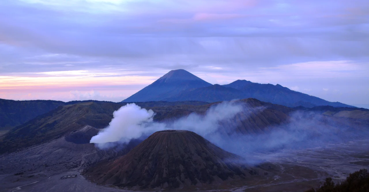
Everyone photographs the wrong volcano. Every sunrise, hundreds of tourists line the northern rim of the Tengger caldera, cameras trained on the perfectly conical peak rising from the Sea of Sand below, and they call it Bromo. It is not Bromo. It is Batok -- the extinct, tree-covered cinder cone that happens to stand directly in front of Bromo's flat, smoking crater. The mix-up is so common that it has become part of the mountain's identity: the volcano that steals the spotlight without trying, the scenic impostor of East Java.
Born from a Coconut Shell
In Javanese, batok means "coconut shell," and the Tenggerese people have a story to explain why. Their mythology tells of Rara Anteng, a princess courted by a powerful giant named Resi Bima. She set him an impossible task to discourage his advances -- digging a vast sea of sand in a single night using only a coconut shell. When he failed, Resi Bima kicked the shell away in rage, and where it landed, a mountain rose. That mountain became Batok. The legend connects to the broader Tengger creation story of Rara Anteng and Joko Seger, whose names combine to form "Tengger" and who are considered the ancestors of the Tenggerese people. The Sea of Sand that Resi Bima tried to dig? It exists too -- a 5,250-hectare expanse of volcanic ash sprawling across the caldera floor at 2,100 meters elevation, the only sand sea inside a conservation area in Indonesia.
The Quiet One in a Crowded Caldera
The Tengger caldera is enormous -- roughly 10 kilometers across, formed by an ancient eruption more than 45,000 years ago. From its floor, four volcanic cones have emerged over the millennia. Bromo is the famous one, still active, still belching sulfurous smoke, still demanding offerings during the annual Kasada ceremony when Tenggerese Hindus throw livestock and crops into its crater. Semeru, visible in the distance at 3,676 meters, is the highest peak on Java and erupts with alarming regularity. But Batok is the quiet one. At 2,440 meters, it stands slightly taller than Bromo and considerably more photogenic -- a near-perfect cone rising from the ashen plain, its slopes dense with casuarina trees. It is the only peak in the caldera that is no longer active, its volcanic fire long extinguished, its crater now forested rather than fuming.
The View That Deceives
The confusion between Batok and Bromo is not a matter of carelessness. It is a matter of geometry. From the popular viewpoints along the caldera's northern rim -- particularly the sunrise lookout at Penanjakan -- Batok sits squarely in the foreground, its symmetrical cone dominating the composition. Bromo crouches behind it, lower and flatter, its crater visible only as a jagged line of rock trailing a wisp of white smoke. The eye goes to the tallest, most dramatic shape, and that shape is Batok. Postcards, Instagram feeds, and travel brochures perpetuate the error. The irony runs deeper than mistaken identity. Bromo draws the crowds, the ceremonies, the offerings, and the fear that comes with an active volcano. Batok draws the photographs. One mountain commands reverence; the other commands the frame. Neither seems to mind the arrangement.
A Park of Fire and Ceremony
Bromo Tengger Semeru National Park, declared in 1982, spans over 50,000 hectares across four regencies: Probolinggo, Pasuruan, Malang, and Lumajang. Within its boundaries live the Tenggerese, one of the few Hindu communities on majority-Muslim Java, descendants of people who trace their lineage to the Majapahit Empire. Their annual Kasada ceremony -- born from the legend of Joko Seger and Rara Anteng's sacrifice of their youngest child, Kusuma, to the volcanic gods -- takes place on the 14th day of the Kasada month, under a full moon. Worshippers trek across the Sea of Sand to Bromo's rim and cast offerings into the smoking crater. Batok watches silently from its perch, the mountain that mythology made from a discarded tool. Its forests grow thicker each year, undisturbed by the eruptions and rituals that animate its neighbors. In a landscape defined by fire, Batok is the one that chose peace.
From the Air
Mount Batok sits at approximately 7.93S, 112.95E within the Tengger caldera at 2,440 meters (8,005 ft) elevation. The caldera is roughly 10 km in diameter and visually striking from altitude -- a vast sand-colored basin with multiple volcanic cones rising from its floor. Batok is the tree-covered cone; Bromo is the smoking one immediately to its east. Mount Semeru (3,676 m) dominates the skyline to the south. Nearest major airport is Juanda International Airport (WARR/SUB) in Surabaya, approximately 100 km to the northwest. Abdul Rachman Saleh Airport (WARA/MLG) in Malang is closer at roughly 50 km west. Terrain requires caution -- volcanic peaks, caldera walls, and unpredictable thermals. Morning visibility is often excellent; afternoon convective clouds are common.
Nearby Stories
- Kelud: The Mountain That Swallows Its Own Lake 23 km away
- Where an Empire's Memory Lives in Clay and Stone 23 km away
- Bangil Railway Station 31 km away
- Meru Betiri: The Last Forest on Java's Southern Edge 35 km away
- Shaken Foundations: The 2021 East Java Earthquake 65 km away
- Blue Fire and Bitter Water: Ijen Volcano 76 km away
- Where Three Worlds Meet: The Great Mosque of Sumenep 88 km away
- The Ghost Boat That Built an Empire 400 km away