Paraiba do Sul
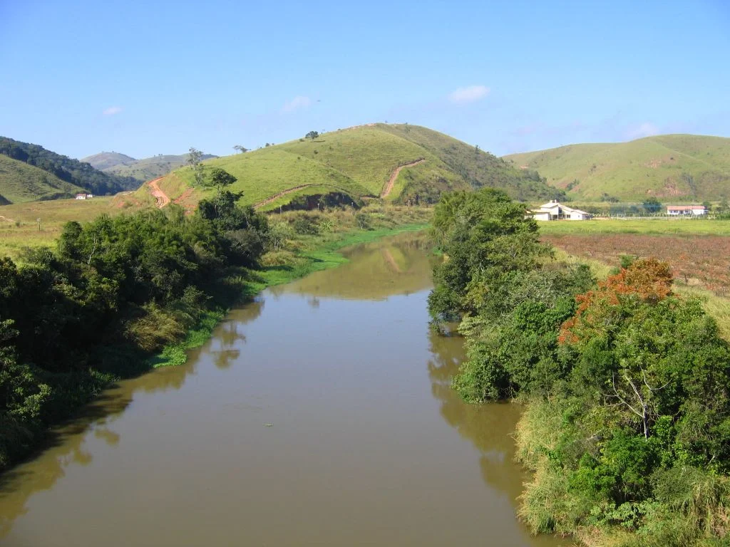
The river does not give up its name until it meets another. Above the Paraibuna dam, in the interior of Sao Paulo state, it is called the Paraitinga. Only when the Paraitinga joins the Paraibuna does the combined flow become the Paraiba do Sul - the South Paraiba, to distinguish it from the other Paraiba River that runs through northeastern Brazil. From that moment on it is one river, 1,137 kilometers long, bending west to northeast across three states before emptying into the Atlantic near Campos dos Goytacazes. Along its course stand some of the most heavily industrialized cities in southeast Brazil. Embraer builds aircraft on its banks. Volkswagen and Ford make cars. Brazil's first steel plant was built on its water. The Baron of Maua's engineers laid train tracks beside it. And beneath all that, pushing past smokestacks and concrete, the river holds roughly 100 native fish species, 40 percent of them found nowhere else on Earth. It is at once the heart of industrial Brazil and a biological refuge trying to survive the industry it feeds.
Course and Valley
The river rises in the high country of Sao Paulo state and flows through a long broad valley whose fertility was recognized early. The Paraiba Valley - the Vale do Paraiba - has been one of the most densely populated parts of Brazil for centuries. It runs between latitudes 20 degrees 26 minutes and 23 degrees 39 minutes south, and covers about 57,000 square kilometers across three states. Its main tributaries are the Jaguari, Buquira, Paraibuna, Preto, Pomba, and Muriae. The Pomba and Muriae are the longest, joining the main river 140 km and 50 km from the mouth. Cities cluster along the banks like beads on a thread. In Rio de Janeiro state: Barra do Pirai, Barra Mansa, Tres Rios, Paraiba do Sul, Sapucaia, Campos dos Goytacazes - center of a rich sugar-cane region - Vassouras with its respected agricultural university, and Volta Redonda, site of Brazil's first steel industry. In Sao Paulo: Aparecida, Brazil's most famous Marian pilgrimage site; Guaratinguetá; Sao Jose dos Campos, home to Embraer; and Taubate with its Volkswagen and Ford plants. In Minas Gerais: Alem Paraiba, Estrela Dalva, and Juiz de Fora, an important manufacturing city on the Paraibuna tributary.
Navigating What Little Can Be Navigated
A river this long should be a highway. The Paraiba do Sul is not. Only two segments can be navigated at present. The lower 90 kilometers between the mouth and Sao Fidelis see incipient navigation by small boats carrying mainly construction material toward Campos dos Goytacazes. The upper middle section, about 280 kilometers between Cachoeira Paulista and Guararema, allows tourist boats. Elsewhere navigation is blocked by waterfalls, rapids, sections of steep declivity, and hydroelectric dams built without locks. Highway and railway bridges cross the water in dozens of places. Roads and rail lines press against both banks. Cities stand where any dock would go. The river supports industry and life along its shores, but it does not support a viable inland shipping route. That absence shaped the region's transportation infrastructure - when the river could not move freight, somebody had to build a rail line, and then a highway, and then another highway.
Fish and What Pressures Them
Water temperatures in this river follow a southern Brazilian pattern of distinct seasonal variation rather than the relatively stable profile of rivers further north. In Lorena, Sao Paulo, one survey recorded water as warm as 26.6 degrees Celsius in summer and as cool as 15.2 degrees in winter. The pH is neutral, generally between 6 and 8 - favorable conditions for a diverse fish fauna. Just over 100 native fish species live in the Paraiba do Sul basin, belonging mostly to the Loricariidae, Characidae, and Trichomycteridae families. About 40 percent of those species are endemic to the basin - they exist nowhere else. The entire genus Oligobrycon is restricted to these waters. But density and industry put constant pressure on the system. Studies of the native cichlid Geophagus brasiliensis have found heavy metal levels that exceed Brazilian food safety limits. Forty-six non-native fish species now compete for habitat. Parasitic copepods like Lernaea cyprinacea have arrived on hitched rides. Brycon insignis and Pogonopoma parahybae are seriously threatened. The catfish Potamarius grandoculis, known only from the mouth of the Paraiba do Sul and the Doce River, may already be extinct.
The Conservation Plan and What Remains at Risk
Other threatened species add weight to the river's precarious status. The bivalves Diplodon dunkerianus, D. expansus, and D. fontaineanus struggle with reduced water quality and sediment changes. Hoge's side-necked turtle, Mesoclemmys hogei, is one of the most endangered turtles in South America. The Brazilian government published a national conservation plan with recommendations for the river basin in 2010, acknowledging what biologists had been saying for years: the Paraiba do Sul is a river that carries both extraordinary biological value and extraordinary anthropogenic pressure, and the two cannot continue their current balance indefinitely. To fly over the Paraiba do Sul is to see the problem in landscape form - a river threading through sprawling urban and industrial zones, factories backing up to its banks, highways shadowing it the entire length. To understand what the water contains is to see that despite everything, something of the pre-colonial ecology still survives in its pools and riffles, and the question is whether it will survive another century of the Brazil it helped build.
From the Air
The Paraiba do Sul River flows 1,137 kilometers from its source near 23 degrees south in Sao Paulo state to its mouth at about 21.6 degrees south, 41.0 degrees west near Campos dos Goytacazes, where the highlighted coordinates point. Useful navigation reference along the populous Vale do Paraiba corridor between Rio de Janeiro and Sao Paulo. Nearest airports along the course: Galeao (SBGL) Rio de Janeiro, Guarulhos (SBGR) Sao Paulo, Campos (SBCP) at the mouth. Cruise altitudes of 6,000 to 10,000 feet in clear weather give excellent views of the winding river, its valley cities, and the industrial corridors that line its banks.
Nearby Stories
- Itaboraí Formation 36 km away
- Desengano State Park 57 km away
- Guarapari 82 km away
- Muriaé 93 km away
- Petrobras 36 95 km away
- Vila Velha 105 km away
- Macaé 107 km away
- Prainha Historic Site 135 km away