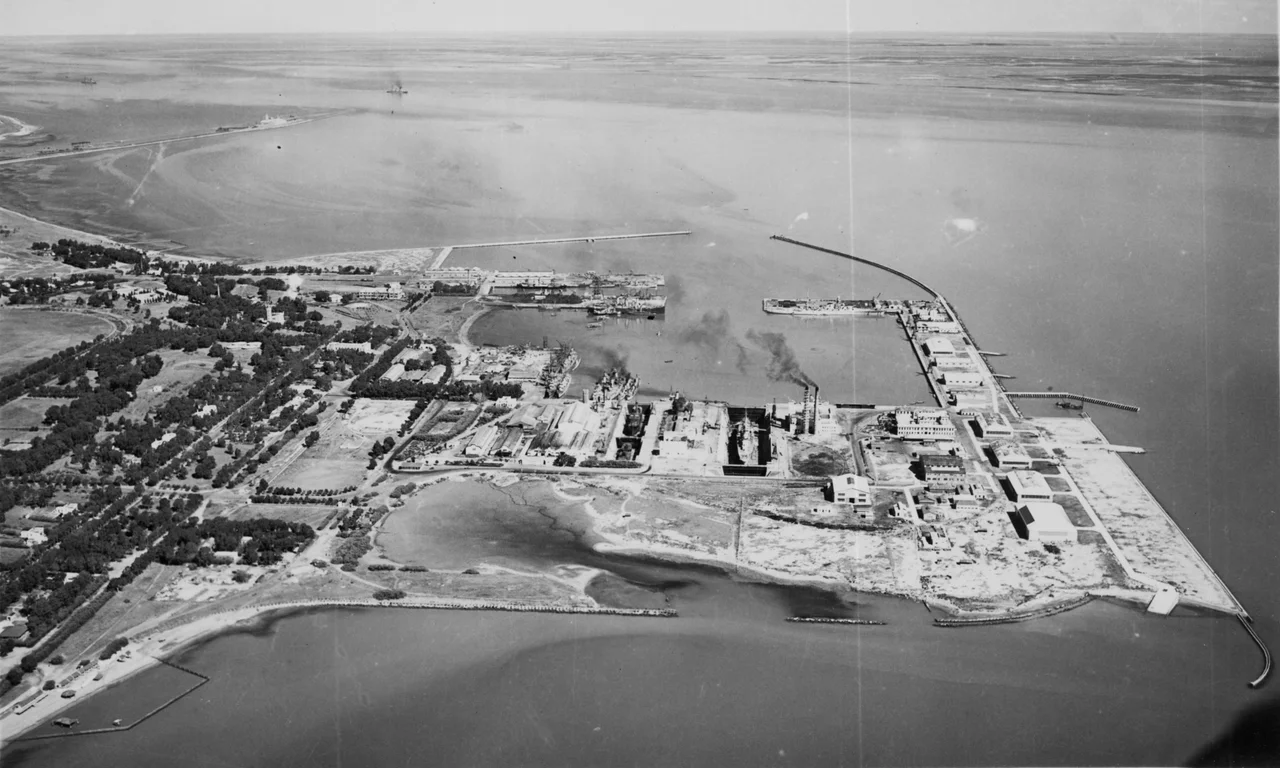

Port Belgrano Naval Base
Forty kilometers from a monument shaped like a wave, the Argentine fleet has ridden at anchor for more than a century. Port Belgrano, beside the town of Punta Alta near Bahía Blanca, is the largest naval base in the country, the home of the Sea Fleet, and the place where Argentina concentrates its major warships and arsenals. It takes its name from a small sailing ship, the brigantine General Belgrano, that charted these waters in 1824, which in turn honored Manuel Belgrano, a founding father of the nation. The base is not just a harbor. It is a small city of the navy, and increasingly, a launching ground aimed at space.
Finding the Deep Water
The base exists because someone went looking for the right water. A ship's captain, Félix Dufourq, carried out the studies that identified this sheltered, naturally deep stretch of coast as the ideal place to build. The Italian engineer Luis Luiggi designed the works, and on 30 November 1896 the facility opened under the name Puerto Militar, the Military Port. It was a project born partly in secrecy, set in motion by a decree of President José Evaristo Uriburu. In 1911 a French-owned railway, the Ferrocarril Rosario y Puerto Belgrano, laid a broad-gauge line connecting the base to the inland city of Rosario. The harbor took its present name in 1923. Stone by stone, quay by quay, a frontier anchorage became the spine of a navy.
A Century of Fleets
As the Argentine navy grew, so did Port Belgrano. Through both World Wars, the fleet's heavy ships were docked here. During the Cold War, the base sheltered aircraft carriers. The shipyard has never stopped working, maintaining and refitting vessels and submarines decade after decade. Today the base anchors destroyers like the ARA Almirante Brown and ARA La Argentina, a squadron of Espora-class corvettes, amphibious and supply ships, a fleet of tugs, and the Antarctic icebreaker ARA Almirante Irízar. It does not stand alone. Close by lie the related arms of Argentine naval power: the Marines' camp, called Baterías, and the naval aviation air base at Comandante Espora. Alongside the quays stand a naval hospital, six military schools at the middle and tertiary level, a printing press that produces the magazine Gaceta Marinera, the Stella Maris parish church, a museum, and seven residential neighborhoods for the families of those who serve. It is a working community as much as a strategic asset, organized entirely around the sea.
The Ship That Did Not Come Home
One name echoes here above the others. The cruiser ARA General Belgrano made Port Belgrano her home for some thirty years. On 2 May 1982, during the Falklands War, a British submarine torpedoed her, and she went down with 323 of her crew. It was a defining tragedy of that conflict. Today a monument stands at the base, in front of the Sea Fleet Command, beside the very anchorage the cruiser used for three decades, honoring the ship and her 323 lost sailors. The war's shadow lingered in other ways. When a British Royal Navy patrol ship limped into Port Belgrano in April 2006 for repairs, it was the first time since 1982 that a British warship had entered the Argentine base.
Aiming for Orbit
The base's newest mission points straight up. On land ceded to Argentina's space agency, CONAE, engineers are building the Centro Espacial Manuel Belgrano, intended as the launch site for the country's home-grown Tronador family of rockets. The location was chosen for reasons the navy understood long ago: existing facilities, security already in place, ample open ground, and a coastal position well suited for launches into polar orbit. The goal is ambitious. Argentina aims to loft its first satellites aboard the orbital Tronador II from here, with the larger version targeted to fly around 2030, after a series of suborbital test vehicles proves the technology. The harbor that found the deep water in 1896 now reaches for the sky.
From the Air
Port Belgrano Naval Base sits at approximately 38.89 degrees south, 62.10 degrees west, beside Punta Alta and the town of Coronel Rosales, on the southeastern shore of the Bahía Blanca estuary. From the air, look for the extensive harbor works, moored gray warships, and dredged channels cutting through the pale tidal flats, with the adjacent Comandante Espora Naval Air Base (also the civil Comandante Espora Airport, SAZB / BHI) just to the northwest. The city of Bahía Blanca lies about 29 km to the northwest. National Route 3 passes nearby. This is active military airspace shared with naval aviation, so the field is the dominant landmark. Santa Rosa (SAZR) lies far to the northwest and Neuquén (SAZN) to the west. Coastal fog and humidity off the bay can reduce visibility; otherwise the flat terrain offers clear sightlines.
Nearby Stories
- Monte Hermoso 20 km away
- Desert Campaign (1833–1834) 43 km away
- Sierra de la Ventana (mountains) 58 km away
- Tres Arroyos 115 km away
- The Works of Francisco Salamone 167 km away
- Carmen de Patagones 179 km away
- Villa Epecuén 202 km away
- Disappearance of ARA San Juan 845 km away