
Ren'ai Township
On the morning of October 27, 1930, a school sports day in the mountain village of Wushe turned into the most dramatic act of resistance in Taiwan's colonial history. Seediq warriors, led by headman Mona Rudao, rose against decades of forced labor, cultural suppression, and the slow erasure of everything their communities held sacred. What happened there — and what the Japanese colonial government did in response — defines Ren'ai Township's place in Taiwan's memory to this day. Long before that morning, and long after, Ren'ai has been and remains the homeland of three distinct indigenous peoples: the Seediq, the Atayal, and the Bunun, each with their own languages, traditions, and histories stretching back far beyond any colonial border.
The Land That Shaped Its People
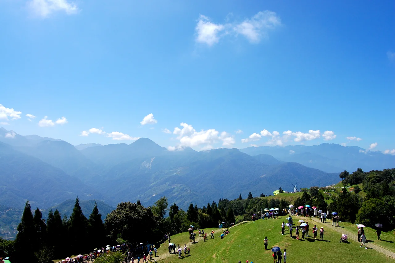
Ren'ai Township covers 1,300 square kilometers of some of Taiwan's most rugged terrain — the second-largest township in Nantou County by area, yet home to only about 15,000 people. That low density is not emptiness. It is mountains: steep, forested ridgelines that rise into cloud, river gorges cutting through the Central Mountain Range, and high-altitude meadows where the air is thin and the light changes hour by hour. The township's main artery, Provincial Highway 14, climbs from the flatlands of Puli into this world, connecting Ren'ai to the coast and to Hualien via Highway 14A across the range. Traveling the mountain road, the landscape insists on your attention. This is not a place that lets you pass through it casually.
Three Peoples, One Township
Ren'ai's indigenous communities are not a single bloc but three nations living across different valleys and elevations, each with distinct cultural identities. The Atayal are Taiwan's second-largest indigenous group and have long inhabited the northern and western ridges of the Central Mountains. The Seediq — recognized as a separate people from the Atayal in 2008, after decades of administrative grouping — live primarily in the Wushe area, carrying traditions of weaving, headhunting ritual, and the gaga ethical code that governed community life. The Bunun occupy the higher southern reaches, known for their polyphonic vocal music and deep relationship with the deer-hunting calendar. Today all three communities maintain active cultural programs, languages under revitalization, and a visible presence in the villages of Ren'ai.
October 27, 1930: The Wushe Incident
Mona Rudao, chief of the Mahebu village, had watched for years as Japanese colonial administration eroded Seediq life: forced road-labor, prohibitions on traditional tattooing and head-hunting ceremonies, humiliating treatment by police officers, and the grinding pressure to abandon the gaga. After a flash point in early October 1930 — a Japanese official rebuffed a toast offered at a wedding — Mona Rudao united six Seediq villages in a carefully planned uprising. On the morning of October 27, some 300 warriors attacked the Wushe public school during an athletic meet, killing 134 Japanese civilians and police. The Japanese colonial response was overwhelming and methodical: army units, air bombardment, and — in what historians have documented as likely the first use of chemical weapons in Asia — gas bombs dropped on Seediq positions in the forests. Of the approximately 1,200 Seediq directly involved in the uprising, 644 died. Around 290 chose to end their own lives rather than surrender. Mona Rudao died on November 28, 1930, in the mountains above Wushe. He was found years later, his body preserved by the forest conditions, and has since been returned to his homeland with the dignity his life deserved.
After the Incident: Memory and Recognition
The Wushe Incident did not end with Mona Rudao's death. The following year brought what is sometimes called the Second Wushe Incident, in which the Japanese colonial government tacitly permitted rival indigenous groups to attack the surviving Seediq who had surrendered. The remaining Seediq of the six uprising villages — reduced from more than 1,200 to around 500 — were relocated to a lowland settlement and further marginalized. For decades under both Japanese and later Kuomintang rule, the Wushe Incident was a complicated and often suppressed chapter. Mona Rudao was variously cast as a bandit, a hero, or a tragic figure depending on the political moment. Today a memorial park in Wushe village, a museum, and the remains of the old school ground bear witness to what occurred. The 2011 animated film Warriors of the Rainbow: Seediq Bale brought the story to international audiences. The Seediq people's own telling of their history — on their own terms — continues.
Mountains, Farms, and the Road Through
For visitors today, Ren'ai is most accessible through Qingjing Farm, a high-altitude agricultural area established in the 1960s by veterans of the Republic of China military who were resettled here after the civil war. The farm sits above 1,700 meters and is known for its open grasslands, sheep, and views across the Central Mountains. In cooler months, mornings bring a sea of cloud below the ridgelines. Cycling the mountain roads demands fitness and respect for the terrain — checking your tires before setting off is earnest advice, not a formality. The road to Taroko National Park via Highway 14A is one of Taiwan's more dramatic mountain crossings, threading between cliffs and river valleys on the way to the east coast. Ren'ai asks more of travelers than flatter places do. Most find it worth the effort.
From the Air
Ren'ai Township lies at approximately 23.92°N, 120.68°E in the Central Mountain Range of Nantou County, Taiwan. Approaching from the west, the terrain rises sharply from the Taichung basin into steep ridgelines reaching 2,000–3,000 meters. The township is best surveyed at 8,000–12,000 feet, where the river valleys and Highway 14 switchbacks are visible carving through the forested range. Qingjing Farm's high meadows show as a lighter patch against dark forest on the western slopes. The nearest major airport is RCMQ (Taichung International), approximately 55 km to the northwest. Wushe village sits near the geographic center of the township. Visibility is frequently limited by cloud cover at ridge level; clearest conditions tend to be after frontal passage in autumn and winter.
Nearby Stories
- Shigang Dam 2.7 km away
- Taixi, Yunlin 4.9 km away
- Xitou Nature Education Area 7.2 km away
- Lintianshan Forestry Culture Park 11 km away
- Taroko National Park 20 km away
- Smangus 36 km away
- China Airlines Flight 611 56 km away
- Taiwan Strait 69 km away