Sabu-Jaddi
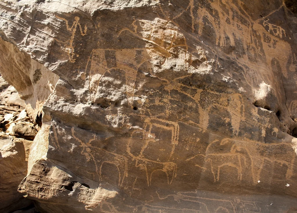
On a sandstone cliff above the Nile, 600 kilometers north of Khartoum, an unknown Nubian artist pecked the outline of a hippopotamus. Another carved a giraffe being chased by dogs. Another drew elephants, both ears showing, deeply gouged into rock that had baked in the sun for a very long time. None of these animals live here anymore. The climate that fed them is gone. But the drawings - more than 1,600 of them, covering the cliffs between the villages of Sabu and Jaddi - remain as a kind of bulletin board posted by six thousand years of Nubians, each generation adding its own creatures, its own boats, its own symbols that nobody today can quite read.
A Gallery Above the Third Cataract
Sabu-Jaddi sits at the downstream end of the Third Cataract region, on the east bank of the Nile. The rock drawings spread across rugged sandstone cliffs along a bend of the river and continue into the narrow wadi Jaddi that cuts inland. The oldest drawings date from the early Holocene, when the Sahara was savannah and the hippos and crocodiles and lions and leopards depicted here were not exotic - they were just what you saw while you herded your cattle. Later artists added camels, a reliable marker that the climate had dried and the old ways had changed. The cattle are drawn in a distinctive, almost geometric style, often with corbels distorted for reasons that might have been artistic, might have been symbolic, might have been marking of specific herds. Human figures appear more rarely - smaller, less emphasized than the animals they lived among.
The Boats
On flat sandstone slabs along the right bank of the wadi, somebody carved boats. Dozens of them, in groups, each one steered with oars. Two types emerge from the crowd: curved-bottom boats, and flat-bottomed boats with upright stern and bow. On some, a small figure stands on the roof of the ship's cabin - a pilot, steering with his weight. These are Nile boats, not abstract symbols. They show how people moved through this landscape, how grain and cattle and salt and rumors traveled up and down the valley. The boat carvings are reminders that the Nile has always been the highway, and that even pastoralists driving cattle through a green Sahara understood river craft - because everything they could not grow or hunt, they traded for on the water.
A Site Under Pressure
Sabu-Jaddi was added to the World Monuments Watch List in 2016 because of plans for the Kajbar Power Station, a proposed hydroelectric dam on the Nile that would flood parts of the site. The dam has been controversial for years - local Nubian communities have resisted it hard, concerned both about the loss of villages and the drowning of heritage like this. The rock drawings are not moveable the way a temple or a statue can be relocated. They are the cliff. If the water rises, they go under. For now, the site remains, weathered by sun and sand and the occasional winter rain, visited mostly by archaeologists and the people who live nearby - who have always known the drawings were there, long before outside scholars came to count them.
Six Thousand Years of Hands
The most moving thing about Sabu-Jaddi is how long it kept being used. Early Holocene artists drew the wild animals of the Green Sahara. Later, as the climate dried, new artists added cattle. Later still, camels. Some of the symbols might be tribal marks. Some might be camel brands. Some are just lines and dots that clearly meant something to the person who pecked them but mean nothing to us. Neville Chittick first documented the engravings scientifically in 1962. David N. Edwards, writing in 2006, called rock drawings "the most enduring monuments of Middle Nubia." Six thousand years of people marking the same cliff with the same kind of patient, stone-on-stone work. The giraffes are still running. The hippos are still coming up for air. Everyone who drew them is long gone, but the cliffs have not forgotten.
From the Air
Located at 19.93N, 30.54E on the east bank of the Nile in Sudan's Northern State, roughly 600 km north of Khartoum and near the downstream end of the Third Cataract. Recommended viewing altitude: 2,000-4,000 feet AGL along the Nile bend between the villages of Sabu and Jaddi to see the sandstone cliffs where the drawings are concentrated. The carvings are not visible from altitude, but the distinctive curve of the river and the rugged terrain on the east bank are. Nearest major airport is Dongola (HSSW), about 80 km to the south. Expect clear desert air and an abrupt line where cultivated greenery on the Nile gives way to bare sandstone cliff.
Nearby Stories
- Kerma 9.6 km away
- Soleb 26 km away
- Nubia 110 km away
- Selima Oasis 141 km away
- Semna (Nubia) 143 km away
- Uronarti 175 km away
- Northern State (Sudan) 235 km away
- Lake Ptolemy 410 km away