Sandwater
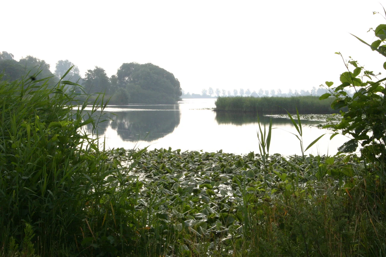
Sandwater is doing something most lakes never do twice: vanishing. Five thousand years ago, during the warm Atlantic period that opened up northern Europe to broadleaf forests, water gathered here on the edge of the geest near what is now Simonswolde. Then the climate shifted, the land rose, and the lake quietly dried out. Two thousand years ago, conditions changed again, and Sandwater reappeared in roughly the same place. Now, slowly, the reeds are coming in. Open water that once covered a much larger area has shrunk to about 0.22 square kilometers. Lily pads thicken the surface. Mud accumulates underneath. Stand on the edge of one of East Frisia's few surviving natural inland seas and you are watching a long, slow third disappearance unfold in real time.
The Edge of the Geest
Geographers have a word for the East Frisian threshold: geest, the sandy uplands that the ice sheets left behind after the last glaciation. South of Aurich, in the municipality of Ihlow, this slightly higher ground bumps up against soft fen country, and Sandwater pools in the seam between the two. Fen lakes form where groundwater meets a shallow basin and refuses to drain. They are flat, broad, never deep — wading birds know them best. The name itself was once a description rather than a label. Old residents called it Sandwater because the water was so clear over sandy bottom that you could see your boots, a quality that depends on a particular underwater ecology now mostly gone.
The Lake That Cleaned Itself
For most of its existence Sandwater filtered itself. Beds of pondweed, floating water-plantain (Luronium natans), and lesser water-plantain (Baldellia ranunculoides) covered the lake floor, drinking up dissolved nutrients and producing the relatively clean, mineral-rich water the name remembered. That equilibrium ended at the beginning of the 1960s, when engineers dyked the lake and drained the surrounding fields for agriculture. The hydrology shifted. The nutrient balance changed. Eutrophication crept in. The picky old underwater flora retreated, and a new cast moved in: frogbit, water violet, flowering rush, arrowhead. Pretty plants, all of them. But pretty plants tell a different story now — one of enrichment, accumulation, and the slow conversion of open water into wet meadow.
Reeds Winning by Inches
Since 1973 the lake and 59 hectares of surrounding wetland have been protected as a nature reserve, less to preserve the lake than to preserve what the lake supports. The expanding reed beds are the headline ecological feature now. Common reed (Phragmites australis) makes superb nesting cover for marsh warblers, reed buntings, and other reed-bed specialists, and the borders of Sandwater have become important breeding and feeding grounds for waterfowl. The same reeds, though, are also the reason the open water keeps shrinking. Reeds trap sediment, drop biomass, build up muck, and march outward from the shore each season. Large carpets of white and yellow water lilies — Nymphaea alba and Nuphar lutea — accelerate the silting from above. Conservation here is mostly about deciding which version of Sandwater to keep, because doing nothing means the lake eventually closes itself.
An Inland Sea in Miniature
What makes Sandwater worth defending is partly what it is and partly what it represents. East Frisia is a land made of water — North Sea coast, Wadden tidal flats, river estuaries, drainage canals, fens and bogs everywhere — and yet the natural standing water of the inland fen lakes has nearly all been drained, diked, deepened, or built over. The few survivors are small, easy to miss, and easy to lose. Walking the trails around Sandwater on a still summer morning, with reed warblers chattering in the curtain and a pair of mute swans tracing the shoreline, you are seeing a landscape that nearly disappeared from the region twice already, and which is in the slow process of disappearing a third time on its own schedule. The view is quietly extraordinary precisely because it is so plausible to lose.
From the Air
Sandwater is centered near 53.368 N, 7.417 E, in the municipality of Ihlow about 8 km south of Aurich and 18 km east of Emden. From altitude it appears as a small, dark, irregularly oval lake fringed with pale reed beds, set in the seam between flat polders to the west and the slightly higher Aurich geest to the east. The 59-hectare protected area shows up as a green wedge in otherwise cultivated country. Nearest airports: Emden (EDWE) about 18 km west, Leer-Papenburg (EDWF) about 30 km south, Wilhelmshaven (EDWI) about 50 km east-northeast. Bremen (EDDW) is about 100 km southeast. Spring and early summer mornings give the best visual contrast; autumn ground fog can submerge the whole basin.
Nearby Stories
- Wilhelmshaven LNG Terminal 3.5 km away
- Veenkoloniën 6.1 km away
- Varel 6.2 km away
- Juist 7.6 km away
- Delfzijl 7.8 km away
- Dornumersiel 9 km away
- Papenburg 11 km away
- Hatten 19 km away