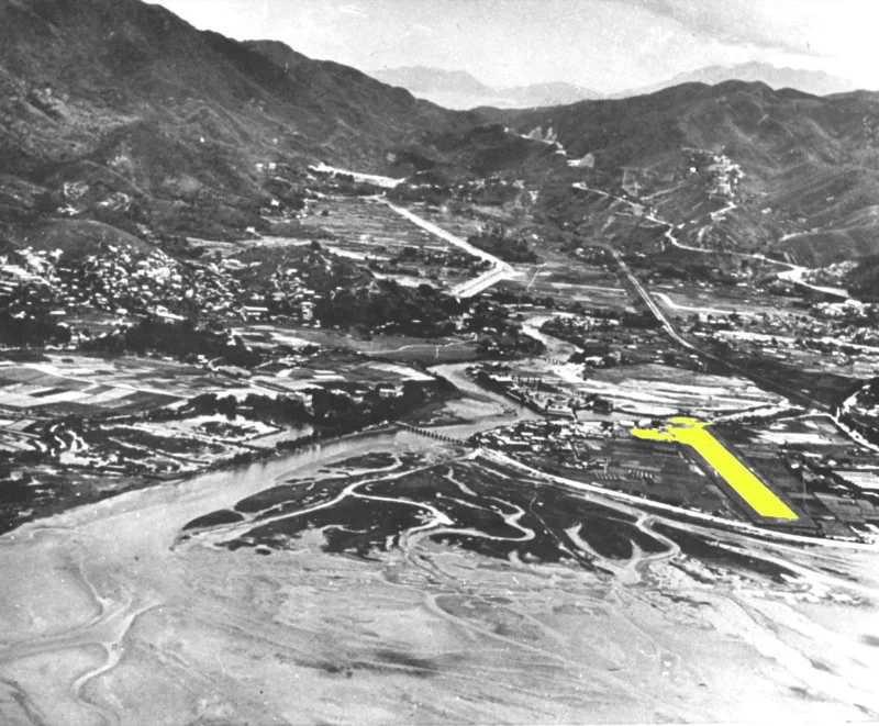

Sha Tin Airfield
On 18 March 1911, a Belgian pilot named Charles van den Born climbed into his Farman Mk II biplane — a fragile canvas and wire construction he called Wanda — and lifted off from a field near Sha Tin. It was the first powered flight in Hong Kong's history. The crowd that watched him had no way of knowing that the same shallow valley, with its tidal flats and paddy smell, would one day become a full military airfield, then be obliterated by a typhoon, then be demolished and buried under a shopping mall, a heritage museum, and a park. Hong Kong's air history began here, and here, within half a century, it also vanished.
A Belgian Over Tide Cove
Charles van den Born's 1911 flight established Sha Tin's place in aviation history, but the moment was not followed immediately by any permanent infrastructure. The Farman biplane rose and returned, the crowd dispersed, and the area went back to rice paddies and fishing. It was not until 1949, thirty-eight years later, that an actual airfield was constructed on what was then still open land along the Shing Mun River, looking out over Tide Cove. The Royal Air Force built it — RAF Shatin, formally — though the RAF's tenure was brief. Military aviation in Hong Kong was primarily an army concern, and the airfield was soon transferred to the British Army's Army Air Corps.
The Observation Post Flights
Sha Tin Airfield functioned not as a combat base but as an air observation post station — a specific and demanding role. Air observation post flights were small units that used light aircraft to scout terrain, direct artillery, and provide aerial reconnaissance. Through the 1950s and into 1960, the Army Air Corps rotated multiple flights through Sha Tin: No. 1903 Flight arrived in April 1949 and left in 1951; No. 1900 Flight served from April 1953 to September 1957; No. 7, 8, 12, 16, 25, and 29 Flights all passed through in turn. All operated under the command of the 40th Infantry Division. The aircraft was the Auster AOP.6, a small high-wing monoplane also used by the Royal Hong Kong Auxiliary Air Force. The airfield's runway was a single concrete strip, 600 metres long, oriented 05/23. Facilities were modest: a control tower, corrugated steel hangars, the usual temporary architecture of a minor military station. The headquarters building was the Ho Tung Lau mansion, a more substantial structure on the Tide Cove edge of the site.
Typhoon Wanda's End
Typhoon Wanda struck in 1962 with a storm surge that overwhelmed the low-lying airfield. The flooding was severe enough to end operations. What Wanda damaged, the RAF chose not to rebuild; Sha Tin's aviation role was transferred to Kai Tak around 1963, and the airfield passed into disuse. The Royal Air Force had already been consolidating its Hong Kong operations at RAF Shek Kong, and a flooded strip on the Shing Mun River floodplain did not fit into that strategy. The Army Air Corps club, which had remained at the airfield until 1970, eventually moved on as well. Sha Tin Airfield spent its last years as an abandoned concrete strip, slowly being reclaimed by the city growing around it.
Buried Under a New Town
In the early 1970s, the airfield was demolished. Sha Tin New Town was rising — one of Hong Kong's ambitious new town projects designed to relieve pressure on the urban core by building entire communities in the New Territories. The runway was erased and built over. Where aircraft once rolled and lifted, the Hong Kong Heritage Museum now stands, along with New Town Plaza Phase 3 and the Royal Park Hotel. The former base area became Sha Tin Park. Nothing on the surface marks the airfield's existence. The transformation is so complete that the connection between this busy urban precinct and Hong Kong's first aviation site requires deliberate historical recovery. In 1997, a full-scale replica of van den Born's Farman biplane was built and named the Spirit of Shatin; it was displayed at Hong Kong International Airport, a gesture of remembrance for an airfield the city had entirely consumed.
From the Air
The former Sha Tin Airfield site sits at approximately 22.380°N, 114.190°E along the Shing Mun River channel in Sha Tin, New Territories. From the air at 2,000–3,000 feet, the area is recognisable by the distinctive oval of Sha Tin Racecourse to the northeast and the dense river-valley development of Sha Tin New Town. The original runway orientation (05/23) ran roughly northeast to southwest along the flat ground beside the river. The Hong Kong Heritage Museum and New Town Plaza now occupy the runway footprint. The nearest operating airport is Hong Kong International Airport (VHHH) on Lantau Island, approximately 25 km to the west. Kai Tak's former runway spur into Victoria Harbour is visible to the southwest on clear days — the closest surviving reminder of Hong Kong's pre-VHHH aviation landscape.
Nearby Stories
- Chapel of St. Francis Xavier 3.5 km away
- Cuiheng 4.1 km away
- 2015 Shenzhen Landslide 16 km away
- Shunde 31 km away
- Wanshan Archipelago 37 km away
- Nanxiong Formation 96 km away
- Heyuan 149 km away
- Checheng Fu'an Temple 629 km away