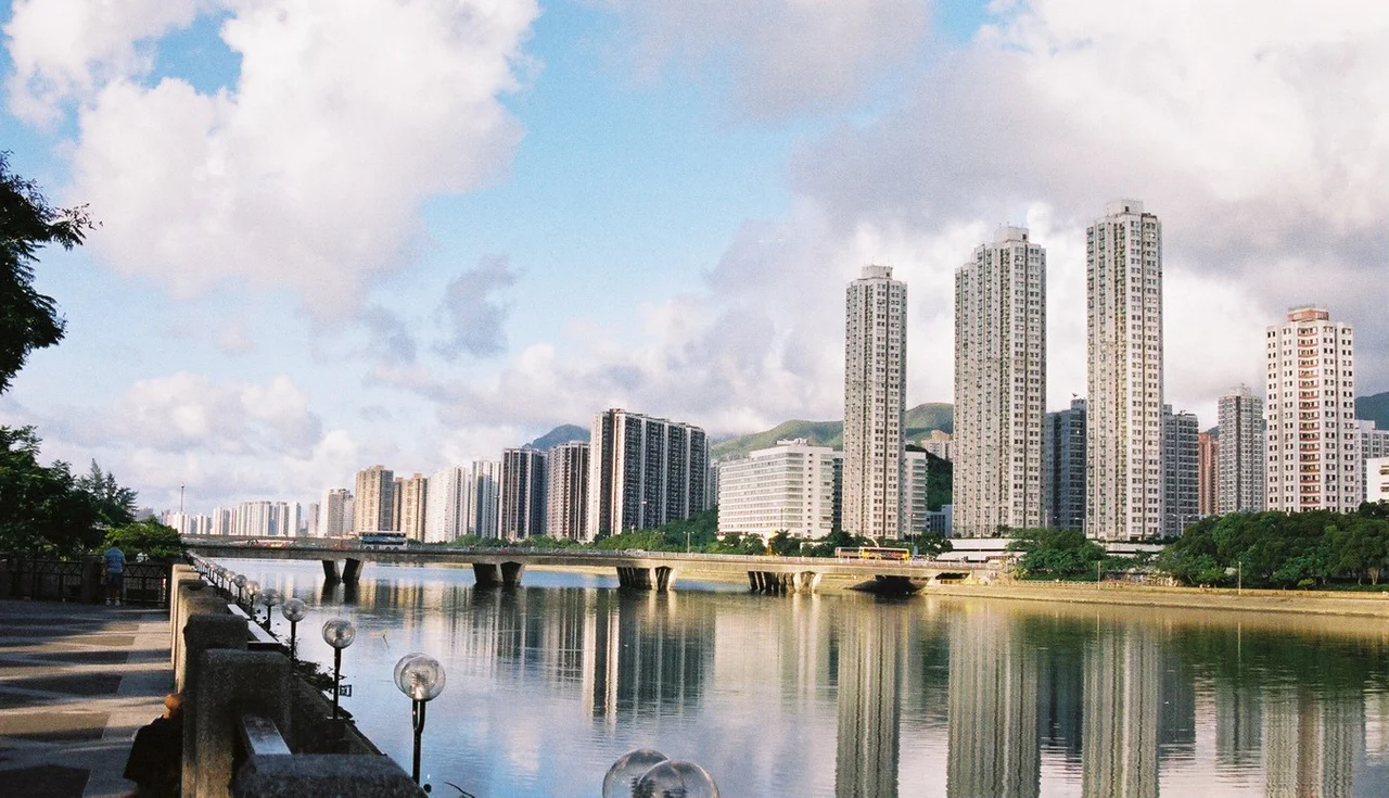

Sha Tin
In 1911, a Farman Mk II biplane named Wanda lifted off from flat agricultural land in a valley northeast of Kowloon. The pilot was Belgian, the crowd was curious, and the flight lasted only minutes — but Sha Tin had just made aviation history in Hong Kong. More than a century later, a full-size replica of that aircraft hangs in Hong Kong International Airport, a quiet tribute to what was then a sleepy rural backwater that few could have imagined would become one of the largest planned new towns in Asia.
From Sand Fields to New Town
Before colonial surveyors arrived in 1899, the valley cradled by hills near the Shing Mun River was known as Lek Yuen — literally 'source of clear water.' When George P. Tate and his assistant William John Newland mapped the New Territories, they likely mistook the name of the nearby Sha Tin Wai village for the entire area. The name stuck. 'Sand Fields' it became, and Sand Fields it remains, though today the sand lies buried under concrete and glass.
For centuries the district was farmland. Tai Wai Village, built in 1574 during the Ming Dynasty, still stands nearby as the oldest and largest walled village in the district. In 1956, a local businessman named Den Lau, son of the landowner Lau Hey Shing, established Sha Tin Hui — a small market township of five streets with shops, restaurants, and a post office. Typhoon Wanda badly damaged it in 1962. It was rebuilt, then demolished in 1979 as the government's transformation began in earnest.
The Making of a New Town
The Hong Kong government launched the New Towns Development Programme in 1973, and Sha Tin was one of its most ambitious targets. Engineers channeled the Shing Mun River, graded hillsides, and constructed residential towers by the hundreds. The 18-hectare central site — once Sha Tin Hui's market streets — became New Town Plaza, a massive shopping complex built by Sun Hung Kai Properties adjacent to the MTR East Rail station.
What emerged on both banks of the Shing Mun River was not just density but deliberate civic infrastructure: a town hall, public library, park, marriage registry, and the Prince of Wales Hospital, which was officially opened on 1 November 1982 but began receiving patients in May 1984, with roughly 1,400 beds serving the entire eastern New Territories. By the 2000s, two universities had established campuses here — the Chinese University of Hong Kong and Hang Seng University — giving the new town an academic anchor. The East Rail line now carries more than 730,000 passengers daily through Sha Tin station.
The Racecourse on Reclaimed Land
At the heart of Sha Tin's recreational geography sits its racecourse, occupying roughly 70 hectares of reclaimed flatland carved from the valley floor. On race days, the stands fill with tens of thousands of spectators; on non-race days, the infield Penfold Garden opens to the public as a quiet horticultural retreat. The contrast is distinctly Hong Kong — serene gardens enclosed within one of the territory's great entertainment venues.
Nearby, the 8-hectare Sha Tin Park opened in 1988, offering horticultural gardens, water features, an open plaza, and a bandstand along the riverfront. The cycle track that runs from Sha Tin toward Tai Po — the first of its kind in the territory when it opened in 1981 — remains the most popular cycling route in Hong Kong, drawing weekend riders along the Tolo Highway corridor. Dragon boat racing has taken place on the Shing Mun River every year since 1984.
Heritage Amid Transformation
Sha Tin manages an unlikely balance between mass development and cultural memory. The Hong Kong Heritage Museum, which opened at the end of 2000 in adjacent Tai Wai, is the largest museum in the territory, accommodating up to 6,000 visitors. Its exhibitions move between ancient New Territories history and vivid pop culture: Bruce Lee, Cantonese Opera, the wuxia novels of Jin Yong, and the development of Hong Kong film, television, and radio.
Scattered across the district, ancient villages persist alongside modern estates. On the south bank of the Shing Mun River, hamlets like Tsang Tai Uk and Sha Tin Wai have roots stretching back generations, their walled lanes now hemmed by apartment towers. Pilgrim routes wind up to the Ten Thousand Buddhas Monastery on the hillside above, where more than 12,000 Buddha statues line the staircases — a place of quiet persistence in a city that rarely pauses.
Sha Tin's local food culture is just as particular. Barbecued pigeon, a local specialty, draws visitors from across the city; the cooked food stalls in Wo Che Estate and Fo Tan are considered among the best in the territory for Cantonese home-style cooking.
Looking Toward the Border
Sha Tin's position in the New Territories gives it a particular relationship to the mainland. Since 2012, the district has felt spillover effects from parallel trading, as shoppers from Shenzhen crossed the border to buy goods — infant formula, household products — and resell them at a profit on the mainland. By 2014 the trade had become a flashpoint, with protests erupting in Sha Tin and neighboring towns. The debates that followed — about identity, belonging, and the border's meaning — revealed how deeply Sha Tin's suburban prosperity is connected to larger questions about Hong Kong's place between two worlds.
From the Air
Sha Tin sits at approximately 22.375°N, 114.183°E in a river valley northeast of Kowloon. From the air, the Shing Mun River is clearly visible threading between dense residential towers and the distinctive oval of the Sha Tin Racecourse. The valley is enclosed by Lion Rock to the southwest — a landmark peak also visible from much of Kowloon. The nearest major airport is Hong Kong International Airport (VHHH) on Lantau Island, about 40 minutes by road. A recommended approach for aerial viewing is from the south at 4,000–6,000 feet, tracking northeast along the river valley. The Chinese University campus on the hillside above Tolo Harbour provides another visual reference to the northeast.
Nearby Stories
- Chapel of St. Francis Xavier 3.5 km away
- Cuiheng 4.1 km away
- 2015 Shenzhen Landslide 16 km away
- Shunde 31 km away
- Wanshan Archipelago 37 km away
- Nanxiong Formation 96 km away
- Heyuan 149 km away
- Checheng Fu'an Temple 629 km away