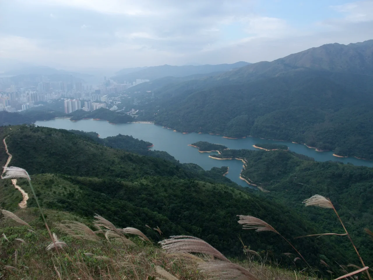

Shing Mun Reservoir
The dam that holds Shing Mun Reservoir was, when completed in 1937, the tallest dam in the British Empire. That record is long surpassed and largely forgotten, along with the royal name the reservoir once carried — Jubilee Reservoir, designated in 1935 to honor the Silver Jubilee of King George V. What remains is the water itself, 13.6 billion litres of it tucked into a valley between Tsuen Wan and Sha Tin, and the engineering, which was remarkable enough to earn an award from the Institution of Civil Engineers. A fortress commander from the seventeenth century gave the valley its name. A London engineering firm designed the dam. Seven Hakka villages were displaced to make it. The result is one of the most storied pieces of infrastructure in Hong Kong's New Territories — a place where history is literally submerged.
From Fortress Gate to Reservoir
The name Shing Mun means "fortified gate," and it comes from a military episode predating the reservoir by nearly three centuries. Between 1646 and 1659, Li Wanrong, a loyalist of the Southern Ming dynasty, led a force numbering in the thousands that controlled Kowloon and much of what is now the New Territories, collecting taxes, fortifying villages, and erecting a fortress in the lower Shing Mun River valley. The fortress gave the valley its identity. After the Qing dynasty consolidated control and the Kangxi Emperor lifted the Great Clearance in 1669, Hakka settlers moved into the area and built their lives around rice, tea, and pineapple cultivation. By the early twentieth century, seven villages populated the Shing Mun valley. They would not survive the decade that followed the 1923 water supply planning decision.
Engineering on Empire's Scale
Kowloon was growing faster than its water supply could accommodate. The Shing Mun Water Supply Scheme, formulated in 1923, proposed to solve the problem by damming the river valley and creating a large impoundment reservoir. London dam engineers Messrs Binnie, Deacon & Gourley drew the design. Construction began in 1933 on a dam 122 metres wide and initially 35 metres high, with a capacity of 4 billion litres. By the end of Phase Three in 1937, the Gorge Dam had been extended to 85 metres — the tallest dam in the British Empire at that time. The dam incorporated a distinctive engineering feature: a bellmouth overflow, a circular masonry structure rising from the water and connected to shore by a masonry footbridge. Conventional reservoirs use spillway weirs; Shing Mun's designers chose this rarer form instead. Geoffrey Binnie, who designed the overflow in 1935, received the Telford Premium Award from the Institution of Civil Engineers for the work. There is also a subsidiary structure, the Pineapple Pass Dam — 25 metres high, built of earth, rockfill, and concrete core — its name a remnant of what the valley once grew.
The Villages Below the Waterline
Seven villages once occupied the Shing Mun valley. Their inhabitants were resettled elsewhere in the New Territories — at Shing Mun San Tsuen, Wo Hop Shek, Pan Chung, and Kam Tsin Wai — before the reservoir filled. Some of the villages are now fully submerged. Others were not quite drowned: their remains, stone walls and house foundations, can be seen in the woods on the reservoir's banks when water levels drop in dry seasons. The area that became the Shing Mun Fung Shui Woodland, about 6 hectares near the northeastern end of the reservoir, was historically connected to Tai Wai Village, evacuated in 1929. Village custom had protected this grove under feng shui tradition for generations. It has been a Site of Special Scientific Interest since 1975. The Memorial Stone of Shing Mun Reservoir was declared a monument in September 2009, part of a batch of 41 pre-war waterworks structures declared simultaneously across six Hong Kong reservoir areas.
War on the Surrounding Hills
In December 1941, while the Japanese invasion force pushed across the New Territories, a defensive line called the Gin Drinkers Line ran through the hills above Shing Mun Reservoir. British colonial forces had constructed it as a delaying position. In practice, it was breached rapidly — the Shing Mun Redoubt fell within hours on the night of 9-10 December 1941, a collapse that accelerated the broader collapse of Hong Kong's defense. The remains of the Gin Drinkers Line, including tunnels and bunkers, survive on the hills above the reservoir today and can be explored on foot. The Japanese occupation that followed saw the park's trees cut down for fuel, a deforestation that the post-war reforestation program worked for decades to reverse. These layered histories — the drowned villages, the wartime defenses, the post-war restoration — give Shing Mun Reservoir a density of human experience unusual for what is, at surface level, a pleasant place to walk around a lake.
Trails Where Empires Met
Two of Hong Kong's most significant long-distance trails intersect at the reservoir. The Wilson Trail and the MacLehose Trail both run through the park, making the reservoir a crossing point for serious hikers working their way across the New Territories. The MacLehose Trail, all 100 kilometres of it running from Pak Tam Chung in the east to Tuen Mun in the west, passes along the reservoir on Sections 7 and 8. The Wilson Trail, running 78 kilometres from Stanley on Hong Kong Island to Nam Chung in the north, crosses over from Section 6 to Section 7 near the water. For hikers moving east-west or north-south across Hong Kong's green interior, Shing Mun Reservoir is an inevitable waypoint — a still surface reflecting whatever sky the Pearl River Delta chooses to offer on a given morning.
From the Air
Shing Mun Reservoir sits at 22.386°N, 114.147°E in the central New Territories between Tsuen Wan and Sha Tin. From altitude, the reservoir's elongated, irregular shape is immediately recognizable — wider at its northern end, narrowing toward the Gorge Dam at the south. The distinctive circular bellmouth overflow structure is visible in the water as a round island connected by a small bridge when water levels are sufficient. The urban edges of Tsuen Wan press close from the south. Nearest airport: Hong Kong International (VHHH), approximately 25 km to the southwest. Best viewed at 4,000 to 8,000 feet in clear weather; morning haze from the Pearl River Delta frequently reduces visibility before midday.
Nearby Stories
- Chapel of St. Francis Xavier 3.5 km away
- Cuiheng 4.1 km away
- 2015 Shenzhen Landslide 16 km away
- Shunde 31 km away
- Wanshan Archipelago 37 km away
- Nanxiong Formation 96 km away
- Heyuan 149 km away
- Checheng Fu'an Temple 629 km away