Shortland Islands
In 1788, a Royal Navy lieutenant named John Shortland was sailing home from Botany Bay. He had just helped deliver the First Fleet - the ships carrying Britain's first load of convicts to the newly founded penal colony in New South Wales - and was now looking for a safe northern route through Melanesia. On a chart he drew of an archipelago at the northwestern edge of the Solomons, he wrote his own surname. It stuck. The people who actually lived there had a name for the largest island - Alu - that had been in use for generations and would go on being used long after Shortland had gone home to write his report.
A Scatter of Islands
The Shortland group sits in Western Province of the Solomon Islands, its northern edge pressed against the international border with Bougainville. The inner ring - Shortland Island itself, plus Faisi, Balalae, Poporang, Magusaiai, and a handful of smaller offshoots - forms one administrative ward. The outer ring is split: the Treasury Islands (Mono and Stirling) to the southwest, and Fauro Island with its small satellites to the northeast. It is the kind of archipelago where the jungle comes down to the waterline and every island is its own small world with its own small beach. The border between Papua New Guinea and the Solomon Islands runs across the straits, but the fishermen who cross it to sell at markets in Buin tend not to carry passports, and the local police tend not to ask.
The German Era
In 1886 the German Empire and the United Kingdom divided the Solomon archipelago between them, with the initial boundary sitting further south than it sits today. The Shortlands, along with Choiseul and Santa Isabel, were on the German side. This arrangement lasted only until the Tripartite Convention of 1899, when Germany ceded the southern Solomons to Britain in exchange for concessions in Samoa. The Shortlands became part of the British Solomon Islands Protectorate, where they would remain until independence in 1978. That thirteen-year German interval left almost no administrative trace - Germany did not develop the islands in any serious way - but it created the odd legal lineage that still explains why Bougainville, a few miles north, belongs to a different country.
A Harbor the Allies Skipped
Japanese warships entered Shortland Harbor on 30 March 1942 and landed two special naval landing force platoons. There was no resistance. Within weeks the Japanese had set up a seaplane base, with moorings and fortifications in Tuha Channel and on the southeastern portion of Shortland Island, on Faisi, and on the northern part of Poporang. The facility was small but strategically placed - close enough to Guadalcanal to service reconnaissance flights, close enough to Bougainville to shelter between runs. As the war turned, the Allies considered invading the base in August 1943. They chose instead to bypass it for Bougainville and the lightly defended Treasury Islands. The Shortlands would stay under Japanese control until the Japanese surrender in 1945. The garrison was simply left to wither, raided occasionally by cruisers and carrier planes but never stormed. On 20 May 1944, the light cruiser USS Montpelier took light damage from return fire while bombarding Shortland, Poporang, and Magusaiai. The same operation launched four TDR-1 assault drones - crude, radio-controlled unmanned bombers, decades ahead of their time - at anti-aircraft positions on Poporang and Balalae.
After the Garrison Left
When the war ended, the seaplane base was dismantled and reclaimed by the forest. The fortifications on Poporang and Faisi are still there, half-swallowed by vines. The Shortlands today are a quiet constituency of Western Province, inhabited by a few thousand people across the main islands, mostly making their living from fish and copra. The closest urban center is Gizo, across the water; the closest economy they actually participate in is the Saturday market at Buin in Bougainville, where Shortland Islanders arrive with tuna and shellfish and head home with cocoa and trade goods. It is a bit of everyday internationalism that has been going on longer than any of the borders that supposedly divide the region - longer than the Germans, longer than the British, longer than the republics and autonomous regions of the present.
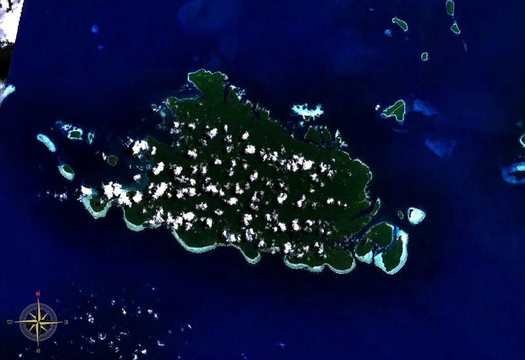
The View from Above
From cruising altitude the Shortlands look exactly like a satellite image of a volcanic archipelago: a fringe of deep green around pale coral shallows, with Shortland Island dominating and the rest scattered around it like a fleet caught at anchor. Flying over, you can see why Shortland the lieutenant thought this place looked like a sheltered harbor. You can also see why Japanese planners thought the same thing a century and a half later, and why Allied planners looked at the map and decided it was a target they could afford to leave alone. The people who lived here through all of that are still here.
From the Air
Coordinates 6.92 S, 155.88 E, just south of the Bougainville Strait in Western Province, Solomon Islands, against the PNG border. Recommended viewing altitude 4,000 to 7,000 feet for scale. No commercial airstrip on the Shortlands themselves; the nearest regional field is Ballalae (AGBA) on Balalae Island, a wartime strip still in limited use. Across the strait, Buin Airport (AYIQ) in Papua New Guinea is the nearest populated runway. Gizo's Nusatupe Airport (AGGN) lies about 100 nm southeast. Expect frequent tropical showers year-round; reef systems make visual navigation rewarding.
Nearby Stories
- Battle of Slater's Knoll 11 km away
- Raid on Choiseul 20 km away
- Japanese Seaplane Carrier Nisshin 30 km away
- Battle of the Treasury Islands 45 km away
- Battle of Vella Lavella (land) 62 km away
- Bougainville 78 km away
- Takuu Atoll 222 km away
- Woodlark Island 359 km away