The Mud That Swallowed a Town
On May 29, 2006, the ground near the town of Porong in East Java began to ooze. What started as a trickle of hot, grey mud quickly became a torrent -- 180,000 cubic meters per day at its peak, enough to fill seventy Olympic swimming pools every twenty-four hours. Two decades later, the mud has not stopped. The Sidoarjo mudflow, known locally as Lumpur Lapindo, holds the grim distinction of being the largest mud volcano on Earth, and its origin story remains one of the most bitterly contested questions in modern geology: was this a natural disaster triggered by an earthquake, or a man-made catastrophe caused by a drilling company's negligence?
A Drill Bit and a Fault Line
The sequence of events reads like a thriller with no clear villain. On May 27, 2006, a magnitude 6.3 earthquake struck Yogyakarta, roughly 250 kilometers to the southwest, killing over 6,000 people. The next day, PT Lapindo Brantas was drilling an exploration well called Banjar-Panji 1, targeting gas reserves deep in the carbonate rock beneath the Brantas basin. The well suffered a loss of circulation -- drilling mud pumped down the shaft vanished into underground openings instead of returning to the surface. Then came a "kick," an influx of pressurized formation fluid surging back up the wellbore. A day later, hot mud began erupting from the ground 200 meters away. The company blamed the earthquake. Independent geologists from the UK concluded the timing was coincidental and that the drilling itself had fractured underground rock or reactivated the Watukosek fault, creating a pathway for pressurized mud to reach the surface. The debate has filled scientific journals for years, but police investigators ultimately sided with the drilling hypothesis, noting that steel casing -- which could have prevented the blowout -- had never been installed.
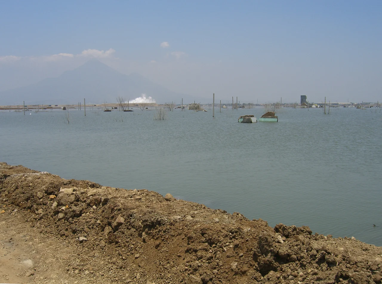
Villages Beneath the Grey
The human cost dwarfs the geological debate. Within months, entire neighborhoods vanished under a rising tide of hot, toxic sludge. Schools, mosques, factories, and homes disappeared one by one. Levees built to contain the flow were repeatedly breached. In Siring Barat, 319 families were displaced; in Kelurahan Jatirejo, hundreds more. Workers attempting to manage the eruption suffered severe burns from sudden bursts of hot gas. The main highway linking Surabaya to Probolinggo was buried and rerouted. Even the railway running alongside the affected area became dangerous -- methane seeping from the ground meant a tossed cigarette could trigger an explosion. By mid-2010, residents had received less than 20 percent of the compensation they were promised, and legal action against the company had stalled. For the displaced families living in temporary housing and boarding rooms, the mud had taken not just their homes but their livelihoods, their documents, and their sense of permanence.
Corporate Maneuvering and Accountability
The Bakrie Group, whose subsidiary PT Lapindo Brantas held the operating concession, mounted an aggressive defense. Senior executives told parliament that their company's presence near the eruption was coincidental and that compensation should fall to the government. When that argument faltered, the Bakrie Group attempted to sell Lapindo Brantas to an offshore entity for two dollars -- a transaction that was blocked. Courts ordered the company to pay approximately 2.5 trillion rupiah, about $277 million, to victims, plus an additional 1.3 trillion rupiah toward stopping the flow. Analysts speculated the group would pursue bankruptcy rather than pay the estimated $1 billion cleanup cost. Meanwhile, the environmental organization WALHI filed suit against not only the company but also President Susilo Bambang Yudhoyono and multiple cabinet ministers, arguing that government oversight had failed catastrophically. Thirteen Lapindo executives and engineers eventually faced criminal charges.
The Mud That Will Not Stop
Scientists initially estimated the flow would continue for 25 to 30 years. By 2013, international researchers monitoring the site reported that the eruption was losing pressure and had shifted from a steady flow to a pulsing pattern -- a sign, they believed, that the geological forces driving it were weakening. Predictions that the flow might cease by 2017 proved optimistic. By 2016, tens of thousands of liters of mud contaminated with heavy metals were still leaking into rivers, and the site had attracted a macabre new industry: disaster tourism. Visitors climb a staircase to a viewing platform overlooking the vast grey expanse -- submerged rooftops, gas plumes rising from excavator-scarred terrain, and the remnants of a community that once held 40,000 residents. The mud volcano has also been slowly collapsing under its own weight, with satellite data showing parts of the affected area subsiding while others rise, as though the earth itself is still trying to settle the argument about what went wrong beneath Porong.
Seen from Above
From the air, the Sidoarjo mudflow is unmistakable. A vast grey scar stretches across the landscape south of Surabaya, ringed by earthen levees that look fragile against the scale of what they contain. Steam plumes mark the active vents at the center. The contrast between the orderly grid of surrounding neighborhoods and the featureless mud plain is stark -- a reminder that this was once a densely populated district with its own rhythms and routines. The nearby Arjuno-Welirang volcanic complex rises to the south, a reminder that East Java sits atop some of the most geologically restless ground on the planet. For twenty years, this patch of earth has been doing something no one can fully explain or stop.
From the Air
Coordinates: 7.53S, 112.71E. The mudflow zone is visible as a large grey-brown area south of Surabaya, ringed by levees. Best viewed at 5,000-10,000 ft AGL. Nearest major airport: Juanda International Airport (WARR), approximately 14 km north. The Arjuno-Welirang volcanic complex is visible to the south-southwest. Steam plumes may be visible from the active vents in clear weather.
Nearby Stories
- The Kedopok War: When Probolinggo Rose Against Its Buyer 5.5 km away
- The Floating Colossus of Surabaya 6 km away
- Purwodadi Botanical Garden 9.7 km away
- Madura: Salt, Bulls, and the Island That Emptied Itself 21 km away
- Where Teak Meets Oil 30 km away
- The Train Builders of Madiun 71 km away
- The School That Gave Itself Away 75 km away
- Where Three Worlds Meet: The Great Mosque of Sumenep 89 km away