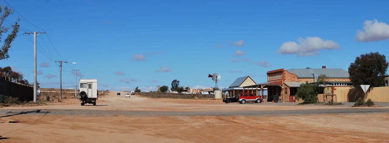

Silverton, New South Wales
When the people of Silverton left, many of them took their houses with them. The homes were simple things of iron and canvas, easy enough to pull down, load on a dray and cart 25 kilometres down the road to Broken Hill, where the real fortune had just been found. A town of 3,000 in the 1890s dwindled to a few hundred, then to a handful. Today about 50 people live here, in a scatter of stone buildings on the red plains of far western New South Wales. Silverton should have vanished completely. Instead it became something stranger and more durable than a mining town: a film set, an artists' refuge, and one of the most recognisable patches of outback in the world.
Silver and a Barrier
This is old country, long held by Aboriginal people whose presence along these waterless ranges shifted with the seasons and the scarce water - until disease and the pressure of European settlement drove them from their lands, as it did across so much of the continent. The first European to pass through was the surveyor Thomas Mitchell in 1841. Three years later Charles Sturt, hunting for a fabled inland sea, named the Barrier Range - so called because it barred his way north. Burke and Wills crossed this country on their doomed 1860-61 expedition, basing themselves at nearby Menindee. Then, in the 1870s, prospectors struck rich silver, and a town erupted from the saltbush. Silverton was proclaimed in 1880, and within a decade it boomed.
The Town That Moved Away
At its height Silverton had a municipal council, formed in October 1886, and grand civic ambitions to match a population approaching 3,000. To shift the ore concentrates more efficiently than horse and dray could manage, the Silverton Tramway opened in 1888, a railway running to the South Australian border where government trains hauled the ore on to Port Pirie for smelting. But the high-grade silver around Silverton ran thin fast - and just down the road, at Broken Hill, miners had hit a silver-lead-zinc ore body of staggering richness. The Broken Hill lode would become one of the great mineral deposits on Earth. Silverton could not compete. The population collapsed, the portable houses rolled away, and by 1901 fewer than 300 people remained where thousands had lived.
A Picnic Train and a Tragedy
Even diminished, Silverton stayed close to Broken Hill's heart as a place for outings and recreation, and that link runs through one of the strangest events in Australian history. On New Year's Day 1915, a picnic train packed with Broken Hill families was steaming toward Silverton when two men opened fire on it from beside the line - an attack that left several dead and shocked the nation in the early months of the First World War. For decades afterward, Penrose Park outside town served as the district's great picnic ground; mining companies poured money into its sporting fields in the 1930s and 40s, and a single employees' picnic in 1941 drew a fifth of Broken Hill's entire population. The road out to it became one of the first sealed roads in the region, worn smooth by convoys of family cars.
The Most-Filmed Ghost Town
Silverton's second life began behind a camera. The clear desert light, the weathered colonial stone and the cinematic emptiness proved irresistible to filmmakers, and by 2007 the town had appeared in more than 140 films and commercials. The roll call is remarkable for a place of 50 people: the nightmarish Wake in Fright, the wartime drama A Town Like Alice, the horror film Razorback, and most famously Mad Max 2, whose battered interceptor still sits outside the Silverton Hotel. That pub, its walls layered with memorabilia, is the town's beating heart. Artists settled too, drawn by the same light the film crews loved, opening galleries like John Dynon's among the ruins. Most of old Silverton has crumbled to rubble, but the Hotel, the former gaol and the old stone school - where the poet Dame Mary Gilmore once taught - still stand. Each August the town swells again, when campers fill Penrose Park for the Mundi Mundi Bash out on the nearby plains. A ghost town, perhaps - but a remarkably lively one.
From the Air
Silverton sits at 31.88 degrees south, 141.22 degrees east, on the arid plains of far western New South Wales, about 25 km northwest of Broken Hill near the foot of the Barrier Ranges. From the air it appears as a small, sparse cluster of buildings and dirt roads marooned in vast red-brown saltbush country - tiny against its surroundings, with the rugged line of the Barrier Ranges rising to the north and east. Just to the west the land flattens dramatically into the Mundi Mundi Plains, and the white turbines of the Silverton Wind Farm strung along the ranges make a useful navigation marker. The larger grid and mine headframes of Broken Hill lie a short hop southeast. Nearest major airport is Broken Hill (YBHI), about 25 km southeast. Recommended viewing altitude 3,000-5,000 ft to make out the small township and its setting against the range-and-plain landscape. Visibility is generally excellent in this dry climate, the famed clear light being the very quality that draws filmmakers; summer heat haze and dust storms are the main factors that can reduce it.
Nearby Stories
- Mount Gipps Station 38 km away
- Radium Hill 48 km away
- Kinchega Woolshed 71 km away
- Mutawintji National Park 86 km away
- Menindee, New South Wales 88 km away
- Mount Chambers Gorge 148 km away
- Wilpena Pound 198 km away
- Redruth Gaol 229 km away