Southern region (Eritrea)
In April 1996, five years after Eritrean independence, the new government redrew the country's internal boundaries. Six regional zobas replaced older provincial divisions. The largest by population was the Southern region - a merger of two ancient territories called Seraye and Akele Guzai, each of which had its own dynasties, dialects, and memories stretching back to the Aksumite period. The merged region runs along the Ethiopian border, climbs to 3,018 meters at Mount Soira - the highest point in the country - and contains roughly a million people, many of whom still identify themselves first by their historical province and only second by their modern administrative one.
A Highland Region
The Southern region sits mostly on the Eritrean highland plateau, that corrugated expanse of basalt mesas, deep canyons, and cultivated terraces that defines the heart of the country. Elevations mostly run between 1,500 and 2,500 meters. The capital is Mendefera, known historically as Adi Ugri. Other towns include Adi Keyh, Mayduma, Adi Quala, Dekemhare, Debarwa, Segeneyti, Areza, and Senafe. Much of the region's 8,000 square kilometers is fertile enough to support agriculture - the soil is actually conducive to cultivation, unlike the salt-crusted lowlands to the east. Rainfall averages 508 millimeters per year, delivered in the usual two-season pattern. The climate moderates with altitude; cold months can bring frost, summer highs stay manageable. This is the core of traditional Tigrinya-speaking settlement in Eritrea.
Ancient Ground
The archaeological sites of Metera, Qohaito, and Mendefera all lie in the region. Qohaito, perched on an escarpment near Adi Keyh, was a major urban center during the Aksumite period, with stone-built temples, cisterns, and what appear to be palaces whose functions are still being worked out by archaeologists. Metera, near Senafe, has yielded stelae, ruined temples, and inscriptions in Ge'ez and Sabaean that link this region to the trade networks connecting the ancient Red Sea coast with the Ethiopian highlands and south Arabia. Pre-Aksumite inscriptions here reference the kingdom of D'mt, a first-millennium BCE polity with demonstrable cultural and political ties across the Red Sea. These sites are less visited than their Ethiopian counterparts at Axum, but they represent a northward extension of the same civilization.
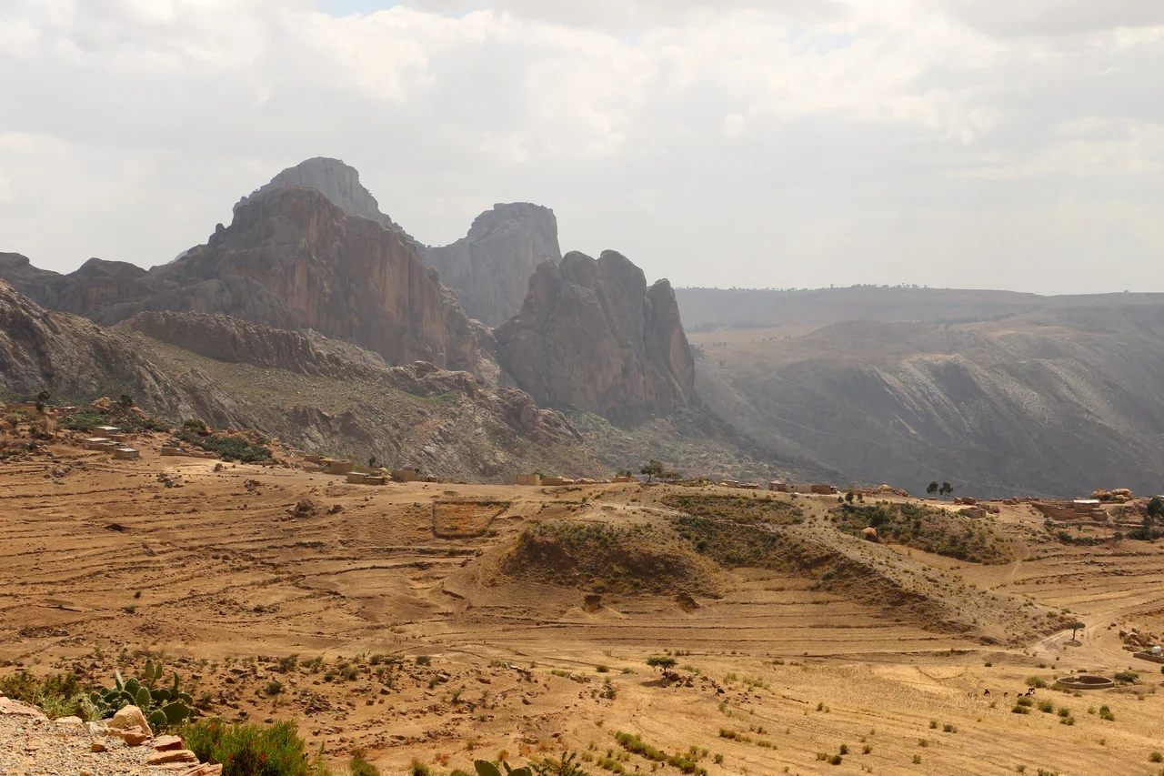
Mount Soira
East of Senafe, the highland edge rises to Mount Soira, also called Emba Soira, at 3,018 meters the highest point in Eritrea. It is not a dramatic peak in the Simien or Kilimanjaro sense - more a broad basaltic shoulder emerging from an already elevated plateau - but from its summit the land drops away toward the Red Sea to the east and the Ethiopian border to the south. The view on clear winter days reaches well into both countries. The mountain is remote. Access routes are limited. What hikes exist are informal, undertaken by residents more than by tourists, many of whom are still rare in contemporary Eritrea.
Demographics and Daily Life
As of 2005, the region held 952,100 people, up from 839,700 in 2001. Population density ran at 119 persons per square kilometer, concentrated in the villages and small towns of the plateau. Total fertility was 5.7 children per woman - the highest of any Eritrean region, reflecting the stable agricultural base that can support large families. Literacy was 62.8 percent for men, 41.9 percent for women. Agriculture employed more than half the workforce at 52.1 percent, with sales and services a distant second at 19.7 percent. The twelve subregions - Adi Keyh, Adi Quala, Areza, Maidima, Debarwa, Dekemhare, Mai-Mne, Mendefera, Segeneiti, Senafe, Tera-Emni, Tsorona - map onto ancient villages that many residents' families have lived in for generations, sometimes for centuries.
The Border That Was Not
The border with Ethiopia, south of the region, has been the site of one of the most tragic conflicts of recent African history. The Eritrean-Ethiopian war of 1998 to 2000 killed tens of thousands and devastated communities on both sides. Tsorona and Senafe were battlegrounds. The 2000 Algiers Agreement was meant to resolve the border but did not, and for most of the next two decades the two countries remained in a state of no-peace-no-war. A 2018 rapprochement briefly opened the border, then circumstances closed it again. For residents of villages like Adi Quala that are just kilometers from Ethiopia, the border is not an abstraction but a daily fact that determines whether they can visit relatives, trade, or move livestock to seasonal pastures that happen to lie on the other side.
From the Air
The Southern region from altitude looks like the heart of Eritrea - terraced slopes, patchwork fields, stone villages, the twisting roads that connect them. The plateau drops away to the east toward the Red Sea and to the south toward the border. Mount Soira rises subtly in the east, more a regional high point than a dominating peak. Asmara, the national capital, sits just north of the region in what is now Maekel. Travelers approaching from the south cross the border near Senafe; travelers coming from the coast climb the winding road up from Massawa and reach the plateau through this region. It is the part of Eritrea where Eritrean identity feels most rooted in continuity, in soil, in the particular rhythms of a highland agricultural life.
From the Air
Located at 14.80°N, 39.00°E on Eritrea's southern highland plateau. Mendefera is the regional capital. Recommended viewing altitude FL200-260. Mount Soira (3,018m) east of Senafe is Eritrea's highest peak. Asmara International Airport (HHAS) approximately 60 kilometers north serves the region. Expect stable winter flying conditions, with afternoon convective activity possible in summer months. Rough terrain throughout - maintain terrain clearance.
Nearby Stories
- Kagnew Station 25 km away
- Italian Eritrea 25 km away
- Obelisk of Axum 53 km away
- Adulis 55 km away
- Battle of Agordat (1941) 67 km away
- Dedebit Elementary School airstrike 69 km away
- Gash-Barka Region 99 km away
- Danakil Depression 107 km away