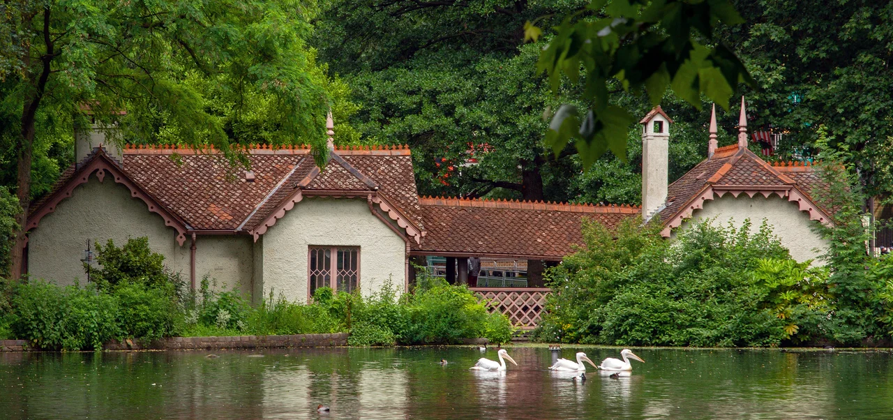

St James's Park
A pelican has lived in St James's Park since 1664, when a Russian ambassador sent a gift of birds to Charles II. The descendants of those pelicans are still here, mostly clip-winged, mostly polite, occasionally - and famously, in 1999 - eating other waterfowl whole. They preside over a 23-hectare patch of central London bounded by Buckingham Palace at one end, Whitehall at the other, with The Mall running along its northern flank as a processional avenue and Birdcage Walk closing the south. It is the oldest Royal Park in the city, the eastern terminus of a near-continuous green chain that stretches to Kensington Gardens, and the place where the British monarchy's official ceremonial geography begins.
How Henry VIII Got It
In 1532, Henry VIII bought a patch of marshland from Eton College through which a small river called the Tyburn ran. He needed it because he had just acquired Cardinal Wolsey's nearby York Place and wanted to upgrade it from cardinal's residence to royal palace - a transformation that produced Whitehall and required hunting grounds. Henry drained the marsh, enclosed it for deer, and built a small hunting lodge at one end that grew into St James's Palace. Seventy years later James I, never one for understatement, ordered the park drained again and stocked it with exotic animals: camels, crocodiles, an elephant, and birds kept in aviaries. The southern footpath that still bears the name Birdcage Walk runs through the spot where his cages stood.
Charles II and the Lechery Years
Charles II returned from exile in France in 1660 with a head full of Versailles. He had the park redesigned in the formal French style, probably by Andre Mollet, with a long ornamental canal 775 metres by 38 metres slicing straight through its middle. He opened it to the public - a decision more revolutionary than it sounds - and proceeded to use it as a private playground. He walked through it daily, fed the ducks, gossiped with passersby, and entertained his various mistresses there, Nell Gwyn included. The park rapidly acquired a reputation for activities that were less than discreet, as immortalised in John Wilmot, 2nd Earl of Rochester's poem 'A Ramble in St James's Park' - a piece of late seventeenth-century satire so anatomically explicit that it took until the twentieth century before respectable editions stopped omitting most of it. By 1710 the German traveller Zacharias Conrad von Uffenbach was reporting that cows grazed the park and you could buy fresh milk at a stand called the Lactarian. The lechery and the cows coexisted, apparently amicably.
John Nash Romances the Canal
The current shape of the park dates almost entirely to 1826-27, when the Prince Regent - soon to be George IV - commissioned the architect John Nash to romanticise everything. Nash converted Charles II's straight canal into the irregular, naturally-curving lake that exists today. He replaced formal avenues with winding paths. He turned The Mall, which had been a private royal route, into a grand processional avenue connecting Buckingham House (about to be expanded into Buckingham Palace) with Trafalgar Square. Marble Arch was built as the entrance to the palace, then moved to Oxford Street in 1851 when it turned out not to fit through the new gates. The Victoria Memorial - a wedding cake of marble and gilded bronze - was erected at the palace end between 1906 and 1911. Walk west along The Mall today and you walk the route Nash drew. Walk around the lake and you walk a Romantic reinvention of a French canal that was a Tudor hunting ground that was a medieval marsh.
The Bomb-Disposal Birdkeeper of Duck Island
At the eastern end of the lake sits Duck Island, named for its tenants and once, in the late nineteenth century, used by Scotland Yard as a bomb disposal facility. The duties of the resident birdkeeper expanded accordingly: feed the pelicans, count the swans, mind the explosives. The island now houses the lake's water-treatment pumps and the headquarters of the London Parks and Gardens Trust. Beside it the Blue Bridge crosses the lake, offering what most photographers consider the best view of Buckingham Palace - the white facade framed by trees, the Victoria Memorial at the end of the avenue. Looking east the view becomes a tour of British power: Horse Guards Parade, the Old War Office, Whitehall Court behind, then the London Eye, the Shell Tower, and the Shard piercing the horizon. The park's trees are a deliberately diverse collection - London planes, scarlet oaks, black mulberries, a single fig. The pelicans, mostly, behave. A national memorial to Elizabeth II is being designed by Norman Foster for the park itself - the next ceremonial layer in a landscape that has been adding ceremony since 1532.
From the Air
Located at 51.5025°N, 0.135°W in the City of Westminster, immediately east of Buckingham Palace and immediately west of Horse Guards Parade. Recommended viewing altitude 2,000-2,500 feet. London City (EGLC) lies 6 nm east, Heathrow (EGLL) 13 nm west. The Victoria Memorial's gilded statue and Buckingham Palace's white facade are visible at the park's western end; the London Eye and Big Ben provide unmistakable references just beyond the eastern boundary.
Nearby Stories
- Battle of Britain, Northfleet 1.1 km away
- Bayham Old Abbey 5.4 km away
- Catharine Macaulay 6.4 km away
- Hatfield rail crash 8.8 km away
- Chequers 8.9 km away
- Chelmsford Cathedral 10 km away
- Queen Victoria Hospital 13 km away
- Fishbourne Roman Palace 36 km away