The Island That Shouldn't Exist
The Portuguese sailors who first reached Sulawesi in 1523 thought they had found an archipelago. From any single coastline, the island's four sprawling peninsulas -- separated by deep gulfs and connected by a narrow mountainous core -- looked like separate landmasses. They were wrong about the geography but right about the strangeness. Sulawesi is not one island in any simple geological sense. It is a collision of fragments: pieces of the Asian continental shelf driven into shards of the Australian plate, with volcanic island arcs from the Pacific welded onto the edges. The result is the world's eleventh-largest island, covering 186,000 square kilometers, shaped roughly like the letter K, and home to one of the most peculiar collections of living things on the planet.
Assembled from Continents
Sulawesi's K-shaped outline is a geological accident with no parallel. About 45 million years ago, the opening of the Makassar Strait tore the western portion away from Borneo. Later, micro-continental fragments that had once been part of the Australian margin collided from the east. Volcanic island arcs slammed in from the Pacific to form the northern and eastern peninsulas. The collision continues -- active volcanoes like Mount Lokon and Soputan punctuate the northern Minahasa Peninsula, and the deadly earthquakes of 2018 and 2021 are reminders that the assembly is not finished. Because of these multiple tectonic origins, Sulawesi sits at the center of Wallacea, the biogeographical twilight zone between Asia and Australia where the fauna is neither wholly one nor the other. Even the island's name may encode its fractured geology: Sulawesi possibly derives from sula (island) and besi (iron), a reference to the rich iron deposits around Lake Matano that were smelted into trade goods for centuries.
Hands on the Wall
In January 2026, researchers announced that hand stencils and human figures in a cave on Muna Island, off the southeastern coast of Sulawesi, had been dated to at least 67,800 years ago, making them the oldest known rock art in the world. The images were created by blowing pigment over hands pressed against limestone, leaving ghostly negative outlines -- one hand deliberately reshaped to look more claw-like, a stylistic choice whose meaning is lost. These discoveries capped a decade of revelations from the Maros-Pangkep karst on the southwestern peninsula. In 2024, archaeologists identified a hunting scene at Leang Karampuang painted at least 51,200 years ago -- the oldest known figurative artwork, depicting human-like figures interacting with a wild pig. A warty pig from Leang Tedongnge, dated to at least 45,500 years, had previously held that record. Older still were the stone tools found near Soppeng, dating to at least 1.04 million years ago and possibly 1.48 million, evidence that archaic humans reached Sulawesi long before anyone painted anything.
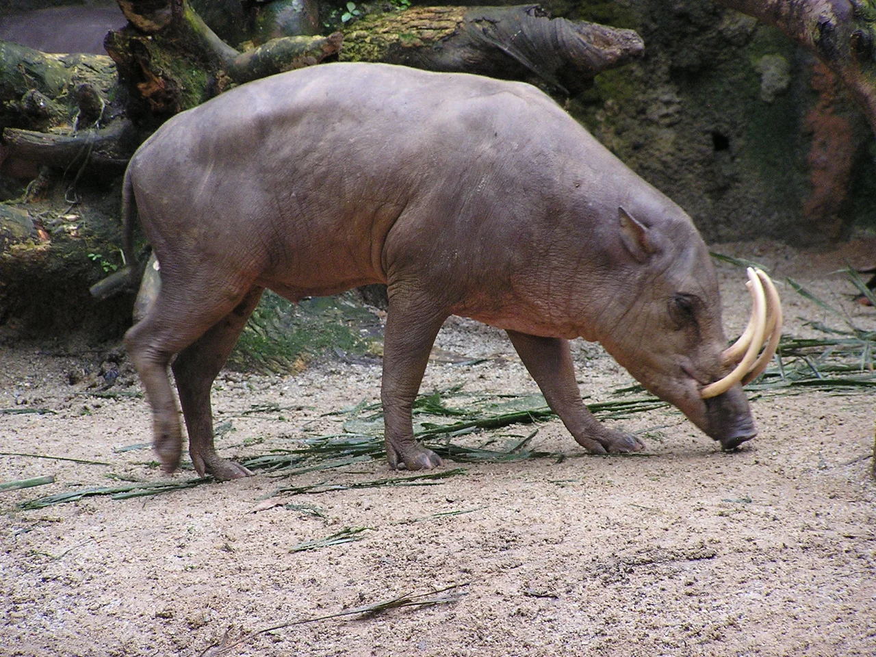
Evolution's Workshop
Sulawesi's isolation created an evolutionary laboratory without equivalent. Of its 127 known native mammal species, 62% are found nowhere else on Earth. The anoa, a dwarf buffalo standing barely three feet tall, is the island's largest land mammal. Babirusas -- pigs whose upper tusks curve backward through the snout and arch over the forehead -- are so bizarre that early European naturalists doubted the first specimens were real. Seven species of tarsier haunt the forests at night, tiny primates with enormous eyes that can rotate their heads nearly 180 degrees. Cuscuses, marsupials of Australian origin, share the canopy with macaques of Asian descent -- a cohabitation that makes sense only on an island assembled from both continents. In the waters offshore, a living coelacanth was discovered, a fish thought extinct for 66 million years. Even the freshwater lakes harbor extraordinary diversity: Lake Matano, 590 meters deep and one to two million years old, contains endemic shrimp and snail species so colorful they fuel a global aquarium trade.
Kingdoms and Collisions
Human history on Sulawesi is almost as layered as its geology. By the 14th century, maritime kingdoms like Gowa and Luwu were trading with the Javanese Majapahit empire. The Portuguese arrived in 1523, drawn by rumors of gold. The Dutch followed in 1605, and by 1669, after defeating the Makassar kingdom of Sultan Hasanuddin at the Treaty of Bongaya, they controlled the island's trade through the Dutch East India Company. Their conquest was enabled by Arung Palakka, a Bugis warlord whose alliance with the colonizers made his kingdom of Bone the regional power -- a collaboration whose consequences shaped Sulawesi for centuries. The Bugis, today the most numerous ethnic group, were legendary seafarers whose trading praus reached as far as northern Australia. Islam took hold in the lowlands from the early 17th century, starting with Luwu in February 1605 and Gowa-Talloq in September of that year. Christianity arrived in the north around Manado and later among the highland Toraja.
The Vanishing Forest
By 2007, 80% of Sulawesi's forest had been lost or degraded, and 99% of its wetlands were damaged. Lowland forest, the richest habitat on the island, was hit hardest -- cleared for logging, agriculture, and increasingly for the nickel mining that feeds the global battery supply chain. The maleo, a chicken-sized megapode that buries its eggs in volcanically heated sand for incubation, is endangered. Both species of anoa are declining, with perhaps 2,500 of each remaining in the wild. The coral reefs of Bunaken, proposed as a UNESCO World Heritage Site, face pressure from fish bombing and poaching. Sulawesi's six provinces contain more endemic species per square kilometer than almost anywhere else on Earth. What took millions of years of tectonic collision and evolutionary isolation to produce is being dismantled in decades, and the outcome is still being written across every peninsula.
From the Air
Sulawesi is centered approximately at 2S, 121E, with its four peninsulas extending in different directions. The island spans roughly 800 km north-south and 500 km east-west. Major airports include Sultan Hasanuddin International (WAAA) serving Makassar in the south, Sam Ratulangi International (WAMM) serving Manado in the north, and Mutiara SIS Al-Jufrie (WAML) serving Palu in central Sulawesi. The island's distinctive K-shape is clearly visible from high altitude. Terrain is extremely mountainous in the interior, with active volcanoes on the northern Minahasa Peninsula. Expect significant convective weather, especially during monsoon season (November-March). The deep gulfs of Tomini, Tolo, and Boni are major visual landmarks separating the peninsulas.
Nearby Stories
- The Town the Lake Made Twice 38 km away
- The Entertainers of Bada Valley 41 km away
- The Spirit Boats of Pokekea 42 km away
- The Nickel Furnace of the Electric Future 84 km away
- Central Sulawesi: Where the Earth Remembers 85 km away
- The Scholar's Gift: Palopo Old Mosque 90 km away
- Kepulauan Togean: The Islands Where Jellyfish Forgot How to Sting 161 km away
- The Hidden Archipelago of Tomini 192 km away