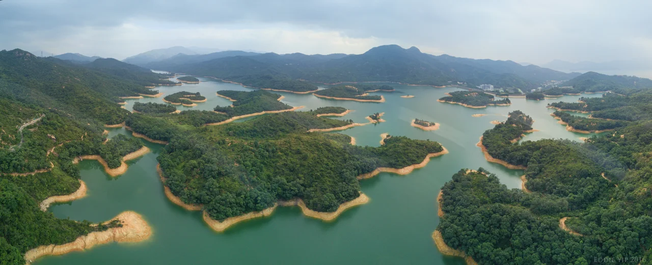

Tai Lam Chung Reservoir
When the water level drops low enough, rooftops emerge from the reservoir. The villages that were flooded to build Tai Lam Chung Reservoir — Tai Lam Village, Tai Wai Village, Kan Uk Tei Village, Wu Uk Village — are still down there, preserved in the cold dark below a surface that locals have taken to calling the Thousand Island Lake of Hong Kong. The nickname comes from the scattered islands of vegetation and hillside that poke above the waterline, mimicking the famous Zhejiang lake in miniature. It is a beautiful place built on a difficult decision: that some people had to move so that millions could drink.
A City Running Dry
By the early 1950s, Hong Kong's population was surging. Refugees from the Chinese Civil War had poured into the colony; industry was expanding; the demand for clean, reliable water was growing faster than existing infrastructure could supply it. The colonial government's answer was to build. Construction on Tai Lam Chung Reservoir began in 1952 in a valley of the same name in the western New Territories, and the project was completed in 1957.
The main dam spans the Tai Lam Chung Valley; three supplemental dams cross adjacent valleys to maximize the catchment area. When full, the reservoir holds approximately 21 million cubic metres of water. It was the first reservoir Hong Kong built after World War II — a statement of intent about what kind of place the colony intended to become. The engineering ambition was real, even as it came at a cost to the people who already called the valley home.
The Villages That Were Moved
The government had to relocate residents of the Tai Lam Villages and Kan Uk Tei Villages before the valley could be flooded. Families who had farmed and lived in the valley for generations were resettled to Tai Uk Wai Villages, a process that required them to leave fields, graves, and structures behind. Then the dam gates closed, and the water rose.
Four villages disappeared under the new lake: Tai Lam, Tai Wai, Kan Uk Tei, and Wu Uk. The people who had lived there were not erased from history — they were moved into the surrounding landscape — but the physical places they had inhabited were. What the reservoir created was both infrastructure and an act of displacement, the kind of trade-off that built much of Hong Kong's modern water system. The submerged rooftops are a quiet record of that bargain, surfacing only when the rains have been scarce.
Water from the Mainland
The reservoir alone was not enough. By the late 1960s, Hong Kong was facing water shortages severe enough to prompt rationing. The solution came from across the border: in the late 1960s, the Hong Kong government began importing water from the Dongjiang river in Guangdong Province, a supply arrangement that remains in place today and provides the majority of Hong Kong's freshwater.
The Dongjiang water was piped into Tai Lam Chung Reservoir, which became a key node in the distribution system — receiving, storing, and releasing water as demand required. What had been built as a local catchment facility became a critical piece of cross-border infrastructure. The reservoir's importance in Hong Kong's water supply system reflects something essential about the city: its scale of ambition has always outpaced what its own geography can provide.
The Thousand Island Lake of Hong Kong
The landscape that visitors and hikers find today is unexpectedly beautiful. Tai Lam Country Park surrounds the reservoir entirely, protecting the hills and forests from development and keeping the water catchment area clean. The trails that wind through the park offer views of the reservoir from above — a blue-grey expanse of water, irregular in outline, dotted with vegetated islets that give it the Thousand Island Lake comparison.
At low water, the analogy deepens in an unexpected direction. The visible remnants of flooded structures serve as accidental monuments — stone walls and building foundations rising from the shallows, testimony to the villages that once occupied the valley floor. The reservoir is both a working piece of infrastructure, handling water supply for millions of people, and a kind of inadvertent memorial to the communities it displaced. Fishing is permitted here; hiking trails circle the perimeter; the park is busy on weekends with families from Tuen Mun and Yuen Long who come for the views and stay for the quiet.
From the Air
Tai Lam Chung Reservoir lies at approximately 22.39°N, 114.03°E in the western New Territories, within Tai Lam Country Park, about 12 km northeast of Hong Kong International Airport (VHHH). From the air, the reservoir is clearly visible as the large irregular body of water surrounded by forested hills west of Tuen Mun and south of Yuen Long. The Tai Lam Tunnel passes underground through the country park just to the north. Recommended viewing altitude is 2,500 ft or higher, as the surrounding hills rise to over 400 m. VHHH is the primary regional airport; approach paths do not traverse this area directly.
Nearby Stories
- Chapel of St. Francis Xavier 3.5 km away
- Cuiheng 4.1 km away
- 2015 Shenzhen Landslide 16 km away
- Shunde 31 km away
- Wanshan Archipelago 37 km away
- Nanxiong Formation 96 km away
- Heyuan 149 km away
- Checheng Fu'an Temple 629 km away