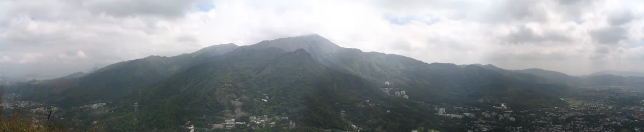

Tai Mo Shan
On most days, you cannot see the top. Clouds settle over Tai Mo Shan — Big Hat Mountain, as the name translates — and the peak disappears into grey. In winter, stratus fog keeps it wrapped for days at a stretch. In summer, cumulus towers build above it in the afternoon heat. The weather station established on the summit in 1997 has never recorded a temperature above 29.5 degrees Celsius, despite the tropical latitude. Since it became operational, the summit has stayed cool enough that it has also never topped 30 degrees. Hong Kong's highest mountain, at approximately 956 meters above mean sea level, exists in its own microclimate — colder, mistier, more remote than anything the city below would suggest.
A Volcano That Still Breathes
Tai Mo Shan is an inactive volcano of Jurassic age, formed when the region that would become Hong Kong was far more geologically turbulent than it is today. The dominant rocks are coarse ash crystal tuff — the compressed residue of ancient eruptions. Granodiorite, a type of granite that intruded into those volcanic rocks approximately 150 million years ago, forms much of the mountain's core.
Near the summit, a smaller hill called Kwun Yam Shan still vents warm air through cracks in the rock that connect, somehow, all the way to the mantle. Locals call the warm-air holes "hot pots." In cold weather, when the temperature at the summit drops toward freezing, the expelled air — somewhere between 13 and 21 degrees Celsius — is clearly visible as it rises. The phenomenon has a name: dragon's breath. It is not metaphor. On a cold January morning on Tai Mo Shan, with the city invisible below the cloud line and warm air rising from the earth, the description earns its keep.
The Mountain That Blocks the Monsoon
Tai Mo Shan sits at approximately the geographical center of the New Territories, and its position matters beyond the scenic. At 956 meters, it is tall enough to intercept the summer monsoon from the south, casting a rain shadow across the northern and northwestern New Territories that makes those areas measurably drier than the windward slopes. The whole massif, known during the Ming and Qing dynasties as Kwun Fu Mountain — named after a salt field in what is now Kowloon Bay — extends over 350 square kilometers.
The range stretches from Tai Lam Chung Reservoir to the west all the way to Ma On Shan in the east, with the mountains of Kowloon and Clear Water Bay defining the southern boundary. Two other significant peaks occupy the regional skyline: Lantau Peak at 934 meters to the southwest on Lantau Island, and Mount Wutong at 943.7 meters across the border in Shenzhen to the northeast. Tai Mo Shan is taller than both.
Cloud Tea and Wild Orchids
The mountain's biodiversity is remarkable for a place of its size. More than 1,500 species of plants have been recorded across Tai Mo Shan, including 27 species of native wild orchids. The protected Chinese Lily (Lilium brownii) grows mainly on the east-facing slopes. Twenty-four species of native ferns are present, including tree ferns — only four tree fern species have been recorded across the entire mountain. Seven species of native bamboo grow in the valleys.
For centuries, Tai Mo Shan was known for its wild green tea, called mist tea or cloud tea, which grew on the mountainsides and was harvested by local people. Occasionally hikers still encounter people picking tea shoots on the slopes, though the practice is far rarer than it once was. The south-east slopes support patches of well-developed montane forest across 130 hectares, designated a Site of Special Scientific Interest in 1975. In the streams, the bamboo orchid — named for its cane-like stem — grows alongside the Chinese pholidota, Hong Kong's most common orchid.
Stripped and Restored
During the Japanese occupation of Hong Kong in World War II, most of the trees on Tai Mo Shan were cut down. Timber was needed; the mountain was stripped. The reforestation effort after the war planted largely non-native species — Masson's pine, Acacia confusa, brush box, and paper bark tree — because they grew quickly and the need was urgent. Those plantations now cover much of the mountain and have, over decades, become genuinely dense.
The south-east montane forest that earned scientific interest protection in 1975 represents the older, more complex vegetation communities that survived or regenerated without intervention. They are different from the plantations — more varied, more layered, more alive with the understory species that need shade and time. The mountain today carries both histories: the fast-growing replacements planted after wartime destruction, and the remnants of something older that the war did not quite manage to reach.
At the Top
The MacLehose Trail, Stage 8, crosses Tai Mo Shan on its way from the Shing Mun Reservoir to Tuen Mun — 100 kilometers of trail across the New Territories that began at the opposite end in Sai Kung. The view from the summit on a clear day takes in Tai Po to the north, the South China Sea to the south, and on exceptional days, the Shenzhen skyline to the northeast and the outer islands to the southwest.
Clear days are the exception. Tai Mo Shan is claimed to be Hong Kong's most misty area, and the claim is not contested. The weather station data supports it. A record low temperature was recorded here during the January 2016 East Asia cold wave. In summer the peak vanishes behind cumulus; in winter it goes behind stratus; in between it clears, briefly, to show you why people climb it in the first place.
From the Air
Tai Mo Shan is located at approximately 22.41°N, 114.12°E at the center of the New Territories, about 20 km northeast of Hong Kong International Airport (VHHH). At 956 meters MSL, it is a significant terrain obstacle and should be identified clearly on approach charts. The peak is frequently obscured by cloud and fog, making visual identification unreliable in instrument conditions. The Tai Mo Shan Country Park covers 14.40 km² around the summit. A Chinese People's Liberation Army radar installation operates near the summit. Minimum safe altitude in this area is well above 4,000 ft; approach paths into VHHH do not pass over the summit but the massif is a key terrain reference for the area. ICAO: VHHH (Hong Kong International Airport, approximately 25 km to the southwest).
Nearby Stories
- Chapel of St. Francis Xavier 3.5 km away
- Cuiheng 4.1 km away
- 2015 Shenzhen Landslide 16 km away
- Shunde 31 km away
- Wanshan Archipelago 37 km away
- Nanxiong Formation 96 km away
- Heyuan 149 km away
- Checheng Fu'an Temple 629 km away