
Tai Wai
Every day, hundreds of thousands of rail passengers pass through Tai Wai without necessarily knowing they are crossing a pivot point — the place where the Sha Tin Valley narrows between Lion Rock and the Shing Mun hills and everything travelling between Kowloon and the New Territories must funnel through. The name itself, 大圍, means "Great Enclosure," taken from the walled village that was here long before any tunnel or railway. That village was already four centuries old when the MTR arrived in 1983.
The Valley at the Pinch Point
Tai Wai occupies the southwestern end of the Sha Tin Valley, squeezed between hill ranges on three sides. To the south, Lion Rock Country Park and the Lion Rock Tunnel create the main passage to Kowloon. The Shing Mun hills rise to the west toward Tsuen Wan. To the north, the valley opens into Sha Tin proper. Through the middle runs the Tai Wai Nullah — the upper reach of the Shing Mun River — which joins the main river channel and flows northeast toward Tolo Harbour. This geography is not just scenic; it explains why Tai Wai has been a crossroads for centuries, first for farming clans moving between valleys and later for roads, tunnels, and railway lines threading through Hong Kong's most contested terrain.
From Rice Fields to New Town
Before the 1970s, the Sha Tin Valley — and Tai Wai at its southwestern end — was a patchwork of farmland producing rice, vegetables, bamboo, lychee, and peach. Small factory buildings arrived in the 1970s as light industry spread outward from Kowloon. The decisive change came with the Sha Tin New Town development, which began in the 1970s and transformed the valley floor into one of Hong Kong's largest satellite towns. The first public housing estate in the Tai Wai area, Mei Lam Estate, completed its first blocks in 1981. The MTR's East Rail station opened in August 1983. Within a decade, the farms had become an urban district, and the hills around it were designated country parks.
Villages Inside the City
What makes Tai Wai unusual among Hong Kong's new town districts is how many of its old villages survived the wave of development — surrounded now by tower blocks but still physically intact. Tai Wai Village (Chik Chuen Wai), founded in 1574, is the oldest, its entrance gate still standing at Grade II heritage status. Sheung Keng Hau, a Wai clan village with over three hundred years of history, sits alongside Hin Keng Estate with its rebuilt ancestral hall. Hin Tin was relocated in the 1920s using government funds when the Shek Lei Pui Reservoir displaced its original inhabitants. San Tin, Tin Sam Village, and Tung Lo Wan each carry the specific histories of the Lau, Choi, and Tse clans who built them — Hakka and Punti farmers who arrived from Huizhou, Nantou, and various corners of Guangdong over four centuries.
The Temple and the Wheel of Fortune
Religious life in Tai Wai centres on the Che Kung Temple, dedicated to a general of the Song dynasty who is venerated in the New Territories as a protector and bringer of good fortune. Every year on the second day of Chinese New Year, hundreds of thousands of people travel to the temple to worship Che Kung and turn the temple's large windmill wheels — a ritual believed to bring good luck in the year ahead. The crowd is one of the largest regular gatherings in the New Territories. Beyond the Taoist temple, the hills of Tao Fung Shan to the north hold a Lutheran theological seminary and Christian centre that has operated since the early twentieth century — a reminder that the area has long sat at intersections of more than just roads.
Three Tunnels and Three Rail Lines
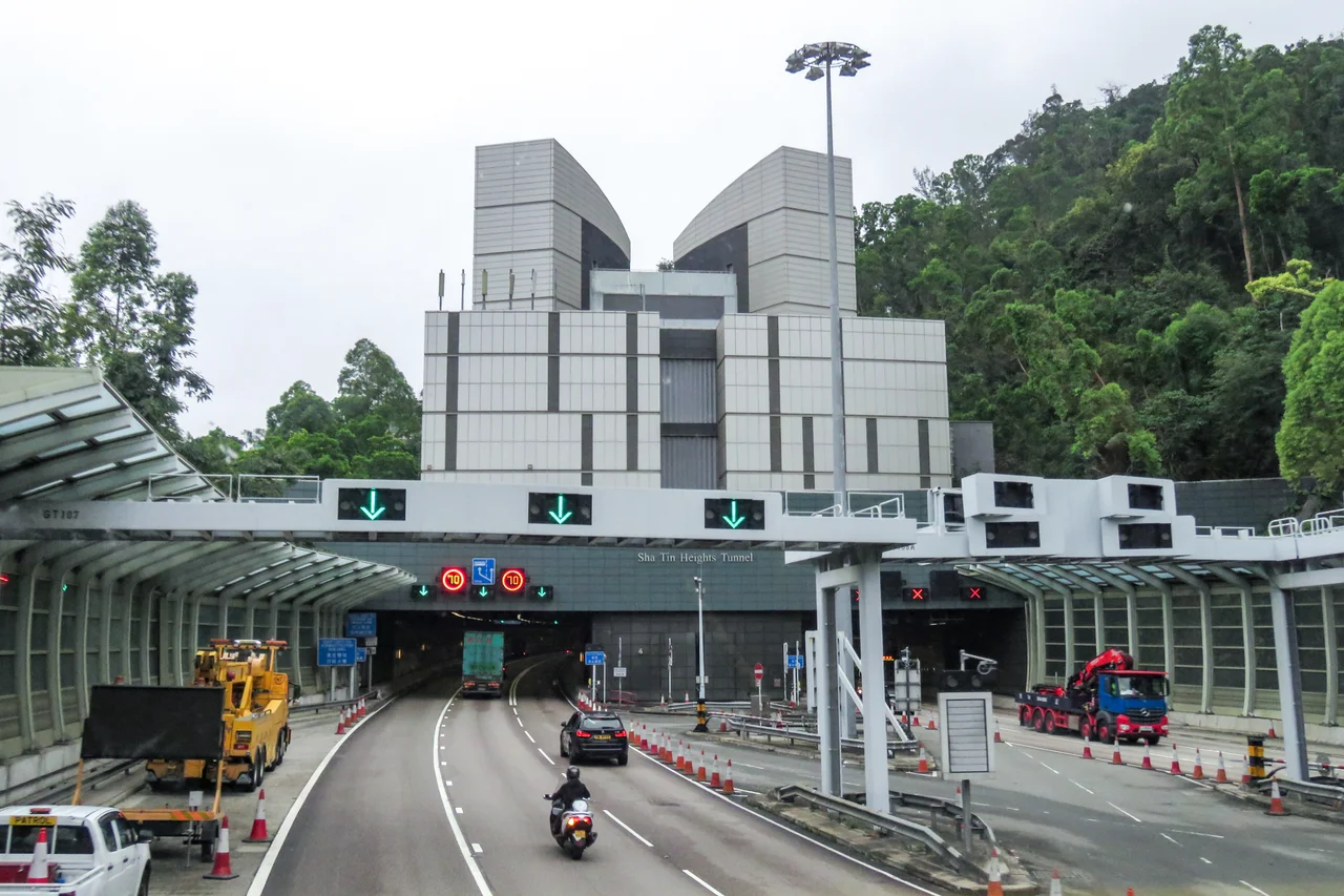
Tai Wai is the main gateway for traffic between the New Territories and Kowloon, a role encoded in three tunnels: the Lion Rock Tunnel (1967, Hong Kong's first road tunnel), the Shing Mun Tunnels (1990), and the Sha Tin Heights Tunnel (2008). Tai Po Road, which preceded them all, remains the only toll-free road connection between the areas. The MTR Tai Wai station now serves as an interchange between the East Rail line and the Tuen Ma line; nearby Hin Keng station, which opened in February 2020, completed the Sha Tin to Central Link. For cyclists, the river bike path runs along the Shing Mun River all the way to Tai Po, Ma On Shan, and Plover Cove Reservoir — a quieter crossing than any of the tunnels. The chicken congee and roast pigeon that Tai Wai restaurants are known for reward the journey either way.
From the Air
Tai Wai sits at approximately 22.383°N, 114.183°E at the southwestern end of the Sha Tin Valley. From the air, the area is framed on the south by the sharp ridge of Lion Rock (495 m) and on the west by the Shing Mun hills. The elevated viaducts of the MTR Tuen Ma line trace visible arcs across the district. The Shing Mun River is a useful orientation landmark, running northeast through the valley toward Tolo Harbour. Hong Kong International Airport (VHHH) lies approximately 30 km to the west-southwest on Lantau Island. Kai Tak (VHHX) is the former airport site to the south. Recommended viewing altitude: 3,000–4,000 feet to capture the full valley geography with Lion Rock prominent.
Nearby Stories
- Chapel of St. Francis Xavier 3.5 km away
- Cuiheng 4.1 km away
- 2015 Shenzhen Landslide 16 km away
- Shunde 31 km away
- Wanshan Archipelago 37 km away
- Nanxiong Formation 96 km away
- Heyuan 149 km away
- Checheng Fu'an Temple 629 km away