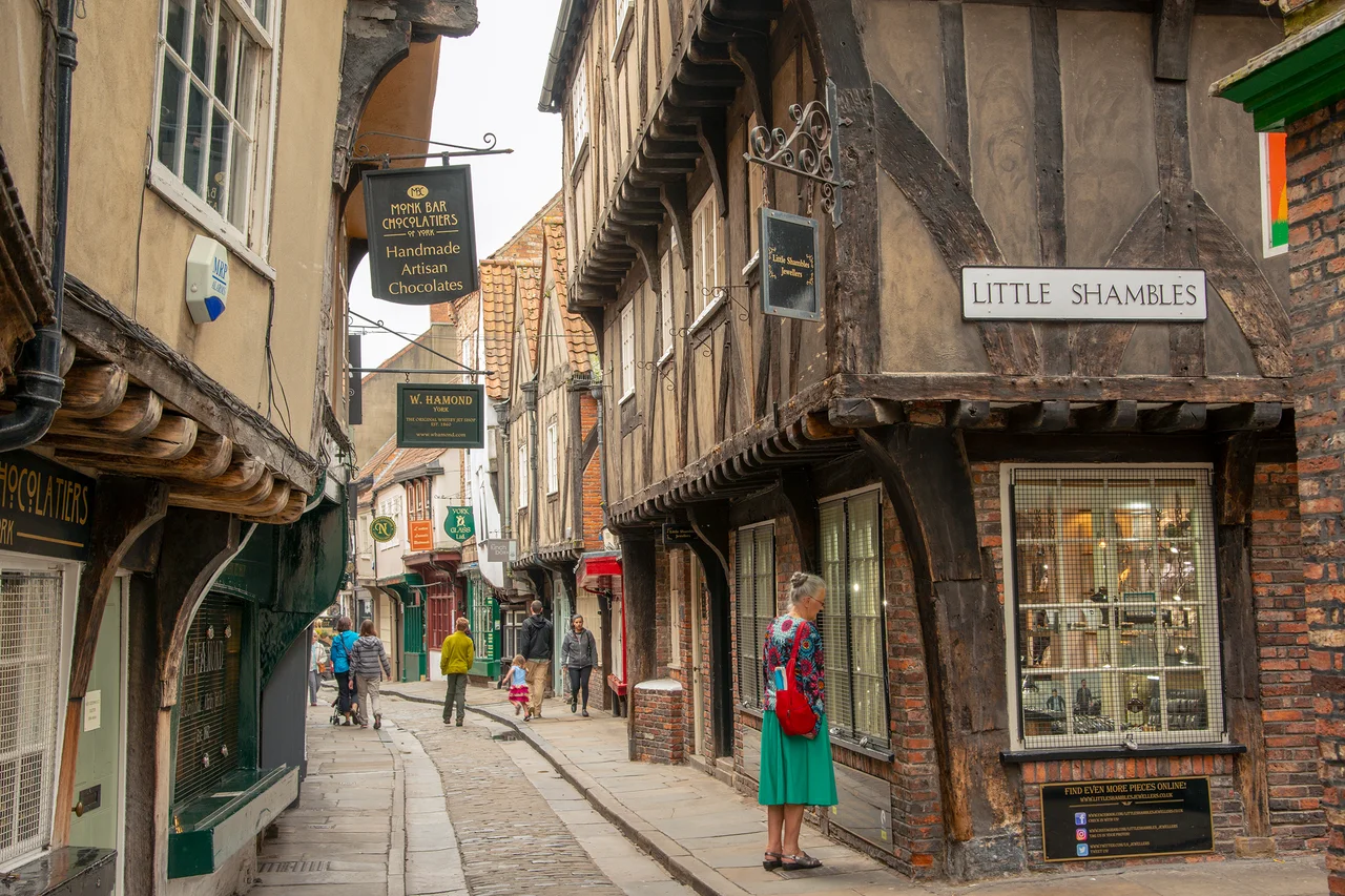

The Shambles
Stand on the pavement of The Shambles and you can almost touch the buildings on both sides at once. The upper floors lean further out than the lower ones - a medieval architectural trick called jettying - until the eaves nearly meet above your head. In 1885, thirty-one butchers worked along this single street, hanging meat from hooks on the outer walls of shops that had been doing the same thing for at least four hundred years. None of them is still here. The hooks are.
The Word Means Bench
Despite the modern English meaning of 'shambles' - a scene of chaos and ruin - the word started life as something much smaller and tidier. From Old English sċeamol, via Middle English schamel, it originally meant a bench or stall. By AD 971 it referred to a 'bench for the sale of goods.' Only by the early 14th century had it become associated specifically with meat-selling. The street itself had several names before settling. By 1240 it was Haymongergate. In 1394 it was Nedlergate. By 1426, the butchers had won the naming contest and it had become the Great Flesh Shambles, eventually shortened to the name on the street sign today. The word 'shambles' came to mean a slaughterhouse, and then a mess - the chaos of an animal slaughterhouse - and then any kind of mess. The street was the source word.
Older Than the Domesday Book
The Shambles is not explicitly named in the Domesday Book of 1086, but historians have identified it through an entry recording two butchers' stalls near the church of St Crux, held by the Count of Mortain (William the Conqueror's half-brother). The street's character was already set: narrow, mercantile, blood-stained. The timber-framed buildings you see today are mostly 14th and 15th century. Number 1 Shambles is probably 14th century. Numbers 7-8 are late and early 15th century. Number 9 is 15th century. Numbers 10-11 began as a single 15th-century house, divided later. Almost every building on the street is now listed. What was demolished, in a tidying-up campaign of the 1950s, were the slaughterhouses and outbuildings behind the shops - the working back rooms where animals were killed and butchered. Modern conservators consider those demolitions a mistake.
The Pearl of York
Halfway down The Shambles is a tiny shrine, easy to miss. It marks the home of Margaret Clitherow, a butcher's wife who lived here in the 1570s and 1580s. She had converted to Catholicism in a Protestant England, and she hid Catholic priests in her house and held secret masses. Caught in 1586, she refused to plead at her trial, which by law meant she could be subjected to peine forte et dure - pressing to death under heavy weights to force a plea. She accepted death rather than allow her children to be made to testify against her. She was killed on 25 March 1586, aged about 33. Pope Paul VI canonised her in 1970. The Catholic Church calls her the Pearl of York. The shrine in her old home is small - a candle, an image, an explanation - and most of the tourists walking past it have no idea what they are looking at.
Diagon Alley It Isn't
Since 2017, The Shambles has acquired four wizard-themed shops selling wands, robes, and Hogwarts merchandise. The street is one of several around the British Isles - along with locations in Chepstow, Edinburgh, Exeter, and London - claimed as the inspiration for Diagon Alley in the Harry Potter books. J.K. Rowling has flatly denied this, stating she had never been to The Shambles before writing the novels. Locals are divided. Some welcome the tourism. Others find the shops a tacky overlay on what was already one of the best-preserved medieval streets in Europe, attracting visitors for centuries before anyone wrote about wizards. What can be said with certainty: the street looks like what people who have never seen a medieval city think medieval cities looked like, which is almost the same thing as saying it looks the way medieval cities actually did.
Snickelways
Five small alleyways - called snickelways in York's particular vocabulary - lead off The Shambles. They were originally service routes to the rear of the butcher shops, the working alleys where carts came and went. After the 1950s demolitions cleared the back buildings, these alleys now open into the broad expanse of Shambles Market (renamed in 2015 from Newgate Market). Slip into one of them and you go from a tight medieval street into a 21st-century market in about ten paces, then back again. York is full of these compressions of time - it is one of the city's defining qualities, the way its centuries are stacked against each other at touching distance.
From the Air
The Shambles runs through the medieval centre of York at 53.959°N, 1.080°W, just south of York Minster and east of the River Ouse. From the air the street is too narrow to see directly, but it sits inside the unmistakable medieval city centre - look for the cathedral, the encircling walls, and the cluster of red-tiled roofs between them. Leeds Bradford (EGNM) is about 22 nm southwest. The whole of York's walled core fits inside a circle barely a mile across.
Nearby Stories
- Scampston Hall 3.5 km away
- Salts Mill 4.7 km away
- Newburgh Priory 6 km away
- Brodsworth Hall 6.2 km away
- Coverham Abbey 16 km away
- RAF Leconfield 17 km away
- Macclesfield Canal 27 km away
- RAF Scampton 35 km away