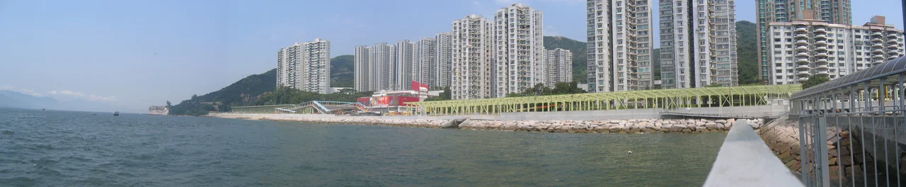

Tsing Lung Tau
Dragon Beach is gone. The strip of shoreline that gave Tsing Lung Tau one of its most evocative features — a stretch of sand called Dragon Beach, 青龍灣, named for the headland's shape — was reclaimed by the Hong Kong government in 2006 to widen Castle Peak Road. The beach exists now only in photographs and in the memories of people old enough to have swum there. What remains is the headland itself, caught between Sham Tseng to the east and Tai Lam to the west, looking out across the Pearl River estuary toward the mainland.
The Headland Between Towns
Tsing Lung Tau occupies a particular kind of in-between position. It sits on the southwest coast of the New Territories, west of Tsuen Wan and east of Tuen Mun — not quite belonging to either, linked to both by the single artery of Castle Peak Road. The name translates roughly as 'Green Dragon Head,' a reference to the promontory's outline when seen from the water. For much of Hong Kong's modern history, this geography made Tsing Lung Tau something of a backwater in the best sense: accessible but not central, residential without being intensely urban. Farmland once ran alongside the beach. Fishing boats came and went from the pier. The ferry that once connected the village to Yam O across the water has long since stopped running, its route made redundant by road improvements.
A Temple Older Than the Colony's Records
At Nos. 56–58 Castle Peak Road stands a Tin Hau Temple documented as having been built before 1889. The temple's age is notable because 1889 is itself an early date in the colonial administrative record — the New Territories were not formally leased to Britain until 1898, and even the earliest colonial surveys of the region are incomplete. That this temple predates those surveys suggests a community with established religious practice, one that had been worshipping Tin Hau — the Empress of Heaven, protector of those who live and work by the sea — for generations before anyone thought to write it down. The sea was close. Castle Peak Road now runs between the temple and the water, but the connection to the maritime world that gave Tin Hau her significance is built into the location's history.
Villas and Villages Together
Modern Tsing Lung Tau is a layered place. Three villages — Tsing Lung Tau Village, Tsing Lung Tau New Village, and Yuen Tun Village — carry the older settlement patterns. Around them, and increasingly dominant in terms of built area, are villa-style private housing estates that arrived from the 1980s onward. Hong Kong Garden, a large development with 28 blocks, was completed in phases between 1986 and 2010. Lung Tang Court, completed in 1982, was an earlier wave of the same impulse: middle-class families seeking space and coastline views within reasonable commuting distance of urban Kowloon. Sea Crest Villa Phase 5 followed. The result is a community that holds both the village committee of a recognised New Territories settlement and the amenities — and density — of a modern suburban estate.
Connected by One Road
Castle Peak Road is the spine of everything here. It is the only major artery into and out of Tsing Lung Tau, carrying buses toward Tuen Mun in one direction and toward Tsuen Wan in the other. Minibuses take the same route. The Airport Express at Tsing Yi station, about eight kilometres away, connects the area to Hong Kong International Airport (VHHH). The Tsing Lung Tau Ferry Pier, where the junction of Lung Yue Road meets Castle Peak Road, is still marked on maps, though the ferry service to Yam O it once served has been suspended. The pier's presence is a reminder of an era when water transport was as practical as road transport for reaching remote corners of the New Territories.
The Dragon Garden Above the Shore
Among the built heritage of Tsing Lung Tau, the Hong Kong Dragon Garden deserves particular mention. Situated along Castle Peak Road, it is a private garden of considerable ornamental ambition, created in the latter half of the twentieth century as an expression of Chinese garden aesthetics adapted to the Hong Kong landscape. Large sculpted dragons — the headland's namesake creatures — are among its features. The garden is not a public park and its accessibility has varied over the years, but its existence alongside the temple and the village committee office creates a small district of inherited or constructed culture in an area that might otherwise read as pure residential development. The dragon, for Tsing Lung Tau, is both name and recurring motif.
From the Air
Tsing Lung Tau is located at approximately 22.36°N, 114.05°E on the southwest coast of the New Territories, where the shoreline bends around a small promontory between Sham Tseng and Tai Lam. From the air, the headland is identifiable by its curved coastline and the concentration of mid-rise residential buildings along Castle Peak Road. The Pearl River estuary opens to the southwest, with views toward the Guangdong coast in clear weather. Castle Peak (583 m) rises prominently to the northwest. Hong Kong International Airport (VHHH) on Lantau Island lies approximately 12 km to the south. Recommended viewing altitude is 1,500–3,000 feet. The former location of Dragon Beach can be traced along the shore where reclamation has straightened the coastline beside the road.
Nearby Stories
- Chapel of St. Francis Xavier 3.5 km away
- Cuiheng 4.1 km away
- 2015 Shenzhen Landslide 16 km away
- Shunde 31 km away
- Wanshan Archipelago 37 km away
- Nanxiong Formation 96 km away
- Heyuan 149 km away
- Checheng Fu'an Temple 629 km away