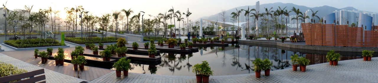

Tsing Yi Northeast Park
Before there was a park here, there was a fight. On one side: the shipyard owners and workers who had operated along this stretch of Tsing Yi Island's north shore since 1964, arriving after they were pushed out of Cheung Sha Wan on the Kowloon mainland to make way for urban development. On the other: the families who moved into the new housing estates of Ching Tai Court and Cheung On Estate in the late 1980s, only to find that their windows faced directly onto working shipyards — the grinding and clanging of heavy industrial work running from dawn into the evening. By 1996, the Hong Kong Government had decided someone had to move. The shipyard owners and workers protested, arguing that relocation would harm their livelihoods. Demolition began on 2 November 1999. The last yard was cleared by June 2000. What came next took another decade: contamination surveys, decontamination works, reclamation of foreshore and seabed, a 520-metre seawall, and finally Tsing Yi Northeast Park, which opened on 28 May 2010.
Estuary to Shipyard to Green Space
A 1928 War Office map shows what this site looked like before any of this: a small estuary, fed by a stream, with stones and boulders where the water met the shore. That natural landscape lasted until the 1960s, when the reclamation of Cheung Sha Wan in western Kowloon forced shipyards to relocate to less contested ground. The isolated north shore of Tsing Yi, stretching from the hamlet of Cheung Shue Tau to the peninsula of Tam Kon Shan, offered exactly that. By 1963 the shore was prepared; by 1964 the shipyards had moved in, building factories and slipways over the following years. At that time there was no mains power supply on this part of the island. Workers reached the site by walla-walla water taxi to Tsuen Wan or by walking the hills over Tam Kon Shan to reach the ferry pier. For nearly two decades, the shipyard area existed largely separate from the rest of the island, a small industrial world at the end of difficult roads.
When the Neighbours Arrived
The tension that eventually produced this park began in 1983, when a new wave of housing development swept through the northeast part of the island. The hill of Tam Kon Shan was levelled. The Mun Tsai Tong typhoon shelter was reclaimed. High-rise housing estates — Cheung On Estate, Cheung Fat Estate, Ching Tai Court — rose from the reclaimed ground, and a new road, Tam Kon Shan Road, connected the residential area to the shipyard zone. By 1988, when the first residents moved in, three blocks of flats and a secondary school were looking directly across at active shipyards. The noise was not occasional. It was the constant, heavy sound of industrial work, day after day, filling homes and classrooms that had been built without any buffer between them and the machinery. A 2001 Legislative Council document cited the noise nuisance as the primary reason for the eventual park project.
The Difficult Ground Beneath
When the shipyards were finally gone, the land they left behind was not clean. Before reclamation could begin, there were serious concerns about soil contamination from decades of shipyard operations — particularly regarding dioxins, a problem similar to what was encountered at Penny Bay during the construction of Hong Kong Disneyland. The site required decontamination before any public use could be considered. The project that followed was substantial: reclamation of approximately 3.8 hectares of foreshore and seabed, site formation of around 3.2 hectares of existing land, construction of a 520-metre seawall, and extensive drainage works. The total capacity of the public filling area created by the reclamation was 500,000 cubic metres. Tsing Yi at the time required 12 hectares of open space to address a serious shortage. The new park contributed to closing that gap, while the reclaimed land also served as a buffer between the remaining industrial zone to the west and the residential neighbourhoods to the east.
The Park Today
Tsing Yi Northeast Park occupies 5.8 hectares along the north shore, bordered by Rambler Channel to the north, Ching Tai Court to the east, Tam Kon Shan Road to the south, and a buffer zone adjacent to the remaining shoreline shipyards to the west. From the park, the channel opens out toward Tsuen Wan on the opposite shore, with container traffic moving in the distance. The view is industrial and urban and, in its own way, dramatic — a working waterway rather than a scenic coastline, but one that carries a palpable sense of the economic activity that has defined this corner of Hong Kong for generations. Access is straightforward: visitors can walk from Cheung On Bus Terminus in a few minutes, with green minibus route 88A also serving Tam Kon Shan Road. The park opened in 2010, fifteen years after the conflict that began its story.
From the Air
Tsing Yi Northeast Park lies at approximately 22.362°N, 114.099°E on the north shore of Tsing Yi Island, facing Rambler Channel. From the air at 1,500 feet, the park appears as a green strip between the waterfront and the high-rise estates of Ching Tai Court and Cheung On Estate. The Rambler Channel runs north of the park, with Tsuen Wan visible on the far shore. Hong Kong International Airport (VHHH) is approximately 9 nautical miles to the southwest. The Tsing Ma Bridge is visible to the southwest. The island's industrial southwest — oil depots and container terminals — contrasts sharply with the residential northeast visible from this altitude.
Nearby Stories
- Chapel of St. Francis Xavier 3.5 km away
- Cuiheng 4.1 km away
- 2015 Shenzhen Landslide 16 km away
- Shunde 31 km away
- Wanshan Archipelago 37 km away
- Nanxiong Formation 96 km away
- Heyuan 149 km away
- Checheng Fu'an Temple 629 km away