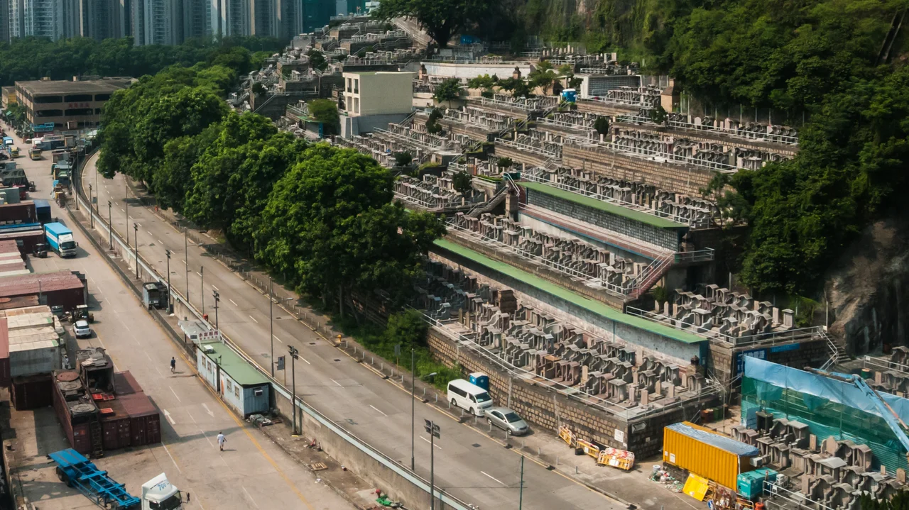

Tsuen Wan Chinese Permanent Cemetery
The word 'Permanent' in the cemetery's name refers to the land, not the graves. It is a legal and administrative distinction — the site is permanently designated for burial use, as distinct from temporary burial grounds — but it carries an inadvertent weight. On a slope between Riviera Gardens and the Tsuen Wan Abattoir, facing Gin Drinkers Bay and the Rambler Channel, the land has held the dead of Hong Kong since 19 June 1941, when the cemetery opened just months before the Japanese invasion. The Hong Kong Government had approved the land three years earlier, on 9 August 1935: approximately 120,000 square metres on a hillside in what was then Tsuen Wan, though the boundary between Tsuen Wan District and Kwai Tsing District runs along Texaco Road and Tsing Tsuen Bridge nearby, placing the cemetery technically within Kwai Tsing District. The Board of Management of the Chinese Permanent Cemeteries, which oversees all four of Hong Kong's Chinese permanent cemetery sites, has administered it ever since.
A Hillside Opened in Wartime
The timing of the opening — June 1941 — meant that the cemetery received its first burials in the same year Hong Kong entered the most violent period in its modern history. The Battle of Hong Kong in December 1941 killed thousands, and the three years and eight months of Japanese occupation that followed brought hardship, displacement, and death across the colony. Whether and how that history touched this particular hillside is not recorded in the sparse official account, but it is worth holding in mind: this was a place of burial established on the eve of catastrophe, and the families who brought their dead here in those early years did so in circumstances that were anything but ordinary. The cemetery is the second Chinese permanent cemetery in Hong Kong, following Aberdeen Chinese Permanent Cemetery, and was intended from the beginning to serve the growing Chinese population of the Tsuen Wan and Kwai Chung areas.
The View from the Slope
The cemetery looks out over Gin Drinkers Bay — named on historical British maps, a corner of the western approaches to Victoria Harbour where the water narrows between Tsing Yi Island and the mainland. Rambler Channel runs beyond, connecting to the busy waterway that carries container traffic in and out of the Kwai Tsing port. From the slopes on a clear day, the scene is layered: water in the middle distance, the industrial shoreline of Tsing Yi beyond, and the green ridge of Tsing Yi Peak rising above it all. It is, despite everything built around it, a considered place to be buried — elevated, facing water, with the hills visible on the far shore. Traditional Chinese beliefs about the orientation of burial sites, and the importance of facing water and open ground, were very much part of how these hillside cemeteries came to occupy the positions they do throughout Hong Kong.
The People Buried Here
Among those interred in the cemetery are figures who shaped Hong Kong and the wider region in ways still visible today. Eu Tong Sen (1877–1941), who built one of the largest business empires in colonial Malaya and Singapore before his wealth and influence extended to Hong Kong, is buried here. So is Admiral Chan Chak (1894–1949), who in December 1941 led a famous escape from besieged Hong Kong by torpedo boat, bringing British officers and Chinese personnel to safety through Japanese-controlled waters. Tam Woon-tong (1872–1954), a former chairman of Po Leung Kuk — the charity founded to protect women and children from trafficking — and a co-founder of Kowloon Motor Bus, helped bring public transport to the New Territories. Chan Nam Cheong (1900–1971) co-founded Vitasoy, the soy milk brand that became an institution in Hong Kong kitchens. Tang Ti-sheng (1917–1959) wrote for Cantonese opera and film. These were not peripheral lives; they were central to the city's commercial, cultural, and social history.
Columns and Niches
The cemetery has adapted to the changing practices of Hong Kong's Chinese communities over the decades since it opened. As cremation has become increasingly common — driven partly by the scarcity of land in one of the world's most densely populated cities — the cemetery developed columbariums to hold cremation niches. The first two were completed in 1974 and 1987. Demand continued to grow, and the first columbarium was expanded in 2015, providing additional niches to meet the rising preference for cremation over ground burial. This shift is a significant one in a culture where the treatment of the dead has historically been governed by specific ritual requirements, including the expectation of intact burial. The practical pressures of Hong Kong's land constraints have gradually reshaped those practices, and the cemetery's architecture reflects that transformation — older grave terraces on the slopes, newer columbarium buildings on the same hillside, serving the same families across different generations.
From the Air
The Tsuen Wan Chinese Permanent Cemetery lies at approximately 22.359°N, 114.116°E on slopes above the southern shore of Gin Drinkers Bay, facing Rambler Channel and Tsing Yi Island. From the air at 1,500–2,000 feet, the cemetery is visible as a terraced hillside above the waterfront between Riviera Gardens and the Kwai Chung shoreline. Tsing Yi Island, with its distinctive green ridge of Tsing Yi Peak, lies directly across the channel to the west-southwest. Hong Kong International Airport (VHHH) at Chek Lap Kok is approximately 10 nautical miles to the southwest. The Tsing Yi North Bridge (Tsing Tsuen Bridge) passes nearby to the west.
Nearby Stories
- Chapel of St. Francis Xavier 3.5 km away
- Cuiheng 4.1 km away
- 2015 Shenzhen Landslide 16 km away
- Shunde 31 km away
- Wanshan Archipelago 37 km away
- Nanxiong Formation 96 km away
- Heyuan 149 km away
- Checheng Fu'an Temple 629 km away