Wangerooge Island Railway
If you arrive on Wangerooge by ferry, the train is waiting at the end of the pier. There is no other option. There are no taxis lined up, no buses idling, no rideshare app that will get you to your hotel. The island has no road connection to the mainland. The ferry comes when the tide allows it. And from the moment you step off the gangway with your suitcase, the only practical way to cross the four kilometres of salt marsh and dune that separate the pier from the village is a small blue-and-white narrow-gauge train that has been making the same run, more or less, since 1897.
An Island That Chose Steam
Wangerooge is the easternmost of the East Frisian Islands, a thin barrier of sand and dune wedged between the open North Sea and the Wadden Sea tidal flats. In 1897 the Grand Duchy of Oldenburg State Railways opened a single-track metre-gauge railway from the newly built southwest pier to the Inseldorf - the island village - in the centre of the island. Most neighbouring islands operated horsecars at the time. Wangerooge skipped that step entirely and ran steam locomotives from day one. The original journey took about twenty minutes for the 3.5-kilometre line at a top speed of 30 km/h. More than a century later, those timings are essentially unchanged - though today's diesel-hauled trains crawl along at 20 km/h on rebuilt ballasted track.
Two World Wars, Many Branches
The railway's network ballooned and contracted with the island's military importance. In 1905 a second pier, the East Pier, was added with its own 5.4-kilometre line. In 1912 a new West Pier replaced the original one. During the First World War the island was fortified as a coastal defence position, and the railway sprouted branch lines to artillery batteries and command posts - four sections of track with as many as 24 spurs feeding military installations on a sliver of land less than ten kilometres long. In the Second World War the island took on similar strategic importance because of its proximity to the Weser estuary and Wilhelmshaven. On 25 April 1945, weeks before the war ended in Europe, an Allied air raid hammered Wangerooge, destroyed the line between Saline and the village, demolished the station hall, and burned dozens of passenger coaches and wagons.
From Steam to Diesel
After the war the line was rebuilt. In 1952 the Deutsche Bundesbahn took over operations and began phasing out the steam engines, starting with a Gmeinder diesel locomotive. By 1957 the transition was complete. The same year that diesel power arrived, the British finally returned the nearby island of Heligoland to German civilian control - and the heavy summer ferry traffic that had been routing through Wangerooge's East Pier collapsed almost overnight. The East Pier and its branch line were dismantled in 1958. About 200 metres of those old eastern tracks survive today as sidings, the last fossil of a network that once handled more than two-thirds of the island's arriving holidaymakers.
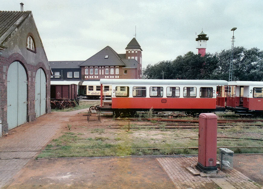
The Last DB Narrow-Gauge
The Wangerooge Island Railway is the only narrow-gauge railway still operated by Deutsche Bahn. Since 2002 it has fallen under the DB AutoZug business unit. Two newer Schoema diesel locomotives delivered in 1999 - numbers 399 107 and 108 - haul most passenger trains. Fourteen light-blue-and-white passenger coaches, repainted in the late 1990s in a livery reminiscent of Interregio express trains, have replaced the dark green stock of the 1960s. About 200,000 visitors use the railway every year, and on peak summer days 1,500 passengers travel each way. There is no other transport on the island worth the name. Cars are prohibited. Bicycles work for getting around the village but not for shifting luggage and groceries from a ferry pier four kilometres out across the dunes.
Tides, Salt, and Birds
The ferry from Harlesiel on the mainland cannot run on a fixed timetable, because the channel through the mud flats is only deep enough at certain tides. So the train schedule is published in advance for the whole season, locked to the moon and the daily rhythm of the Wadden Sea. The line itself crosses salt-tolerant vegetation that floods at high water, and the stretch between the West Pier and the Saline junction runs straight through a breeding area for sea birds that have, over generations, simply learned to ignore the trains rumbling past their nests. From the youth hostel at the Westturm you can watch two trains crossing each other in front of the pier, the entire system on display in miniature. Goods wagons trail every passenger train, hauling the suitcases handed in at the ferry, the groceries, the furniture, the bicycles. It is how an island lives without roads.
From the Air
Coordinates: 53.79 N, 7.88 E. From altitude Wangerooge appears as a thin east-west sliver of dune and beach in the East Frisian chain, with the ferry channel through the Wadden Sea visible to the south and open North Sea to the north. The railway runs roughly east-west along the southern side of the island between the West Pier and the village. Recommended viewing altitude 2,000 to 4,000 feet for the full line. Nearest airports: Wangerooge has a small airfield (EDWG) on the island itself; mainland alternatives include Bremerhaven (EDWB) and JadeWeserAirport (EDWI). Best aerial views at low tide when the surrounding mud flats are exposed.
Nearby Stories
- SM UC-71 3 km away
- Jever Brewery 4.2 km away
- Berum Castle 5.8 km away
- Baltrum 17 km away
- SMS Ariadne 17 km away
- Wöbbelin Concentration Camp 204 km away
- Ludwigslust Palace 210 km away
- Lilleø 214 km away