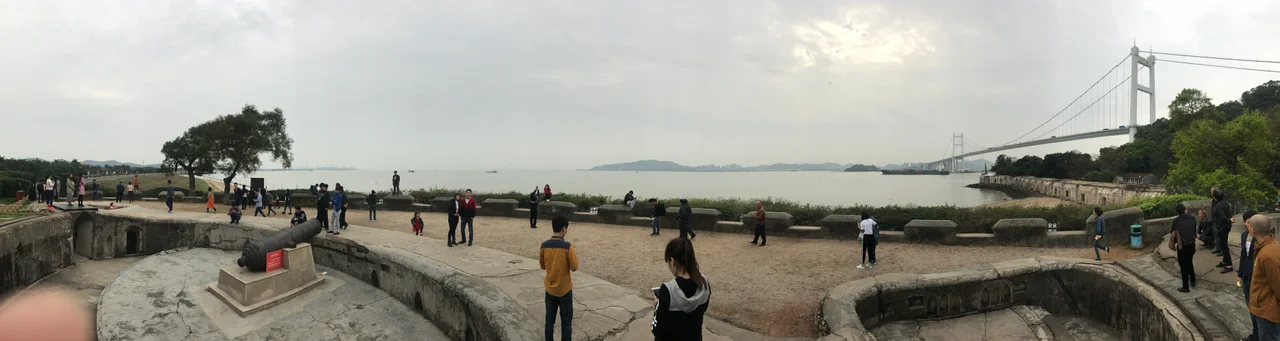

Weiyuan Fort
The Humen Strait is the throat of the Pearl River Delta — the single navigable passage through which all ships bound for Canton once had to pass. The Qing dynasty understood this perfectly. By the 1830s, the empire had lined the strait's banks with fortifications, and in 1835, at the suggestion of official Lu Kun, workers completed the last and most unusual of them: Weiyuan Fort, a 360-meter crescent of stone built in the style of a crossed platform, its 44 cannons aimed at the water below. Today the fort is a ruin, shaded by trees, sitting directly beneath the shadow of the Humen Bridge. But the stones remember what passed here.
A Fortress Designed by Committee
Weiyuan Fort did not emerge from a single strategic vision. It was the final piece in a system. Plans were drawn up in 1834 after the Qing government decided the existing defenses of the Humen Strait were insufficient. Four major forts had already been built along the strait's approaches. Lu Kun argued that a fifth was needed, one with an unusual crossed-platform design that would provide overlapping fields of fire. Simultaneously, Yong'an Fort was constructed on the western end of a nearby island, and Gonggu Fort rose on the opposite bank in the foothills of Luwan Mountain. Together, these fortifications were meant to form an interlocking defensive network. The construction of Weiyuan Fort was completed in 1835. It held 40 concealed artillery positions and four open gun platforms, armed with cannons meant to sink or drive off any vessel attempting to force the passage.
Three Times Taken
Weiyuan Fort was captured not once but three times in the span of fifteen years — a measure of how fundamentally the world had changed around it. In the 1841 Battle of the Bogue, British forces overwhelmed the strait's defenses during the First Opium War, taking the fort along with the others. Six years later, during the 1847 Expedition to Canton, British forces passed through again. Then, in 1856, a second Battle of the Bogue unfolded as the Second Opium War brought renewed fighting to the same waters. The fort's cannons, fixed in their stone emplacements, could not swivel quickly enough to track the steam-powered warships that the industrial age had produced. What had been state-of-the-art coastal defense in 1835 was obsolete within a decade.
After the Wars
The Opium Wars eventually ended, the Qing dynasty eventually fell, and the Humen Strait passed into a new era. During Sun Yat-sen's Constitutional Protection Military Government period in Guangzhou, the fort and the broader Humen Fortress complex continued to hold strategic significance. Gong Zhenzhou served as commander-in-chief of the Humen Fortress during that period, a reminder that the strait remained militarily important long after the specific battles of the 1840s and 1850s had passed. The site also carries personal historical associations: photographs from the early Republican era show Soong Ching-ling, the widow of Sun Yat-sen, visiting Weiyuan Fort — a gesture acknowledging the site's place in China's modern historical memory.
The Fort Beneath the Bridge
Standing at Weiyuan Fort today, the most striking fact is what towers over it. The Humen Bridge, completed in 1997, crosses the strait directly above the fortification. The contrast is almost too neat: one of China's great modern engineering achievements spans the same chokepoint that Qing engineers once labored to defend with stone and iron. The fort itself is 360 meters in length, and admission is free with valid documents. The curved walls, the alcoves where cannons once rested, the views across the water that Qing artillerymen once scanned — these remain accessible to anyone who makes the journey to Dongguan city. The Pearl River Delta that surrounds the fort is now among the most industrialized regions on Earth. The ruined fort, quiet in the shadow of the bridge, is one of the few places where what that transformation cost can still be felt.
From the Air
Weiyuan Fort sits at 22.798°N, 113.621°E on the western bank of the Humen Strait in Dongguan, Guangdong. At 2,000 feet, the Humen Bridge is the dominant visual landmark — its twin suspension towers are clearly visible, and the fort's curved stone structure lies directly beneath its southern anchorage. The Pearl River Delta's branching channels spread northward toward Guangzhou. Nearest major airport: ZGGG (Guangzhou Baiyun International Airport), approximately 65 km to the northwest. The low terrain of the delta offers wide visibility in clear conditions; the strait itself is easy to identify as the primary navigable channel between the islands.
Nearby Stories
- South China Mall 1.5 km away
- Sham Chung 7.1 km away
- Fengjian Village 7.4 km away
- Foshan Wong Fei-hung Memorial Hall 9 km away
- Nei Lingding Island 12 km away
- West Lake (Huizhou) 16 km away
- Horizontal Skyscraper – Vanke Center 19 km away
- Yamen, Guangdong 27 km away