Westerbork
Say the word "Westerbork" to anyone Dutch and watch their face change. The village itself is small, ordinary, even pleasant - 4,700 people going about their lives among the heaths and forests of Drenthe. But the name belongs to something else now, something that happened ten kilometers to the north, in a clearing in the woods near the village of Hooghalen. The geography is almost cruel in its tidiness: the camp wasn't even technically in Westerbork. Yet the name attached itself anyway, the way grief attaches to a place that didn't ask for it, and refuses to let go.
The Village That Carries a Name
Westerbork the village predates Westerbork the wound by centuries. Brick farmhouses line streets that converge on the B.G. van Weezelplein. There's a Hoofdstraat with a bakery, a couple of cafes, the kind of unremarkable shops that keep a small Dutch town running. Children bike to school. Old men nurse coffee. The place breathes the slow rhythm of rural Drenthe, a province where the loudest sound on most afternoons is wind moving through pine. The villagers know what their name has come to mean. They live with it the way people live with weather they cannot change - acknowledging it, but not letting it run their days.
Beyond the Camp
Most visitors come for the memorial site, but the country around Westerbork rewards anyone who lingers. The Drents-Friese Wold National Park stretches west into mixed forest and shifting heath. To the south lie the prehistoric hunebedden of Borger - megalithic dolmens built by Funnelbeaker people more than five thousand years ago, when this corner of Europe was first being shaped by human hands. Bike paths thread the whole region, signed for cyclists rather than drivers, and one of them traces a Anne Frank route that loops 44 or 53 kilometers through the landscape she briefly passed through on her way east.
Ears to the Universe
There is another reason you cannot drive directly to the former camp site, and it has nothing to do with reverence. Just beside the memorial sprawls the Westerbork Synthesis Radio Telescope - fourteen dish antennas standing in a long row across a field of grass, listening for radio waves from the edge of the observable universe. The array has been one of Europe's most important radio observatories since 1970. Cars throw off electromagnetic noise that would interfere with the instruments, so visitors must park at the museum and walk the educational path through the trees. The juxtaposition is jarring at first: a place of profound human darkness sitting next to instruments straining to hear the faintest whispers of cosmic time. After a while it begins to feel right.
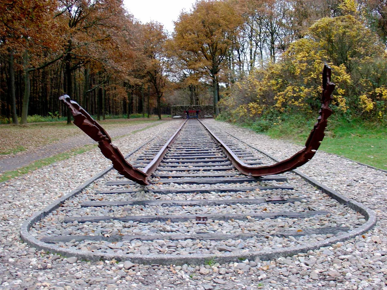
The Path Through the Trees
From the parking lot at the Herinneringscentrum, the walk to the actual camp ground is 2.7 kilometers along a path that doubles as a slow education. Signs along the way tell pieces of the story - who came through here, what they faced, what was lost. Wheelchairs are available for those who need them. When the visitor center is open, small buses also make the run for a euro and a half. You can bike it on your own wheels but no rentals are offered, a small reminder that this is not quite an attraction. By the time you reach the site, you have already spent half an hour with the weight of what is coming, and the silence at the destination feels less like absence than arrival.
Living With Memory
Westerbork has chosen neither to hide its history nor to drown in it. The village hosts hikers and cyclists, runs a tourist office, recommends day trips to Bourtange's star fort and the zoo at Emmen. It does what small Dutch towns do: it gets on. But it also knows that thousands of people pull off the A28 every year specifically because of a name, and it has built that knowing into how it welcomes them. The camp museum and the village exist in a quiet pact - one to remember, one to live - and somewhere in the space between them, a kind of grace holds the whole arrangement together.
From the Air
Westerbork village lies at 52.85 N, 6.61 E in the province of Drenthe, northeastern Netherlands. Cruise low over the rolling heaths and pine forests of Midden-Drenthe at 1,500-3,000 feet for the clearest view; the village itself is a tight cluster of red-tile roofs around a central square. Look north toward Hooghalen to spot the distinctive long row of the Westerbork Synthesis Radio Telescope's dish antennas - they make the former camp site easy to locate from the air. Nearest controlled airspace: Groningen Airport Eelde (EHGG) about 30 km north. Class G uncontrolled airspace dominates the area; visibility is usually good outside winter fog season.
Nearby Stories
- Kampen, Overijssel 3.9 km away
- Weerribben-Wieden National Park 5.4 km away
- Groningen Airport Eelde 6.3 km away
- Winschoten 7.1 km away
- Wietmarschen 7.4 km away
- Ommen 7.5 km away
- Sellingerbeetse 13 km away
- Wytgaard 14 km away