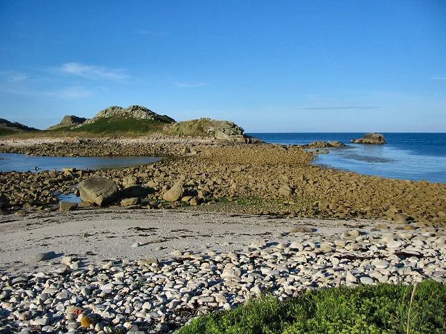

White Island, Isles of Scilly
Twice a day, an island appears. For a few hours on either side of low water, a rough causeway of shingle and boulders surfaces between St Martin's and White Island, and you can walk across. Then the Atlantic reclaims it. The currents that pour across the bar at the turn of the tide are strong enough to drown experienced swimmers, and the granite slabs underfoot are slick with kelp. White Island sits at the northern edge of the Isles of Scilly, exposed to every gale that crosses three thousand miles of ocean. Bronze Age people buried their dead here. Modern biologists count gull chicks. In Cornish, the older name was Enys Wynn, the white island, and the Cornish word for that south-eastern cove, Camper, means tide race. Everything here is named for the sea.
The Island That Wasn't
Geologists know White Island as a recent departure. Until comparatively recently in geological terms it was simply the north-eastern end of St Martin's, and on calm days at the lowest tides you can still walk between them without getting your feet wet. In 1814 someone measured the island at about fifty acres of thin granite-strewn pasture. At the north-east corner, a fragment of altered killas, the local term for metamorphosed slate, was visible in 1911, the last remnant of a sedimentary cover that once stretched over a far wider area before erosion stripped it away. The cleft of Chad Girt nearly cuts the island in two and holds a sequence of Late Pleistocene deposits so significant that the whole island is a Geological Conservation Review site. Layer by layer, the gravels and head record the cold, the wind, and the glacial dust drifting in from the Irish Sea.
The Bronze Age Hilltop
The north-west of the island rises to 21 metres above the sea, and on the top sits a ruined entrance grave, one of the distinctive Scillonian burial monuments built between roughly 2500 and 1000 BC. A chambered cairn lies nearby, with six smaller cairns sheltering on the south side of the hill, and two stretches of wall mark a long-vanished bank-and-ditch field system. People once farmed here, herded here, buried their dead here. The names that survive are mostly English now, but a few Cornish fossils remain: Porthmoren on the western shingle bar, from porth, a landing place, and moren, a girl or maiden. A landing for a maiden, on a bar between two islands, at the western edge of an archipelago. The Bronze Age does not feel as far away as the calendar suggests.
The Wind-Pruned Heath
Because White Island faces north into the Atlantic with no shelter at all, its soils are thin and skeletal and its plant life has learned to keep its head down. The dominant cover is waved maritime heath, the gorse and heather sculpted into low waves by the prevailing wind: western gorse with its yellow flowers, bell heather, and ling. Among them grow English stonecrop, bird's-foot trefoil and heath bedstraw, and along the western coast a strip of maritime grassland holds the classic Scilly turf species, thrift and sea campion, common scurvygrass, sea beet. In April 2001 a botanist found something that should not have been there: the gilt-edged lichen Pseudocyphellaria aurata, a species widespread in the tropics and Macaronesia but vanishingly rare in mainland Europe. It had not been confirmed on Scilly since 1967. It is protected under the Wildlife and Countryside Act and it is, in its quiet way, a piece of evidence that the climate here is changing.
A Gull's Republic
There are no people, but there are residents. Four species of gull and one of petrel breed on White Island: great black-backed gulls, the heaviest gulls in the world, with their slow strong wingbeats and pirate's appetite; lesser black-backed, herring and kittiwakes, the latter calling their own name as they wheel; and northern fulmars, those grey-and-white tube-noses that look gull-shaped but are not gulls at all, gliding on stiff wings inches above the swell. The island is managed for them, and for the geology, by the Isles of Scilly Wildlife Trust on behalf of the Duchy of Cornwall. Visitors are asked to keep to the edges in the breeding season. A gull will not hesitate to defend its nest with a low-level strafing run that draws blood. This is their island. They are merely letting people borrow the causeway.
From the Air
White Island sits at approximately 49.98 degrees north, 6.29 degrees west, immediately north of St Martin's at the northern edge of the Isles of Scilly archipelago. From the air it appears as a hyphen of granite a few hundred metres long, separated from the larger island by a pale shingle bar that is sometimes water, sometimes path. The nearest landing strip is St Mary's Airport (EGHE), a few miles south. Skybus operates fixed-wing services from Land's End Airport (EGHC) and Newquay (EGHQ). The waters around the Scillies are notorious for shifting fog banks, and the Seven Stones reef, where the Torrey Canyon grounded in 1967, lies about 8 nautical miles east-northeast.
Nearby Stories
- Penlee lifeboat disaster 5.8 km away
- SS Georgia (1890) 18 km away
- Great Wheal Charlotte 28 km away
- 1979 Fastnet Race 37 km away
- Wheal Coates 66 km away
- SM U-27 93 km away
- HMS Affray 151 km away
- Tower of Hercules 719 km away