
Whitsunday Islands
These are not coral islands. They look like the postcard idea of a tropical paradise, but the seventy-four peaks of the Whitsundays are the tops of a mountain range that drowned. Ten thousand years ago, at the end of the last ice age, the melting world raised the Coral Sea over a coastal plain, and only the ridgelines stayed above water. The fringing reefs that now collar each island grew up around them later, slow generations of coral building outward from sunken summits. When you sail the Whitsunday Passage, you are threading a flooded valley, and the forested slopes rising from turquoise water are hilltops that once looked down on dry land.
Cook's Wrong Sunday
James Cook brought the Endeavour through here on 3 June 1770, the first European to chart Australia's east coast. He named the channel between the islands after the day on the Christian calendar he believed it to be: Whit Sunday, the feast of Pentecost. He had it wrong. A day had slipped somewhere on the long voyage, and it was not actually Whit Sunday at all. The name stuck anyway, an accident of arithmetic that now markets one of the most photographed coastlines on Earth. Cook kept naming as he went, scattering the chart with Cape Conway, the Cumberland Islands, Repulse Bay. He recorded grassland on slopes that are forest today, a small observation that hints at how thoroughly the land had already been shaped by the people who were here long before his sails appeared.
The Sea People
The Whitsundays are Ngaro sea country, and have been for at least nine thousand years. The Ngaro were a maritime people, sometimes called the canoe people, who moved between the islands in bark and outrigger craft, reading the channels and tides the way a farmer reads a field. They left their record in the rock. In a hidden cave at Nara Inlet on Hook Island, ochre paintings mark one of the oldest Indigenous sites on the whole of Australia's east coast. Shell middens nearby trace generations of meals taken from the reef. To call this place a discovery in 1770 is to ignore the ninety centuries of knowledge already woven through these waters. The Ngaro Sea Trail now links South Molle, Hook, and Whitsunday islands by seaway and short walking track, an invitation to travel the archipelago the way its first navigators did.
The Whitest Sand on Earth
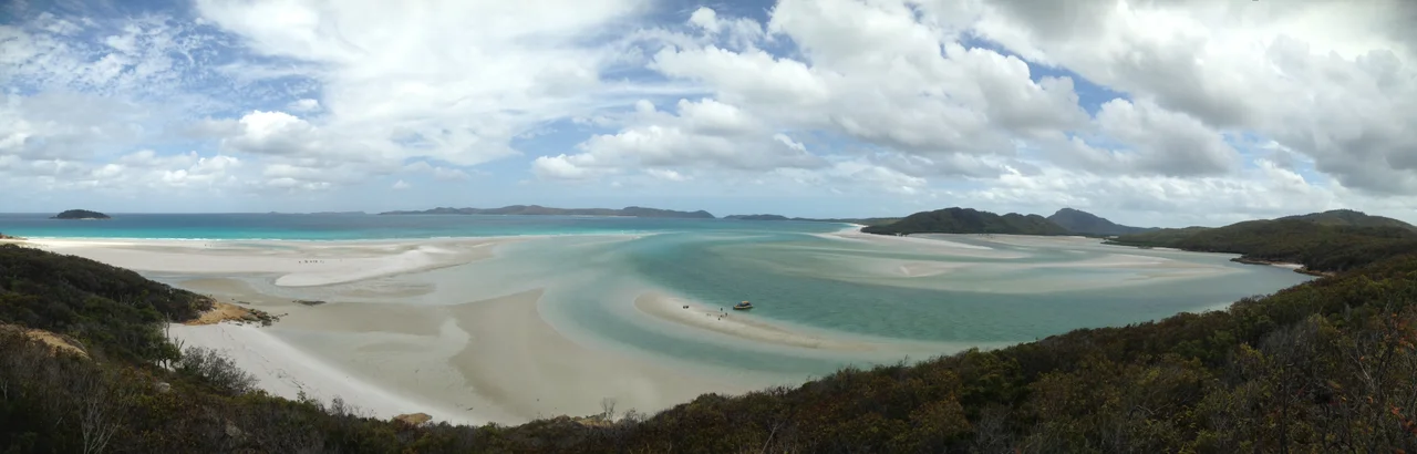
Whitehaven Beach runs for seven kilometres along the eastern edge of Whitsunday Island, and its sand is ninety-eight percent pure silica. The grains are so fine and so reflective that the beach can feel cooler than the air, and sunglasses are not a suggestion but a defence. At the northern end, the tide pulls through Hill Inlet and stirs sand and water into shifting swirls of white and blue that change with every cycle. The purity is no accident of beauty alone. In the 1960s the silica was eyed for industrial use before national park protection closed the door. Today over a hundred boats may anchor off the beach by day, but by late afternoon the tour fleet departs, and anyone who has camped overnight wakes to seven empty kilometres and reef sharks cruising the shallows.
A Playground at the Edge of the Reef
Half a million visitors come each year, and the Whitsundays wear their popularity in layers. Hamilton Island carries an airport, a marina, and some of the most valuable real estate in Australia. In August its harbour fills for Race Week, founded in the 1980s, when thirty-foot charter boats share the start line with billion-dollar superyachts and the whole island tilts toward the water. Yet most of the seventy-four islands hold no resorts at all. They are national park, and a four-dollar permit and a tent will put you alone on a beach where no ferry calls. Between the two extremes lies the real draw: warm aquamarine water, fringing coral within snorkelling distance of the sand, and a flooded mountain range that somehow became the easiest paradise in the country to reach.
From the Air
The Whitsunday group lies at roughly 20.30 degrees south, 148.93 degrees east, off the central Queensland coast between the mainland and the Great Barrier Reef. From altitude the seventy-four forested islands read as a scatter of dark green peaks ringed by pale fringing reef, with Whitehaven Beach a brilliant white slash on the eastern side of Whitsunday Island and Hill Inlet's swirled sandbanks unmistakable at its northern tip. Great Barrier Reef Airport on Hamilton Island (ICAO YBHM) sits in the heart of the group; Whitsunday Coast Airport at Proserpine (YBPN) serves the mainland gateway 35 km west. Tropical haze is common in the wet season (December to March); clearest air and best reef color come in the dry winter months. Beware the 5.9 m tidal range when judging anchorages and reef exposure from above.
Nearby Stories
- Bowen 13 km away
- Cape Hillsborough National Park 39 km away
- Collinsville, Queensland 60 km away
- Great Barrier Reef 92 km away
- Pine Islet Light 147 km away
- Brigalow Belt 160 km away
- Coral Sea Islands 188 km away
- Canal Creek Air Crash 317 km away