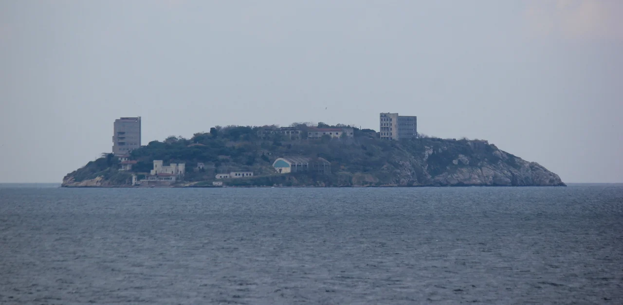

Yassıada
The island's Turkish name means simply "flat island," a plain description of its low, even profile in the Sea of Marmara. But Yassıada has accumulated other names, each reflecting a different chapter of its long history as a place where the powerful sent the inconvenient. The Byzantines knew it as Plati. For much of the 20th century, Turks knew it as the island of the trials — the place where, in 1960 and 1961, a military tribunal judged the members of a democratically elected government and condemned three of them to death. In 2013, the island was officially renamed Demokrasi ve Özgürlükler Adası: Democracy and Freedom Island. Ecologists who watched subsequent construction transform its shoreline gave it a less official third name: Betonada, Concrete Island.
Centuries of Exile
Yassıada's role as a place of confinement is older than Turkey, older than the Ottoman Empire. The Byzantine rulers used Plati as a destination for political exiles from at least the 4th century AD, when the Armenian Patriarch Narses was sent here before being moved to the larger island of Prinkipos. The island was still receiving prisoners in the 11th century — four underground prison cells from that period remain partially visible. Patriarch Ignatios, exiled to the island in 860, built a church there; tunnels under the church were used as a dungeon.
Byzantine Emperor Theophilos constructed the Platea Monastery on the island. In 1204, Latin Crusaders of the Fourth Crusade took the island during their seizure of Constantinople. Centuries later, in 1857, British ambassador Henry Bulwer — brother of novelist Edward Bulwer-Lytton — purchased Yassıada and built a mansion, organizing agricultural production in hopes of partial self-sufficiency. He eventually sold it to Khedive Ismail Pasha of Egypt, who let it fall into neglect. After the Republic of Turkey was established in 1923, the island passed to state ownership. The Turkish Navy bought it in 1947 and built naval schools.
The Coup and the Trials
On May 27, 1960, a military junta calling itself the National Unity Committee seized power in Turkey's first military coup, dissolving Parliament and detaining the leadership of the ruling Democrat Party. Among those arrested were Prime Minister Adnan Menderes and former President Celal Bayar. The trials that followed were held in the naval school buildings on Yassıada, beginning on October 14, 1960, and continuing until September 15, 1961.
The defendants numbered 592 in total. The charges ranged from violating the Constitution to mishandling civil unrest. On September 15, 1961, the court delivered its verdicts, handing down 15 death sentences. Bayar's sentence was later commuted because of his age. Foreign Minister Fatin Rüştü Zorlu and Finance Minister Hasan Polatkan were executed on September 16, 1961 — on the island itself. Adnan Menderes, who had survived a suicide attempt during his imprisonment, was declared medically fit by military doctors and executed on September 17, 1961, at İmralı Island, further south in the Sea of Marmara.
Menderes had been prime minister for ten years. His Democrat Party had won three consecutive elections. Whatever constitutional violations the tribunal found, the executions were widely understood — then and since — as the elimination of political opponents by a military government, not a routine judicial outcome.
Reckoning and Renaming
The aftermath of the Yassıada trials shaped Turkish political culture for decades. The memory of Menderes became a touchstone in Turkish politics, invoked repeatedly as an example of unjust military interference in civilian rule. In 1990, Turkey's Parliament passed a law restoring the honor and reputation of Menderes, Zorlu, and Polatkan. Their reputations had been legally rehabilitated; the men themselves could not be.
In 2013, the island was officially renamed Democracy and Freedom Island — Demokrasi ve Özgürlükler Adası — in memory of the 1960 coup and as a gesture toward erasing the name Yassıada's association with the trials. The renaming was accompanied by a major construction project that alarmed environmental groups. Development transformed sections of the island, earning it the unofficial name Betonada among ecologists critical of the changes. After the naval school era, the island had briefly become a research station for Istanbul University's department of marine biology before strong winds made the work impractical. The island's 45 acres have passed through many hands and many purposes — monastery, dungeon, mansion, naval school, tribunal, and now, officially, a monument to democracy.
What the Island Holds
Yassıada sits southeast of Istanbul in the Sea of Marmara, the southernmost island of the Princes' Islands group. Flat where its sister islands are hilly, it lies close enough to the city to have been useful for centuries and far enough to feel removed. The remains of four underground prison cells from the Byzantine era are still visible. The school buildings where the trials were held still stand.
Visiting the island today means moving through layers of time that do not entirely separate. A monastery built by a Byzantine emperor. Tunnels that served as dungeons. Rooms where men who had won elections were tried for their lives. The name the state gave it speaks of democracy and freedom. The name the ecologists gave it speaks of concrete. The name the Byzantines gave it — Plati, the flat one — describes only what your eyes confirm.
From the Air
Yassıada lies at 40.864°N, 28.993°E in the Sea of Marmara, the southernmost and flattest of the Princes' Islands, approximately 22 kilometers southeast of central Istanbul. Its low, even profile distinguishes it immediately from the steeper neighboring islands visible from the air. The nearest major airport is Sabiha Gökçen (LTFJ), approximately 22 kilometers to the northeast. At 2,000–3,000 feet, the full Princes' Islands chain is visible, with the larger Büyükada immediately to the north. The Istanbul historic peninsula — Hagia Sophia, the Blue Mosque, Topkapı — is visible to the northwest in clear conditions. The Sea of Marmara stretches south toward the Dardanelles.
Nearby Stories
- Second Battle of Çatalca 1.5 km away
- Tarabya 4.1 km away
- Şile 7.9 km away
- Hereke Carpet 12 km away
- Battle of Melantias 19 km away
- Bursa 47 km away
- Bandırma 51 km away
- 2025 Kartalkaya Hotel Fire 192 km away