Zuiderduintjes
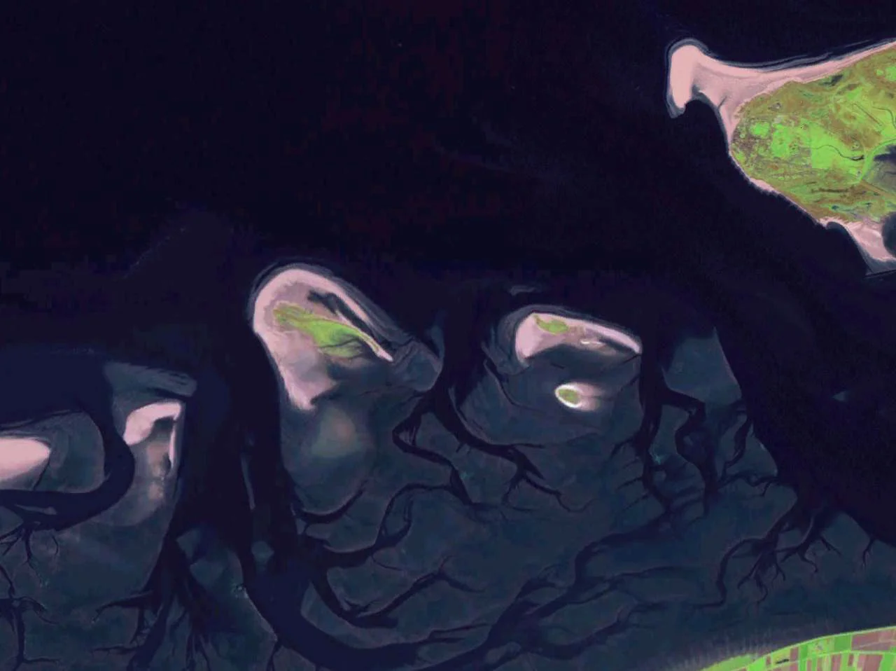
Most countries that own islands like to put people on them. The Netherlands owns Zuiderduintjes, and has decided the opposite. This sliver of sand and salt marsh in the Wadden Sea - roughly 74 hectares, last measured - is one of three islands in the Rottum reserve where access is explicitly forbidden. Not restricted. Not seasonal. Forbidden. Birds and seals get the place to themselves. Humans get a name on a chart and a long lens from a passing boat.
Smaller Than a Small Town
Zuiderduintjes sits south of Rottumeroog, east of Rottumerplaat, and west of the much larger German island of Borkum. In Dutch the name means roughly 'little southern dunes,' which is exactly what it is - a low pile of sand and marsh grass slowly rearranged by every storm tide. In 1995 surveyors put its surface area at 57 hectares. By 2007 it had grown to 74. That is unusual. Most of its neighbors in this stretch of the Wadden Sea are losing ground to erosion, not gaining it. Sand here is on the move constantly, eddying through the tidal channels of the Ems estuary, and Zuiderduintjes happens to sit in a place where the currents drop more than they steal. The island is technically part of the West Frisian chain and falls within the municipality of Het Hogeland in Groningen province, though no Het Hogeland resident has any business there.
A Nature Reserve with No Visitors
Zuiderduintjes belongs to the Rottum nature reserve, which has been progressively closed off to human activity since the 1940s. The reasoning is straightforward: this is a critical resting and foraging area for migratory birds, and a haul-out site for both harbor and grey seals. Both species are skittish around boats and especially around people on foot. Allow tourism, even careful tourism, and the colonies collapse. The Dutch decided some decades ago that they would rather have the colonies. Even researchers visit only rarely, usually by small boat, and almost always to inventory plants or count animals before retreating. A handful of plant species have been catalogued among the dunes and salt marshes: sea couch grass, sea milkwort, glasswort, sea aster, common saltwort. The list reads like a Frisian field guide. None of it is dramatic. All of it matters.
Why You Can Look But Not Land
From the air or from a distance Zuiderduintjes looks unimpressive - a pale crescent of sand fringed with green, sometimes joined to its neighbors at low water, isolated by channels at high tide. The flatness disguises what makes the place valuable. Tidal flats around the island expose vast feeding grounds twice a day: cockles, shrimps, polychaete worms, all the small life that powers the Wadden Sea's astonishing bird traffic. Hundreds of thousands of waders use these mudflats during the spring and autumn migrations, and Zuiderduintjes is one of the rare patches of high ground where they can roost safely between feeding tides. Seals need similar peace. The island's prohibition is not about preserving a view or controlling a fragile soil - it is about giving non-human residents the one thing a coast this busy almost never offers. Quiet.
The Moving Map
Like the rest of the eastern Wadden Sea, Zuiderduintjes is in slow geographical motion. Its growth between 1995 and 2007 was not a fluke; the island has been gradually building up since formal mapping began in the early twentieth century, even as Rottumeroog next door has shrunk. Storm surges still bite, sandbars still shift, and the eventual fate of an island this small in a sea this restless is anyone's guess. For now, Zuiderduintjes endures: low, treeless, off-limits, and full of life. A Dutch island whose best feature is the absence of Dutch people.
From the Air
Coordinates 53.52°N, 6.59°E, in the eastern Dutch Wadden Sea between the island of Rottumeroog (NL) and Borkum (DE). Recommended viewing altitude 1,500-3,000 ft for the clearest sense of the island's shape against the surrounding tidal flats. Low tide reveals the vast mudflat network that gives the area its ecological value; high tide reduces the island to a thin green stripe. Nearest airports: Eemshaven heliport on the Dutch mainland, Borkum (EDWR) just east, Emden (EDWE) southeast. Avoid low passes during seal pupping season (early summer) or major bird migrations (April-May and September-October) - the reserve is protected for a reason.
Nearby Stories
- Hanze University of Applied Sciences 3 km away
- Leybucht 4.6 km away
- Ypey Mole, Ryptsjerk 6.6 km away
- Oldambt 7.8 km away
- Buren, Friesland 15 km away
- HMS Arethusa (1913) 24 km away
- Gemini Wind Farm 28 km away
- SMS Ariadne 41 km away