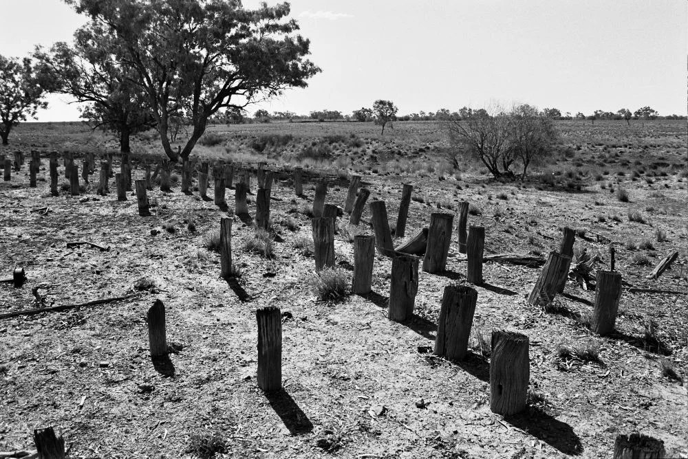
_-_timber_stumps.jpg)
Beaconsfield Station Sheep Wash
On the bank of Brutus Creek, north of Ilfracombe, lie the remains of a machine that tried to outrun history and lost. Around 1893, the owners of Beaconsfield Station built a steam-powered sheep wash here: a dam, a long timber-lined trough, a pump, and twin rail lines to ferry the clean animals to the shed. Within a few years it was abandoned. The ruins survive because the experiment failed quickly, leaving the bones of a brief, ambitious moment when one outback station tried to industrialize a task as old as shepherding itself.
Why Wash a Sheep?
The logic was simple economics. A fleece in the paddock carries dirt, grease, and vegetable matter, burrs and grass seed caught in the wool. All of that adds weight, and weight meant freight cost on the long haul from the outback to the wool sales of London. Washing the sheep before shearing stripped out the worst of it, so what travelled to market was cleaner and lighter and fetched a better price. For generations this had been done by hand in creeks and waterholes. At Beaconsfield, in the dry country west of the Great Dividing Range, the station tried to do it at scale, with steam and machinery, on a creek that did not always cooperate.
The Machine on Brutus Creek
The wash sat about a thousand metres from the shearing shed, built beside a dam on Brutus Creek. A steam pump, set in a timber-lined trough cut into the bank, drew water up to feed the system. The sheep went into the trough and were cleaned by a combination of hand-scrubbing and water jets ranged along its length, then driven up a race on the western side to draining pens. From there they rode to the woolshed on trolleys winched along twin rail lines, the winch most likely powered by the same steam engine that drove the wool press in the shed. It was an ingenious assembly of available technology, improvised far from any engineering works.
Overtaken Almost at Once
The timing was unlucky. Steam-driven scouring works like this one were briefly popular in the early 1890s, but by the decade's end a network of large mechanised wool scours had made them obsolete. Beaconsfield's wash seems to have struggled to find enough water, was judged unsatisfactory, and was abandoned in the 1890s, probably after an artesian bore was sunk at Ilfracombe around 1897 and a proper scour was built nearby. The track and trolleys were stripped out and carried away to sugar mills and to the scours at Cramsie and Ilfracombe. What had been built to last a generation was salvaged for parts within one.
When the Bores Changed Everything
The thing that doomed the wash also transformed the whole district: water from below the ground. In 1893 an artesian bore was sunk at the Beaconsfield shearing shed, and around it twenty-four Wolseley shearing machines were installed, the mechanical handpieces that were already replacing the blades. Reliable bore water made large fixed wool scours practical where creek-fed washes had always been hostage to the seasons. When a bore and a scour came to Ilfracombe itself around 1897, the logic of Beaconsfield's hand-scrubbing trough collapsed. The future of outback wool lay with the deep bores and the big scours, not with men sweating over a creek-side trough hoping the dam held.
A Station and Its Names
Beaconsfield grew into one of Australia's foremost sheep stations under the Fairbairn pastoral empire, among the most extensive holdings in the country. The station passed to Stephen Fairbairn, who later moved to England, but its day-to-day rise owed most to its long-serving resident manager, Walter Anderson, who ran the place through the 1880s and into the early 1900s. The sheep wash listed on the Queensland Heritage Register on 21 October 1992 is the rare physical trace of all this. With its dam, trough, pump, water jet, and tramline still readable on the ground, it is one of the few surviving large-scale sheep washes in outback Queensland, and a quiet record of a wool industry forever chasing the cleanest possible bale.
From the Air
The Beaconsfield Station Sheep Wash ruins lie at 23.33°S, 144.55°E, on the bank of Brutus Creek north of Ilfracombe in outback central western Queensland. The nearest scheduled airfield is Longreach Airport (ICAO: YLRE, IATA: LRE), roughly 30 km to the southwest; Barcaldine Airport (ICAO: YBAR) lies about 55 km to the east. The site sits on flat to gently undulating Mitchell-grass plains cut by ephemeral creek lines, so from the air the most reliable landmark is the timbered course of Brutus Creek threading through open grassland, with the township of Ilfracombe and the Landsborough Highway to the south. The ruins themselves are low and earth-toned and effectively invisible from cruising height; treat the creek and Ilfracombe as your waypoints. Visibility is excellent in the dry season, with afternoon heat haze and occasional summer storm activity.
Nearby Stories
- Aramac Tramway Museum 7.8 km away
- St Peter's Anglican Church, Barcaldine 9.4 km away
- Darr River Downs 22 km away
- Shearers' Strike Camp Site, Barcaldine 30 km away
- Arrilalah 31 km away
- Wellshot Station 44 km away
- Mount Cornish Homestead 53 km away
- Bladensburg National Park 132 km away