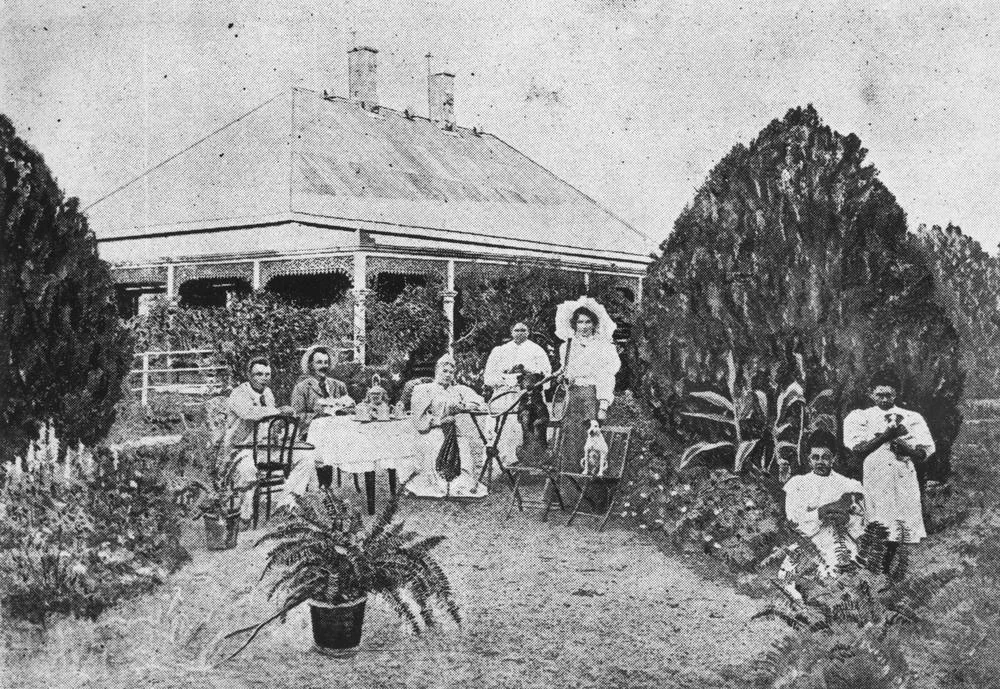

Mount Cornish Homestead
Twelve thousand head of cattle came first. In 1872, the Edkins family drove them out to the head of the Thomson River, into country so far from anywhere that the nearest neighbours measured a day's ride away, and set up house in a mud hut roofed with bark. This was Mount Cornish, an outstation of Bowen Downs, and for a while the difference between civilisation and the open plain was a single thatched room. The stone house came later, once the family had decided the land would hold them. Today it still stands near Muttaburra, a low white building in an ocean of channel-country grass, quietly insisting that someone once chose to stay here.
An Empire Measured in Grass
To understand the homestead, you have to understand Bowen Downs, the colossal run it served. In 1862 the explorers William Landsborough and Nathaniel Buchanan, backed by Scottish investment money, took up a lease so vast it is hard to picture from a verandah. Edward Cornish was among the men who opened it, and his name stuck to this corner of it. Bowen Downs was the kind of holding that swallowed managers whole, and Mount Cornish was the forward post where the work actually happened. Edward Rowland Edkins became its first manager, riding herd over thousands of cattle on land that demanded everything and forgave nothing. The mud hut was not poverty so much as priority. You built fences and watered stock before you built yourself a parlour.
Two Masons and a Quarry
By 1876 the Edkins had a timber house. In 1883 they added something more permanent: a stone section of two rooms wrapped in a verandah, built from white stone quarried roughly a mile away. The work is credited to two highly skilled German masons, part of the surprising web of skilled European tradesmen who found their way to the most remote corners of colonial Queensland, and the quality of their work shows in why the building survives at all. Stone in this country was a statement. Timber and corrugated iron went up fast and came down faster, scattered across the bush wherever a run failed, but cut stone meant a family had stopped improvising and started building for the generations they expected to follow. Out here, where the land could turn a fortune to dust in a single dry season and where the nearest town was a hard day distant, choosing stone was an act of stubborn optimism, a bet that the place was worth permanence.
Drought, Division, and the Long Decline
The optimism was tested. Mount Cornish was partially resumed in 1889 as the government carved up the great pastoral leases for closer settlement. The property was divided again in 1895, and then the rains simply stopped. The drought that followed dragged on until 1902, one of the cruellest in the region's memory, killing stock by the hundreds of thousands across western Queensland and breaking men who had thought themselves unbreakable. The homestead endured. Bowen Downs itself was partially resumed when its lease lapsed in 1927, and the surviving runs carried sheep and cattle into the 1960s. The stone house outlasted the empire that built it.
The River That Kept a Secret
The Thomson River, which begins near here, hides one of Australia's great finds. In 1963, on Rosebery Downs Station downstream near Muttaburra, the grazier Doug Langdon noticed bones weathering out of the ground. They belonged to a seven-metre plant-eating dinosaur from the Cretaceous, and when scientists named it in 1981 they called it Muttaburrasaurus langdoni in his honour. For decades it was the most complete dinosaur skeleton ever found in Australia, and it eventually became the state's official fossil emblem. The same flat, ancient country that tried so hard to break the Edkins family had been keeping that secret for a hundred million years, waiting for a stockman to look down at the right moment.
From the Air
Mount Cornish Homestead sits near Cornish Creek at roughly 22.55 degrees south, 144.61 degrees east, in the open plains country southeast of Muttaburra. Best appreciated from 2,500 to 4,000 feet AGL, where the homestead reads as a small cluster of buildings against the geometry of channel-country grasslands and the thin green thread of the Thomson River system. The nearest strip is the Muttaburra aerodrome (YMTB) a short hop north; Longreach Airport (YLRE) lies to the southwest and Barcaldine Airport (YBAR, field elevation 271 m) to the southeast for fuel and services. This is remote outback flying with sparse navigation references and long distances between fields, so plan reserves generously. Visibility is typically excellent in the dry season; watch for heat haze and dust in summer afternoons.
Nearby Stories
- Aramac Station 14 km away
- Darr River Downs 17 km away
- Edgbaston Reserve 18 km away
- Bexley Station 52 km away
- Bladensburg National Park 111 km away
- Porcupine Gorge 214 km away
- Great Northern Railway (Mt Isa line) 219 km away
- Mining Works on Towers Hill 272 km away