Bourtange moor
Around 5000 BC, the rain stopped draining away from a low valley in what is now northeastern Netherlands and northwestern Germany. The ground stayed wet. Mosses grew. The mosses died, were buried under more mosses, and over five thousand years a bog formed — sphagnum, sedge, and peat layered into a soft black landscape three thousand square kilometers across. It was big enough to swallow armies, and several times it did. It was also wet enough to preserve a body for two thousand years, and several times it did that too. Most of it is gone now. Drained, cut, burned for fuel, planted in buckwheat. But a remnant survives on the international border at the Bargerveen-Bourtanger Moor nature park, and the bog bodies pulled from the peat are still on display in northern European museums.
A V-Shaped Wilderness Between Two Provinces
The Bourtanger Moor had the shape of a V, opening to the south. The western leg followed the valley of the Hunze river up toward the city of Groningen, hemmed in by a low ridge called the Hondsrug. The eastern leg ran south through the valley of the Ems, into what is now German Emsland and the County of Bentheim. Between the two legs lay Westerwolde, a region of slightly higher, drier ground that became one of the few inhabited islands in the swamp. The bog was a barrier and a refuge at the same time — too soft to walk across without dying, too useful to leave alone.
The Wars the Bog Won
Between roughly 1580 and 1850, the swamp had a serious military function. Armies could not cross it, so generals fought over the few hard tracks that did. The wars between the city of Groningen and the Bishop of Münster ran for decades along its edges, and wherever a passage existed, somebody built a stronghold to control it. Bourtange — the star-shaped fortress that gives the bog its name — went up in 1593 on one of those passages. Oudeschans, Nieuweschans, Valtherschans, and Emmerschans followed. The fortifications were squat earth-and-brick affairs designed to take cannon fire and dominate a single road. By the time the bog had been drained enough to march an army through, the strongholds had become tourist attractions, which most of them still are.
Peat, Canals, and the Straight Line
Real industrial peat-cutting began in the sixteenth century, when Frisian engineers introduced a method of digging long parallel canals to drain a bog and float the cut peat out to market. In the seventeenth century, the city of Groningen took control of Westerwolde and commissioned two surveyors, Johan de la Haye and Johan Sems, to draw a straight line through the western leg of the bog. The Semslinie — running from Wolfsbarge near the Zuidlaardermeer south to Ter Apel — is still the border between Drenthe and Groningen province. The Stadskanaal, the City Canal dug in the eighteenth century, largely follows it. Around these waterways grew the veenkoloniën, the peat colonies: long villages of identical houses lined up beside the canals where the cut peat was loaded onto barges and shipped to Dutch cities to be burned in winter stoves.
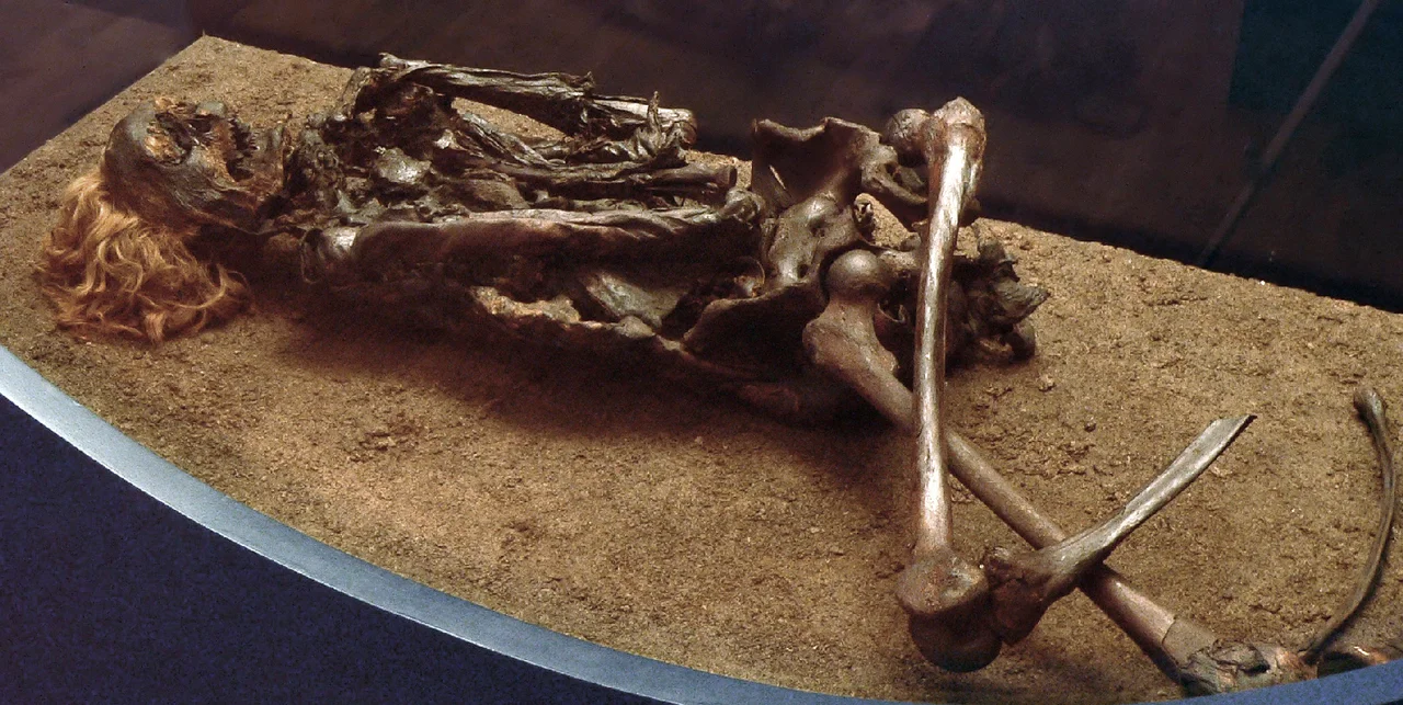
The Bog Bodies
Peat is anoxic, acidic, and cold. Drop a body into it and the body does not rot. Several times, over centuries of digging, workers cut into something that turned out to be a person — Iron Age or early Roman, leathered brown by the bog acids, sometimes with the rope still around the neck. The Weerdinge Men, found near Weerdinge in Drenthe, are two males who appear to have died violent deaths in the first or second century AD. The Aschbroeken Man was also pulled from the Drenthe peat. Roter Franz — Red Franz — came out of the German side, at Neu Versen in Emsland, in 1900, his red beard and hair preserved almost as the day he was killed. The Kibbelgaarn body was found in Groningen province. These were real people who met sudden ends in a place where the ground would keep them visible for two thousand years, and they are still teaching archaeologists how Iron Age northern Europeans lived and died.
What Is Left
By the twentieth century, peat had stopped being a serious fuel — coal and then oil took the market. Cutting continued, but for different products: activated charcoal, peat compost called turfstrooisel, and potting soil. After the Amsterdamse Veld in southeast Drenthe was finally stripped bare, large-scale Dutch harvesting stopped. In Germany, it continued into the twenty-first century. The remnant on the international border is now the Internationaler Naturpark Bourtanger Moor-Bargerveen, with the Bargerveen portion designated as a Ramsar wetland of global importance. It is a thin slice of what was once an immense wilderness, but it is wet again, and the mosses are growing back, slowly, the way they did the first time.
From the Air
Coordinates 52.90 N, 7.26 E (Bourtange fortification), straddling the Dutch-German border between Groningen and Drenthe provinces on the west and Emsland and County of Bentheim on the east. View from 3,000 to 6,000 feet — the surviving moor appears as a darker, wetter patch among the surrounding drained farmland; the long-parallel canals of the old veenkoloniën are visible as straight glints crossing the flat landscape. The star-shaped Bourtange fortress is a striking pentagonal pattern visible from altitude. Nearest airports: Groningen Eelde (EHGG) to the northwest, Münster/Osnabrück (EDDG) to the south. Terrain is uniformly flat, near sea level (1–10 meters), with maritime climate and frequent low cloud.
Nearby Stories
- Museum de Oude Wolden 4.3 km away
- 1977 Dutch Train Hijacking 4.8 km away
- Westerbork 5.6 km away
- Wietmarschen 5.8 km away
- Vriezenveen 17 km away
- Cloppenburg (district) 18 km away
- Alfsee 18 km away
- Bad Zwischenahn 21 km away