Cloppenburg (district)
Cloppenburg has been called the Schweinegürtel — the pig belt — and the description is meant literally. Together with neighboring Vechta, this corner of Lower Saxony has more pigs and turkeys per square kilometer than almost any other German district, the result of poor sandy soil, cheap imported feed, and a century of agricultural industrialization. But the pig belt is only one of Cloppenburg's distinguishing features. It is also one of the very few historically Catholic districts in a state that is overwhelmingly Protestant, a quirk of the old Holy Roman boundaries that has shaped its politics, its families, and its demographics in ways nobody else in Lower Saxony quite shares. Cloppenburg has the highest birth rates and the lowest median ages in Germany. It is, statistically, the country's most fertile corner.
An Accidental Catholic Island
Walk the boundary of the Cloppenburg district and you are walking a centuries-old religious border that nobody drew on purpose. From around 1400 until 1803, this country belonged to the Prince-Bishopric of Münster, the sprawling ecclesiastical state ruled from the cathedral city to the south. In medieval times the area had been part of the County of Tecklenburg before that. The bishop's rule made it Catholic, decisively. When Münster was secularized in 1803 and the territory was handed to Oldenburg — a Protestant Lutheran duchy — the religious character did not budge. The district remained with Oldenburg until 1945, then passed to Lower Saxony, but the Catholic majority survived every administrative reshuffle. The result is the historical region known as the Oldenburger Münsterland, which translates roughly as the lands of Oldenburg formerly held by Münster. Religion outlasted sovereignty by two centuries.
The Safest Seat in Germany
The political consequence shows up every federal election. The Cloppenburg-Vechta constituency is the Christian Democratic Union's safest seat in the country, a CDU bastion that has gone Christian Democrat in all but two elections since the Second World War. In a state where most of the surrounding territory swings reliably between parties, this is a remarkable consistency, and it tracks the religious geography precisely. Catholic-majority districts in northern Germany have a long memory of voting as a bloc, partly out of historical Kulturkampf solidarity and partly because the region's social institutions — schools, hospitals, charities, sports clubs — remain interwoven with the Catholic Church to a degree most of Protestant Germany abandoned generations ago.
Why So Many Children
Cloppenburg's demographic profile is the other surprise. In a country where the birth rate has been below replacement for fifty years and the population is graying rapidly, this district and its Vechta neighbor consistently produce the highest birth rates and the lowest median ages in Germany. The Catholic majority is part of the explanation — practicing Catholic families do, on average, have more children — but the social fabric matters at least as much. The towns are still small enough that extended family networks function, church congregations provide informal childcare, and the cost of housing remains far lower than in metropolitan Germany. Spiegel once called it the Cloppenburg factor, a Kinderparadies inside a country with an aging problem. The young faces in the schoolyards here are real, and they are unusual.
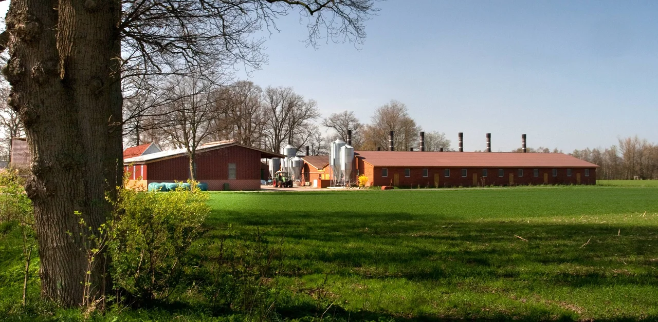
Flat Country, Hard Choices
The geography is plain: an originally swampy plain crisscrossed by small rivers and brooks, with sandy soil that has historically been mediocre for crops. The same poor ground that made the area unattractive for traditional farming is what eventually made factory livestock the dominant business — feed could be imported cheaply, manure could be spread back onto the land, and corn for biogas could be grown with the liquid manure as fertilizer. The cycle is efficient and contentious. Animal-welfare groups, environmentalists, and groundwater regulators have all raised concerns about the density of the operations. The Thülsfelde Reservoir, an artificial lake built between 1924 and 1927 to control flooding, has become a major tourist draw with camping and a youth hostel — a reminder that the same flat country that hosts the pig belt also hosts forest and water that draw weekend visitors from across the region. The district's coat of arms records the layered history honestly: the Oldenburg cross and red stripes, three water-lily leaves from Tecklenburg, the red and yellow of Münster, all quartered together on a single shield.
From the Air
The Cloppenburg district is centered roughly at 52.83 N, 8.00 E in southwestern Lower Saxony, bordering Ammerland, Oldenburg, Vechta, Osnabrück, Emsland, and Leer districts. From altitude the country is flat agricultural land with extensive forest patches and a clear pattern of large livestock facilities visible as long rectangular sheds. The Thülsfelde Reservoir is the most prominent water feature, a long artificial lake in the western part of the district. Nearest airports: Bremen (EDDW) about 60 km east, Münster Osnabrück (EDDG) about 80 km south, Groningen Eelde (EHGG) about 100 km northwest. Light aircraft can use Oldenburg-Hatten (EDWH). Best aerial visibility is high-pressure summer days; the broad plain is unobstructed but can haze quickly in humid conditions.
Nearby Stories
- Meyer Werft 1.8 km away
- Siege of Lingen (1597) 5.9 km away
- Alfsee 9 km away
- Haren, Germany 10 km away
- Bad Zwischenahn 13 km away
- Gardelegen Massacre 202 km away
- Ludwigslust Palace 205 km away
- Wöbbelin Concentration Camp 213 km away