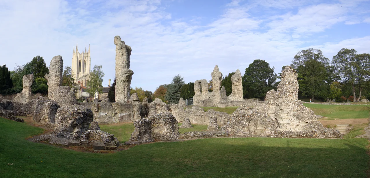

Bury St Edmunds Abbey
In 1327, armed monks threw off their habits to reveal armour underneath, took hostages from the local parish church, and started a battle that left several people dead. This was not an isolated episode. The townspeople of Bury St Edmunds had spent much of that year attacking and burning the abbey gates, seizing charters, tearing debtors' accounts to shreds. The monks had charged tariffs on every economic activity in the town — including the collection of horse droppings from the streets. The abbey had owned all of West Suffolk. And the townspeople had finally had enough.
The Body of a King
The abbey existed because of a death in 869, when the Anglo-Saxon king Edmund was killed by the Great Heathen Army of Danes — executed, in the Christian telling, because he refused to share his kingdom with the pagan invaders or renounce his faith. His body was brought to what would become Bury St Edmunds, and the cult of Saint Edmund drew pilgrims from across England. Around 1020, King Cnut and the Bishop of Elmham established a Benedictine monastery to house the shrine properly. Abbot Baldwin rebuilt the church and reinterred Edmund's body in 1095 with great ceremony. By the 12th century, the abbey church had grown to some 505 feet long and 246 feet across its westerly transept — one of the largest in the country. The shrine of St Edmund stood behind the high altar.
Power, Riot, and the Magna Carta Connection
Few English monasteries wielded temporal power so comprehensively. The abbey ran the Royal Mint. It held wardships over all local orphans, controlling their assets until maturity. It built the town in a grid and taxed it at every transaction. When Abbot Adam Samson discovered in the late 12th century that a local dean had built a windmill without permission, he declared: "By the face of God! I will never eat bread until that building is destroyed!" — and the windmill was demolished. The abbey's connection to the Magna Carta is indirect but real: a meeting of English barons at the abbey in 1214 produced the oath to force King John to accept charter limitations. The Great Riot of 1327 was the reckoning for centuries of this dominance. Queen Isabella arrived with an army from Hainaut on 29 September of that year — not to restore order for the monks' benefit, but to use the abbey as her base for deposing her husband Edward II.
What the Dissolution Left
The abbey settled into a quieter existence after its worst crises. In 1431 the west tower collapsed. Henry VI stayed at the abbey for Christmas 1433 and was still enjoying monastic hospitality four months later. An accidental fire destroyed the entire church in 1465; it was largely rebuilt by 1506. Dissolution came in 1539. Henry VIII's commissioners stripped everything of value, and the ruins were left as a quarry for local builders — arches, dressed stone, and rubble recycled into Bury St Edmunds houses for generations. A collection of wolf skulls was uncovered at the site in 1848. What survived are two extraordinary gatehouses: the Norman Tower, dating from 1120 to 1148, still serving as the belfry for the cathedral beside it; and the 14th-century Abbey Gate, with its portcullis intact. The ruins, owned by English Heritage, now surround a public garden.
The Cloister Cross, Far from Home
Among the treasures the abbey produced was a 12th-century Romanesque altar cross carved from walrus ivory, now known as the Cloisters Cross or the Bury St Edmunds Cross. It is now in the Metropolitan Museum of Art in New York. The art historian Thomas Hoving believed it was carved by the abbey's Master Hugo, though no certain attribution exists, and scholars have proposed Germany as an alternative origin. The cross's journey from a Suffolk abbey to Manhattan is part of the longer story of what happened to the material culture of England's dissolved monasteries — dispersed, traded, eventually collected by institutions far from where they began.
From the Air
Located at 52.24°N, 0.72°E in Bury St Edmunds, Suffolk. The abbey ruins and cathedral are the defining landmarks of the town centre, easily identified from the air. Nearest airports: Norwich Airport (EGSH), approximately 38 miles northeast. Recommended viewing altitude 1,500–2,500 feet. The town's medieval grid plan, laid out by the monks, is still visible in the street pattern below.
Nearby Stories
- Wicken Fen 4.5 km away
- Walden Abbey 7.6 km away
- Saxmundham 10 km away
- East Bergholt 11 km away
- RAF North Pickenham 13 km away
- Acle 13 km away
- Maunsell Forts 16 km away
- Wisbech & Fenland Museum 17 km away