Carihuairazo
In Quichua, the name breaks into three pieces: Cari meaning man, huay meaning wind, razu meaning ice or snow. Man of ice and wind. The Andean storytellers who named this mountain and its neighbor, El Altar, knew what had happened to them both: each was once a great peak, and each was destroyed. The local story explains it directly. Taita Chimborazo - Father Chimborazo - fought them both for the grace of Mama Tungurahua, and he won. What is left of Carihuairazo today is the eroded caldera the fight left behind, a 1.5-kilometer-wide scar opening to the east, a few ragged summits still clawing toward 5,018 meters. The name survives. The mountain it describes does not, quite.
A Ruined Peak
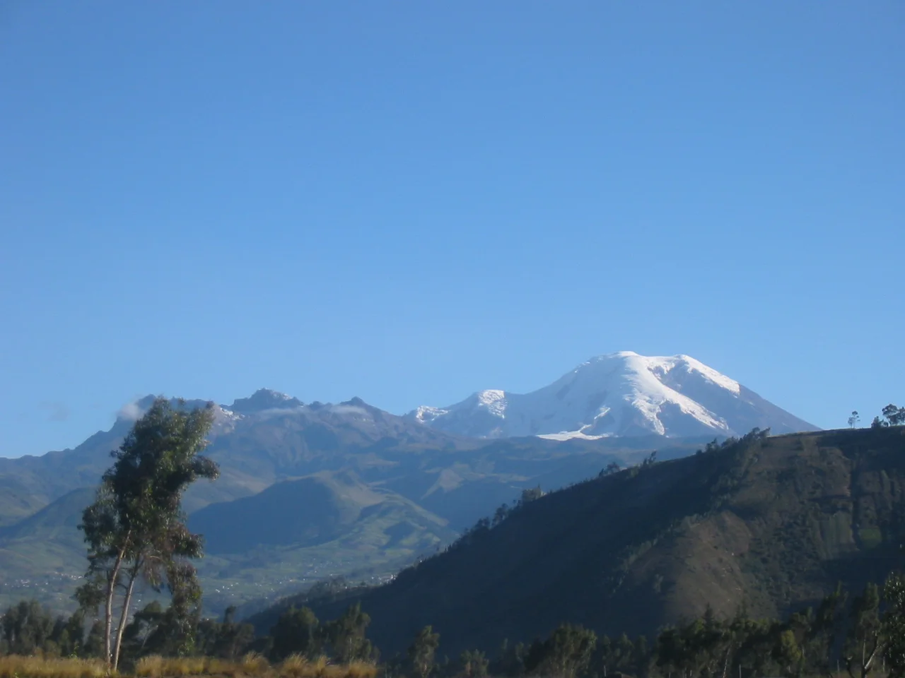
Carihuairazo sits in the Cordillera Occidental of central Ecuador, 150 kilometers south-southwest of Quito. Its nearest human neighbors are the cities of Riobamba, Ambato, and Guaranda - each about thirty kilometers from the mountain, each in a different direction. Its nearest mountain neighbor is Chimborazo itself, massive and ice-capped and still the highest point in Ecuador at 6,263 meters. Geologists can read what the storytellers intuited: Carihuairazo was once a stratovolcano on Chimborazo's scale, and at some point during its last period of activity it tore itself apart. The explosion destroyed the peak and left today's horseshoe-shaped caldera gaping to the east. There is no recorded historical activity here, and the volcano is now considered inactive. What remains are three summits - Mocha at 4,960 meters, the central summit just west of Mocha, and the highest peak, Maxima, at 5,018 meters.
The Glacier That Is Almost Gone
Carihuairazo's glacier has nearly disappeared. The cause is twofold - global warming, which is doing the same to tropical glaciers across the Andes, and ash covers from the eastern neighbor Tungurahua, whose recent eruptions have repeatedly coated Carihuairazo's ice in dark volcanic material. Darker ice absorbs more heat. Darker ice melts faster. In combination, the effects have accelerated a retreat that climbing guides have watched with their own eyes over a single generation. Projections at current rates put complete disappearance sometime between 2020 and 2030 - a window that is already partly in the past. What was once a PD-grade glacier route up the mountain has now become an AD-grade climb, with a technical rock-and-ice push to the summit tower where a glacier used to carry climbers nearly to the top. The mountain has gotten harder because the ice has gone.
Whymper's Cloudy Ascent
Carihuairazo was climbed in 1880 by Edward Whymper - the English mountaineer famous for the first ascent of the Matterhorn - together with his Italian guides, the cousins Louis and Jean-Antoine Carrel, and two Ecuadorians, David Beltran and Francisco Campana. Whymper's team reached the summit in cloud so thick they could not see which peak they had climbed. When the clouds cleared on the descent, Whymper believed they could see that they had reached the west peak, not the Mocha summit to the east. From his description, it is likely he actually meant the central summit just west of Mocha. The first unambiguous ascent of Maxima, the true highest point, came in 1951 - 71 years later - when Arturo Eichler, Horacio Lopez Uribe, and Jean Morawiecki stood on top. Whymper's mistake was the kind of error that could only happen in an age before GPS, when a climber might spend an entire expedition not knowing which summit he had actually reached.
The Vicuna Reserve
Carihuairazo lies within the Reserva de Produccion Faunistica Chimborazo, a protected area designed around its larger neighbor but extending to cover Carihuairazo as well. The reserve exists to preserve the paramo ecosystem - the high-altitude grasslands above 3,500 meters - and particularly to protect the native Andean camelids: vicuna, llama, and alpaca. The vicuna is the wild ancestor whose fleece, finer than cashmere, has been prized since Inca times when only royalty could wear it. Overhunting nearly extinguished them in the twentieth century. Reintroduction programs within the reserve have brought them back to the slopes of Chimborazo and Carihuairazo, where they graze in small herds on tussocky paramo grass, eyes permanently alert for condors and the occasional puma. The modern climber approaches the mountain through land that is recovering, not losing, a piece of its ecological memory.
Climbing What Is Left
Carihuairazo can be climbed year-round, but the best seasons run December through January and July through August. Good acclimatization is essential - the normal route starts from a camping spot at around 4,600 meters and reaches Maxima via the southwest ridge or from the west via the shrinking glacier, finishing with a difficult technical climb onto the summit tower. The mountain sits on the IGM 1:50000 Chimborazo sheet CT-NIV-C1, printed in 1991, which shows a glacier that is mostly no longer there. This is the paradox of climbing Carihuairazo now: it is a mountain in the Quichua legend said to have been destroyed by its bigger neighbor, and it is a mountain whose climbing route has been reshaped by the slow destruction of its ice. Something about the story keeps coming true.
From the Air
Peak at 1.41S, 78.75W, summit elevation 5,018m (16,463ft). Located 150km south-southwest of Quito in Ecuador's Cordillera Occidental, immediately north of Chimborazo. Maintain significant altitude above terrain; tropical mountain weather brings rapid cloud buildup, especially in afternoons. Nearest cities with airports are Ambato (30km NE), Riobamba (30km SE), and Guaranda (30km SW). Best approaches are from Quito or Guayaquil in early morning when the paramo and the horseshoe caldera opening east are clearly visible.
Nearby Stories
- Ventanas 5.3 km away
- Babahoyo 9.6 km away
- Sangay National Park 11 km away
- Pailón del Diablo 15 km away
- Llanganates National Park 21 km away
- Andean Highlands (Ecuador) 27 km away
- Buena Fe Canton 37 km away
- Alausí Canton 50 km away